Difference between revisions of "2011-09-20 45 -121"
From Geohashing
imported>FippeBot m (Location) |
Michael5000 (talk | contribs) (→Photos) |
||
| Line 29: | Line 29: | ||
<gallery perrow="5"> | <gallery perrow="5"> | ||
File:2011-09-20 45 -121 1.JPG|North Central Oregon ranchland, as seen from the hashpoint. | File:2011-09-20 45 -121 1.JPG|North Central Oregon ranchland, as seen from the hashpoint. | ||
| − | File:2011-09-20 45 -121 | + | File:2011-09-20 45 -121 2.JPG|North Central Oregon ranchland, as seen with a GPS in the way. |
File:2011-09-20 45 -121 3.JPG|A glance back at the hashpoint as I drive off in relative triumph. | File:2011-09-20 45 -121 3.JPG|A glance back at the hashpoint as I drive off in relative triumph. | ||
</gallery> | </gallery> | ||
Latest revision as of 20:20, 16 April 2022
| Tue 20 Sep 2011 in 45,-121: 45.1135261, -121.0385805 geohashing.info google osm bing/os kml crox |
.JPG)
Location
In rangeland off of U.S Highway 197 south of Maupin.
Participants
Expedition
This hashpoint was in pastureland just off of Highway 197. I parked, went in a few hundred meters, took some pictures, and left. A fence may or may not have been vaulted.
Expedition Success.
Photos
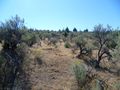
North Central Oregon ranchland, as seen from the hashpoint.
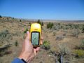
North Central Oregon ranchland, as seen with a GPS in the way.
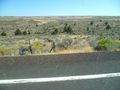
A glance back at the hashpoint as I drive off in relative triumph.


Achievements
Michael5000 earned the Endurance Geohashing Achievement
|