Difference between revisions of "2022-05-22 45 -122"
From Geohashing
Michael5000 (talk | contribs) (Created page with "{{subst:Expedition}}") |
Michael5000 (talk | contribs) |
||
| Line 1: | Line 1: | ||
| − | + | {{meetup graticule | |
| − | |||
| − | |||
| − | |||
| − | |||
| − | |||
| − | |||
| − | |||
| − | |||
| lat={{#explode:{{SUBPAGENAME}}| |1}} | | lat={{#explode:{{SUBPAGENAME}}| |1}} | ||
| lon={{#explode:{{SUBPAGENAME}}| |2}} | | lon={{#explode:{{SUBPAGENAME}}| |2}} | ||
| Line 14: | Line 6: | ||
__NOTOC__ | __NOTOC__ | ||
== Location == | == Location == | ||
| − | + | ||
| + | The sidewalk of Stark Street, on Mt. Tabor. | ||
== Participants == | == Participants == | ||
| − | |||
| − | |||
| − | + | *[[User:Mrs.5000|Mrs.5000]] | |
| − | |||
== Expedition == | == Expedition == | ||
| − | |||
| − | + | Just before [[User:Michael5000|Michael5000]] headed out to his [[2022-05-20 42 -85|Paw Paw patch]] on Friday, he mentioned there was a somewhat closer point on Sunday. So I took a pleasant 40-minute walk from our house (no air travel required) and picked up a sidewalk hashpoint on the north slope of my favorite local volcano. Then I visited the volcano! | |
| − | |||
== Photos == | == Photos == | ||
| − | + | ||
| − | |||
| − | |||
<gallery perrow="5"> | <gallery perrow="5"> | ||
| + | File:2022-05-22 45 -122 a.jpg|View from the hashpoint | ||
| + | File:2022-05-22 45 -122 b.jpg|Triumphant geohasher | ||
| + | File:2022-05-22 45 -122 c.jpg|Up the slopes of the volcano | ||
| + | File:2022-05-22 45 -122 d.jpg|View of downtown, from atop the volcano | ||
</gallery> | </gallery> | ||
== Achievements == | == Achievements == | ||
{{#vardefine:ribbonwidth|800px}} | {{#vardefine:ribbonwidth|800px}} | ||
| − | |||
| − | |||
| − | |||
| − | |||
| − | |||
| − | |||
| − | |||
| − | |||
| − | |||
| − | |||
| − | |||
| − | |||
| − | |||
| − | |||
| − | |||
| − | |||
[[Category:Expeditions]] | [[Category:Expeditions]] | ||
| − | |||
[[Category:Expeditions with photos]] | [[Category:Expeditions with photos]] | ||
| − | |||
| − | |||
| − | |||
| − | |||
| − | |||
[[Category:Coordinates reached]] | [[Category:Coordinates reached]] | ||
| − | |||
| − | |||
| − | |||
| − | |||
| − | |||
| − | |||
| − | |||
| − | |||
| − | |||
| − | |||
| − | |||
| − | |||
| − | |||
| − | |||
| − | |||
| − | |||
| − | |||
| − | |||
Revision as of 02:31, 25 May 2022
| Sun 22 May 2022 in 45,-122: 45.5192826, -122.5915796 geohashing.info google osm bing/os kml crox |
Location
The sidewalk of Stark Street, on Mt. Tabor.
Participants
Expedition
Just before Michael5000 headed out to his Paw Paw patch on Friday, he mentioned there was a somewhat closer point on Sunday. So I took a pleasant 40-minute walk from our house (no air travel required) and picked up a sidewalk hashpoint on the north slope of my favorite local volcano. Then I visited the volcano!
Photos
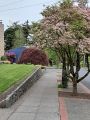
View from the hashpoint

Triumphant geohasher
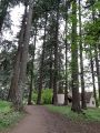
Up the slopes of the volcano
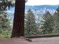
View of downtown, from atop the volcano


