Difference between revisions of "2024-08-04 41 -78"
Pedalpusher (talk | contribs) (New report) |
m (Location) |
||
| Line 71: | Line 71: | ||
[[Category:Coordinates reached]] | [[Category:Coordinates reached]] | ||
[[Category:Expeditions with photos]] | [[Category:Expeditions with photos]] | ||
| + | {{location|US|PA|MC}} | ||
Latest revision as of 00:42, 6 August 2024
| Sun 4 Aug 2024 in 41,-78: 41.9904624, -78.8555386 geohashing.info google osm bing/os kml crox |
Location
Woods of Allegheny National Forest
Participants
Expedition
There was a LOT going on with this expedition with some crazy stuff I got to see and experience almost right from the get-go. With J away visiting family out of town, I had planned on heading to Allegany State Park to finish up my long awaited last hike to complete all the trails in ASP. Having a GeoHash just 'around the corner' was a bonus, especially since the weather today was way better than the day before.
I left around 11:00, but getting to Route 219, I saw some police cars ahead and as I approached, realized they were on both sides of the road. Not sure what to expect, everyone was going by slowly, and I saw 4 cars pulled over, each with a flat tire (and each car had a cop car behind it). First thought was someone dropped a bucket of nails or something, but thinking about it, I had seen tire debris in the road. What I think actually happened was someone had a catastrophic tire blowout and was near the other cars who couldn't avoid it causing their tires to get damaged. Fortunately, it looked like no one was hurt, but I'm sure it was pretty scary.
Then, as I approached the Quaker entrance to ASP, I ran into another group of police, this time it looked like some kind of checkpoint. Pulling up, I said hello and the officer asked if it was just me (weird), and I said Yes. He then said I'm good to go, they were checking for seatbelt usage and since I was wearing mine, there were no issues. However, it looked like Border Patrol was also there so, yeah...'seatbelts', sure buddy.
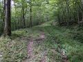
Finally, I got around to the road by the hash and found it without too much trouble and parked next to the gate blocking the Forest Road (vehicles are not allowed on most Allegheny National Forest roads). I turned on my GPS right away, but I figured since I was in the area the last time I used it for this GeoHash, it would pick up a signal right away. It did and I was happy to see I was just about half a mile (about 1 KM) away. It was easy walking on the road and I found the intersection I needed to get pretty close to the hash, and getting to the end of that road, I saw I could continue on a narrower more overgrown trail. It was only when I got 126 feet/38 meters away that I had to go into the woods.
I had a more extensive GPS dance than normal, but was able to eventually get a good reading before heading back to the car. In the parking lot, I found a discarded (and losing) lotto card, so I picked that up to throw away for a GeoTrash ribbon. Also, I had set up a Tale of Two Hashes for Allegany a long time ago thinking I'd eventually have a Hash on this side of the state line to finish it off, so we are finally here.
On the drive back down to the main road, I had a small deer run across the road. Little did I know that this was the beginning of a mini-safari (or so it would seem). Once on the main road and on my way to the other side of ASP, I turned a corner and saw a Black Bear standing on the other side of the road. It saw me coming and decided now was a very bad time to try to cross the road and turned around going back into the woods. I thought it was a small one, but looking them up online, I found that the males average about 300 pounds/136 KG and the females about half that so it was likely an adult.
I then got to the parking spot by the trailhead I wanted outside of Limestone, NY and headed up the trail. This trail has been elusive and I've tried finding it multiple times. The last time I failed to find it, I finally saw a small sign on one of the trail splits on my way back to the car so I now knew what to look for. However, I started hiking up the first split I came to, but something didn't feel right and I couldn't find the signage at this split. I thought I'd hike a little further up the main trail and see if there was another split that looked right and if not, I'd come back here. I'm glad I did, because I was now on course to finish this trail! The first section was pretty nice, well marked, wide and not very overgrown. Then, I turned a corner and saw a velveted 4-point buck staring at me. He didn't move or run off so we just stood there looking at each other from about 30 meters away. I then saw another deer in the woods just off the trail and she wandered out as well and stopped to stare. At this point, I tried 'waving' at them.
My father taught me that they wag their tails side to side as a greeting or to let other deer know that "hey, I'm a deer, too!" He also taught me that you can kind of wave at them in a similar manner and sometimes they respond. So I held my arm parallel to the ground and let my hand fall limp toward the ground (basically so the back of my hand was facing them) and waived it side to side. The female kind of perked up at that and started vigorously wagging her tail, but still neither seemed that spooked. Then, they started walking toward me! A few steps at a time, continuously wagging, they closed the distance by about half. The buck then kind of wandered back into the woods behind the doe and eventually she followed him. Very cool experience, and now that they were off the trail, I continued on my way. When I passed them, they weren't that far into the woods, but I kept waving at them as I walked by, and I'm sure thought that was the weirdest deer friend they ever saw. There was even a third deer than never came out of the woods, but again, none of them spooked.
I should mention that while I lost Simon the dog last year, I brought him along in spirit and attached his collar to my pack. He had done nearly all these trails with me and I wanted to have him in the forefront of my mind as I finished this last trail. He would have loved it, especially the creek that ran by in spots. But then we got to the pipeline and I couldn't tell which way the trail went. I decided to head uphill first but after a while, I still hadn't seen any trail markers. Not sure what to do, I turned around, but it felt like this was the way to go. Sure enough, heading downhill, there was much less of a perceived trail heading in this direction. So again, I back tracked and it turned out I needed to go just a little further before seeing the marker and the turn. Worst case, I figured I could have just hiked the pipeline back to the car and tried again another time. This next section was very overgrown with a lot of stinging nettles and poorly marked trail. I had to be careful, but I made it through and when I got to the trail intersection on the other side, I got really excited because I knew things were about to get much easier and I was almost done!
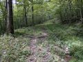
I followed this nice, wide and clear trail the rest of the way back to the main road where I was excited to see where this came out. I definitely needed to find it this way, because from the road, it looked like just two wheel tracks going into the woods with no signage whatsoever. Without knowing what I was looking for, there's no way I would have EVER found this directly. I happily walked the rest of the way back to the car and headed for home where the drive was finally uneventful and I made pizza for dinner.
Photos
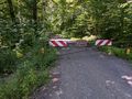
Gate where I parked for the hash.
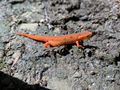
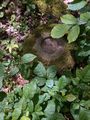
On the walk in, I saw this little guy, a red spotted newt in the Eft stage.
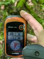
Made it!
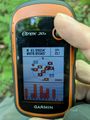
Accuracy.
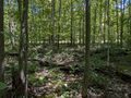
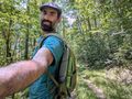
View East and back toward the trail from the hash.
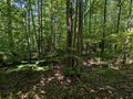
View North.
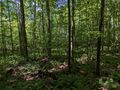
View West.
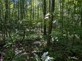
View South.
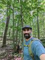
Standard Stupid Grin.
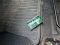
GeoTrash, picked up.
I managed to attach Simon's collar to my pack so he was with me in spirit and I heard the tags jangle as I walked.
The deer coming out of the woods and toward me.
About as close as they got before heading back into the woods.
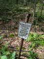
Midway through, I saw this sign in the woods so I went over to check it out.
Turns out it was a survey marker from 1964!


Ribbons
This user earned the Land geohash achievement
|
Pedalpusher earned the GeoTrash Geohash Achievement
|
Pedalpusher earned the Tale of Two Hashes achievement
|