2013-09-23 50 11
| Mon 23 Sep 2013 in 50,11: 50.8981137, 11.5541114 geohashing.info google osm bing/os kml crox |
Location
In the forest near Ammerbach, (almost) on top of the hill (Lämmerberg) as usual and probably on a very steep slope.
Participants
Expedition
Today was Jens' birthday - hooray! The first thing I (Juja) gave him was a nice Birthday Geohash Achievement, and of course writing the report is part of the present...
At first Jens didn't even want to go to the point - he had already been in the area on the weekend before and came to the conclusion that the point would be probably unreachable because of the very steep slope full of thicket and rocks. But I know the Magical Openstreetmap, and there was a tiny path going 20m near the hash, and hooray again, I even explored part of that path already on a former Geohashing expedition, so I knew it really was there. Armed with that knowledge I could finally convince Jens that it would be possible and worth going, and so we set off right after work.
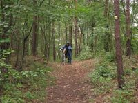
When we reached the last houses of Ammerbach, Jens wanted to leave his bike and go on hiking, but I didn't want to walk that far (because walking is exhausting and biking isn't), so we went on up the hill. Jens followed me like a true hero, but finally we both pushed our bikes - I somehow didn't remember the path being that steep. After a short while we reached the lookout over Ammerbach, and from there on everything was new to us. Surprisingly, there were a lot more tiny footpaths than even OSM knew, so we just picked a nice one, but shortly after that even I gave up: "I didn't think I would ever say this, but what do you think about leaving our bikes right here and walking on?"
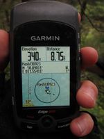
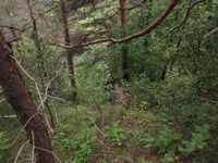
Of course we left the bikes, and that was a good idea, because the narrow path went left and right and up and down so that it was hard to keep up with all the turns even while walking, but after some turns we were 20 meters near the point and would have to climb down the crag and through the thicket now. Well, hard but possible, and the point itself looked almost nice and we even got very near (according to GPS signal).
After taking the usual photos we went back, Jens pushed his bike downhill and probably cursed me and my stupid Geohashing expeditions, while I tried my luck and cycled down. In Ammerbach everything became easy again, so Jens even got some leading kilometers until in Jena our ways parted again and Jens hopefully had a nice birthday evening.
Achievements
Jens earned the Birthday Geohash Achievement
|
Photos
|


