2009-07-10 49 -123
| Fri 10 Jul 2009 in 49,-123: 49.3700966, -123.0038234 geohashing.info google osm bing/os kml crox |
Contents
Location
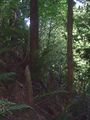
Near hiking trail at Seymour River.
Participants
- Robyn with T-Rex of course
- Rhonda with Sophie!
- Elbie doing the puppet master thing and sending her friend Tom as a proxy
Planning
Find how to get to hiking trail. Hike.
I'm going to bike up there. -- Rhonda 19:00, 10 July 2009 (UTC)
Bus 229 will get you to the lynn canyon suspension bridge area, where you can get on lillooet Rd. to the point.
- Awesome, thanks. Looks like I'll arrive at Lynn Valley Road and Dempsey Road at 2:37 p.m. It's giving me bus 210. -Robyn 19:24, 10 July 2009 (UTC)
- Lynn Valley & Dempsey will get you to Lynn headwaters park (bus 228). Bus 229 turns off lynn valley road at Peters and gets you close to the lynn canyon park visitor's centre, which is where you want to get on Lillooet Rd. -- Rhonda 19:34, 10 July 2009 (UTC)
- Even better. That one gets me to Peters and Duval at 2:26 p.m. -Robyn 19:40, 10 July 2009 (UTC)
Live Expedition Reporting!
Elbie
I checked the coordinates this morning to discover that I didn't have time in my schedule to make it. However, I have a friend, Tom, who lives fairly close to the hashpoint, and I happened to meet up with him this morning. I pretty much just told him he should go, handed him my GPS (pre-programmed for him), and instructed him to take lots of photos.
At 14:45, I figured he'd had enough time to get home and set off, so I gave him a call. He happily reported that he was at Rice Lake, and that he'd be there soon.
At 15:35, he phoned me, and let me know that he'd been bushwhacking for the last half hour trying to get less than 30 metres from the point. I gave him some tips on where to go, and he managed to get within 15 metres of the hash before the GPS got confused and the numbers started changing. We declared him close enough.
At 16:15, Tom phoned to say that he'd ran into Robyn & Rhonda on his way out of the forest.
Tom
Robyn
I refuse to let accessible coordinates in the Vancouver graticule go unsought, so based on the fact that this one was within 300 metres of a road, and within 5 km of transit, it was, by Vancouver standards, welcoming geohashers with open arms.
Rhonda supplied me with the best North Vancouver bus number and I grabbed T-Rex, a ridiculous sun hat and my geohashing bag and went out the door. I turned on the GPS and tossed it in the backpack, as is my habit. I know it will find its satellites and start tracking so it will be ready when I want it. Once on the bus I pulled it out of the bag to confirm that it was, but it was off. I turned it on. It started to boot up and then faded out. Usually it lasts hours after the first low battery warning and I'd had no low battery warnings. But until now I had either been putting freshly recharged batteries in before each trip, or using regular batteries. The rechargeables have such a square power/time profile that they went from fine to dead before the device could issue a warning.
My Vancouver bus to SkyTrain to SeaBus to North Vancouver bus connections were all quite tight. I had an extra minute and thirty seconds coming off the SeaBus before the bus left, and headed towards a convenience store, but as I reached it I saw that the inside was still under construction. Not time to look for another one: I got on the bus and it left. Twenty-five minutes later, one minute before the bus was scheduled to arrive at my stop, it passed a mall. I got off the bus and bought batteries, then asked a passer-by for walking directions to the path through Lynn Canyon to Lillooet Road. He said it was far away. I didn't really believe him, as my now operating GPS said I was only 5.3 km from the geohash, which I knew was on the other side of Lillooet Road, but then he probably had a different definition of "far" that someone who recently walked to Langley. He said, "Just let me move this stuff and I'll give you a ride."
Rhonda and I hadn't arranged an actual meetup time or location, but she knew what bus I was supposed to be on and I was now behind schedule, so I accepted. Besides: hitchhiking achievement! Bill is a retired shipyard supervisor in the industrial cleaning trade, but these days he's doing odd jobs like mowing lawns. I didn't get up the nerve to ask "may I take your picture" before the ride ended, so I had to settle for a quick shot of the departing truck.
He dropped me at the entrance to the Lynn Canyon suspension bridge, but I quickly discovered that the bridge was closed for maintenance. I scrutinized the posted trail map (including the warnings abut cougars and bears in the area) and determined that there was another bridge across the canyon just upriver. It was kind of slow going following the trail because it was full of tourists walking slowly and taking pictures of one another, but I found the Rice Lake Bridge and a park nexus with one of those signposts showing a dozen ways to go. None of them was Lillooet Road, and of the three roads leading away from there, one was marked "closed to the public," and one clearly went south, so I took the one that went north towards the geohash, although it didn't really look like Lillooet Road. It was more of a paved park trail.
There were a number of roads turning off it, with fences and gates and "not open to the public" signs, but the multi-use road kept winding along towards the geohash. I figured I'd meet Rhonda there, or in the vicinity. And then she came up behind me, on her bicycle. "Excellent!" I said, glad of not only her company, but also the formidable weapon her 25 kg bicycle would be against an attacking cougar.
Rhonda
Robyn&Rhonda
Photos
it's down at the bottom of this hill.
