2015-08-14 52 1
From Geohashing
Revision as of 21:25, 14 August 2015 by imported>Sourcerer ([live picture] Proof. [http://www.openstreetmap.org/?lat=52.00773239&lon=1.30593538&zoom=16&layers=B000FTF @52.0077,1.3059])
| Fri 14 Aug 2015 in 52,1: 52.0077248, 1.3059386 geohashing.info google osm bing/os kml crox |
Location
30 metres north of a public footpath, west of Kirton, Suffolk, UK.
Participants
Plans
Expedition one of two spanning midnight - 2015-08-14 52 1 - 2015-08-15 52 1 - ETA 22:40.
Expedition
- Arrived. -- Sourcerer (talk) @52.0077,1.3059 22:24, 14 August 2015 (GMT+01:00)
Photos
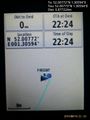
Proof. @52.0077,1.3059

Achievements
Expeditions and Plans
| 2015-08-14 | ||
|---|---|---|
| Mannheim, Germany | elimik31 | Close to the Rhine harbor in Karlsruhe, 10 m from a gravel track in a fores... |
| Frankfurt am Main, Germany | Tads | on a playground in Mainz-Kostheim |
| Halle (Saale), Germany | Reinhard | At the hillside of inglorious Ettersberg north of Weimar, Germany. |
| Norwich, United Kingdom | Sourcerer | 25 metres north of a public footpath, west of Kirton, Suffolk, UK. |
Sourcerer's Expedition Links
2015-08-12 52 1 - 2015-08-14 52 1 - 2015-08-15 52 1 - KML file download of Sourcerer's expeditions for use with Google Earth.