2015-09-26 52 0
From Geohashing
Revision as of 22:22, 26 September 2015 by imported>Sourcerer ([live picture] Proof. [http://www.openstreetmap.org/?lat=52.07381129&lon=.95855713&zoom=16&layers=B000FTF @52.0738,.9586])
| Sat 26 Sep 2015 in 52,0: 52.0737960, 0.9585734 geohashing.info google osm bing/os kml crox |
Location
In a field with public footpaths close by, north of Hadfield, Suffolk, UK.w3w
Participants
Plans
Expedition one of two spanning midnight - 2015-09-26 52 0 - 2015-09-27 52 1 - Eta 22:20.
Expedition
- Arrived. -- Sourcerer (talk) @52.0738,.9586 23:20, 26 September 2015 (GMT+01:00)
Photos
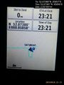
Proof. @52.0738,.9586

Achievements
Sourcerer earned the OpenStreetMap achievement
|
Expeditions and Plans
| 2015-09-26 | ||
|---|---|---|
| St. Louis, Missouri | Kbh3rd | In the Pea Ridge Conservation Area northwest of Potosi. |
| Baltimore, Maryland | Pedalpusher | In Fairland, MD, next to an exit road for a Verizon Office building |
| Lewiston, Idaho | Thomcat | Just east of Rogersburg WA on the banks of the Snake River. |
| Kraków, Poland | Malgond | On a crosswalk in Beliny-Prażmowskiego Street in Kraków. |
| Düsseldorf, Germany | Danatar | in an empty sheep pasture in Langenfeld-Mehlbruch, near Leverkusen. Countr... |
| Cambridge, United Kingdom | Sourcerer | In a field, with public footpaths close by, north of Hadfield, Suffolk, UK.... |
| Amsterdam, Netherlands | JwB | Farmland near Harmelen |
Sourcerer's Expedition Links
2015-09-25 52 1 - 2015-09-26 52 0 - 2015-09-27 52 1 - KML file download of Sourcerer's expeditions for use with Google Earth.