2024-07-12 42 -78
| Fri 12 Jul 2024 in 42,-78: 42.0370316, -78.8101556 geohashing.info google osm bing/os kml crox |
Location
Off the Bear Springs Trail in Allegany State Park
Participants
Expedition
Without any serious plans for the evening, I asked J if she wanted to go to ASP for a Geohash and I figured we could stop somewhere on the way home for dinner. It seemed pretty close to a previous hash I did in the same area two years ago. I looked it up and it seems to be approximately 1,000 feet/300 meters away.
It was a very similar expedition as well with the GPS not picking up a good signal for a while so we had to pause for a minute when we got to the spring at the end of the trail. Once we had a heading, we had to hike through the woods for about a half mile (not quite a KM) to find the hash area. It wasn't a bad GPS dance when we arrived and we got some pictures. The walk back, like last time, also seemed like it went on forever, but I had marked the path on the GPS so at least we had a mark to walk back to and stay more on track.
Once back to the car, we decided to stop in Ellicottville for dinner at the Gin Mill, but as we parked, we saw they where having live music and not wanting to deal with all that (I think that means we are officially old now), we went down the street to a newer Mexican place that turned out to be a good choice.
Photos
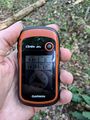
Made it!
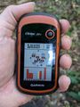
Accuracy
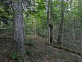
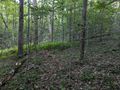
Forest looks all the same, but I'm pretty sure this is the view to the North.
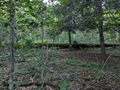
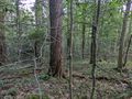
View West.
View South.

View East and where we walked in from.
View of the hash area as we head back.
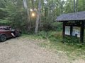
Back at the car at the trailhead with the sun close to going down.


Ribbons
This user earned the Land geohash achievement
|