Difference between revisions of "2008-05-27 54 -2"
From Geohashing
imported>Nicktaylor |
m (fix, sorry) |
||
| (6 intermediate revisions by 4 users not shown) | |||
| Line 7: | Line 7: | ||
==About== | ==About== | ||
| − | On [[2008-05-27|27 May 2008]], the first day of the [[30W Time Zone Rule]], the geohash for [[Carlisle, United Kingdom|Carlisle]] using the [[algorithm]] was | + | On [[2008-05-27|27 May 2008]], the first day of the [[30W Time Zone Rule]], the geohash for [[Carlisle, United Kingdom|Carlisle]] using the [[algorithm]] was along the River Wenning, just outside Wennington, at {{egl|2008-05-27|54|-2|text=54.125367°, -2.577111°}}, within walking distance of a train station. |
| − | Consensus so far seems to have put the meetup location on the near (road-) side of the | + | Consensus so far seems to have put the meetup location on the near (road-) side of the river, not across the river, as the map says. |
| + | |||
| + | There was a stone structure in attendance. Was that built by a geohasher earlier in the day? | ||
== People == | == People == | ||
| Line 17: | Line 19: | ||
== Photos == | == Photos == | ||
| − | + | <gallery widths="200px" heights="160px" perrow="2"> | |
| − | + | Image:2008-05-27_54_-2_stump.jpg|The actual geohash location was likely at the stump. | |
| + | Image:2008-05-27_54_-2_structure.jpg|Someone was here before, making stick-figures. | ||
| + | </gallery> | ||
| + | More photos from [[User:Atl|atl]] at [http://www.flickr.com/photos/atl/sets/72157605283538696/detail/ flickr]. | ||
[[Category:Expeditions]] | [[Category:Expeditions]] | ||
[[Category:Expeditions with photos]] | [[Category:Expeditions with photos]] | ||
| + | [[Category:Coordinates reached]] | ||
| + | {{location|GB|ENG|LAN}} | ||
Latest revision as of 18:45, 18 January 2022
| Tue 27 May 2008 in 54,-2: 54.1253672, -2.5771109 geohashing.info google osm bing/os kml crox |
About
On 27 May 2008, the first day of the 30W Time Zone Rule, the geohash for Carlisle using the algorithm was along the River Wenning, just outside Wennington, at 54.125367°, -2.577111°, within walking distance of a train station.
Consensus so far seems to have put the meetup location on the near (road-) side of the river, not across the river, as the map says.
There was a stone structure in attendance. Was that built by a geohasher earlier in the day?
People
Adam Lindsay, around 4pm.
Photos
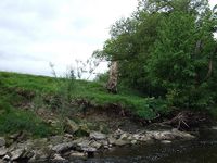
The actual geohash location was likely at the stump.
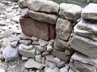
Someone was here before, making stick-figures.

