Difference between revisions of "2009-01-15 67 20"
From Geohashing
imported>The ru |
m |
||
| (10 intermediate revisions by 2 users not shown) | |||
| Line 1: | Line 1: | ||
| − | |||
{{meetup graticule | {{meetup graticule | ||
| map=<map lat="67" lon="20" date="2009-01-15" /> | | map=<map lat="67" lon="20" date="2009-01-15" /> | ||
| Line 6: | Line 5: | ||
| date=2009-01-15 | | date=2009-01-15 | ||
}} | }} | ||
| − | Usually hashpoints in our graticule are deep in the woods, far out of reach. This one was located in the city of Kiruna, near the Porfyren residental area and just below the Luossavaara ski slope. Getting there was easy. [[User:the ru | the ru]] went. It's a popular area to go for a walk in so there were plenty of tracks, but probably none from other geohashers. | + | Usually hashpoints in [[Kiruna, Sweden | our graticule]] are deep in the woods, far out of reach. This one was located in the city of Kiruna, near the Porfyren residental area and just below the Luossavaara ski slope. Getting there was easy. [[User:the ru | the ru]] went. It's a popular area to go for a walk in so there were plenty of tracks, but probably none from other geohashers. |
The temperature was merely -10 C, not nearly cold enough to break the current record. But it was still damn cold when operating the GPS bare-handed. | The temperature was merely -10 C, not nearly cold enough to break the current record. But it was still damn cold when operating the GPS bare-handed. | ||
| + | '''Update''': Hey! I just realized this also qualified for a Cubicle Geohash almost honorable mention! | ||
| − | {{ | + | |
| − | + | {{Easy_geohash | |
| − | + | | latitude = 67 | |
| − | + | | longitude = 20 | |
| − | + | | date = 2009-01-15 | |
| − | + | | name = [[User:the ru|the ru]] | |
| − | }} | + | | image = 2009-01-15_67_20_GPS.jpg |
| + | }} | ||
| + | |||
| + | |||
| + | {{cubicle geohash | latitude = 67 | longitude = 20| date = 2009-01-15| name = [[User:the_ru|the ru]]| honor = almost }} | ||
| Line 26: | Line 30: | ||
| temperature = -10 C | | temperature = -10 C | ||
| name = [[User:the ru|the ru]] | | name = [[User:the ru|the ru]] | ||
| − | | image = 2009- | + | | image = 2009-01-15_67_20_Thermo.jpg |
}} | }} | ||
<gallery perrow="4"> | <gallery perrow="4"> | ||
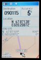
| − | Image:2009-01- | + | Image:2009-01-15_67_20_GPS.jpg | At the hashpoint |
| − | Image:2009-01- | + | Image:2009-01-15_67_20_Slope.jpg | The Luossavaara ski slope |
| − | + | Image:2009-01-15_67_20_Thermo.jpg | -10 C | |
| − | Image:2009-01- | ||
</gallery> | </gallery> | ||
| + | |||
| + | [[Category:Expeditions]] | ||
| + | [[Category:Expeditions with photos]] | ||
| + | [[Category:Coordinates reached]] | ||
| + | {{location|SE|BD}} | ||
Latest revision as of 00:47, 29 November 2023
| Thu 15 Jan 2009 in 67,20: 67.8713923, 20.2087249 geohashing.info google osm bing/os kml crox |
Usually hashpoints in our graticule are deep in the woods, far out of reach. This one was located in the city of Kiruna, near the Porfyren residental area and just below the Luossavaara ski slope. Getting there was easy. the ru went. It's a popular area to go for a walk in so there were plenty of tracks, but probably none from other geohashers.
The temperature was merely -10 C, not nearly cold enough to break the current record. But it was still damn cold when operating the GPS bare-handed.
Update: Hey! I just realized this also qualified for a Cubicle Geohash almost honorable mention!
the ru has visited an Easy Geohash
|
the ru earned the cubicle geohash almost honorable mention
|

the ru earned the Frozen Geohash Achievement
by reaching the (67, 20) geohash on 2009-01-15 while the temperature was -10 C.

At the hashpoint
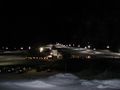
The Luossavaara ski slope
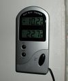
-10 C

