Difference between revisions of "2009-01-31 66 21"
imported>The ru |
m (per Renaming Proposal) |
||
| (9 intermediate revisions by 4 users not shown) | |||
| Line 8: | Line 8: | ||
== [[User:the ru | the ru]] == | == [[User:the ru | the ru]] == | ||
| − | Having learned a few things from my [[2009-01-17 67 21 | previous expedition]], I hoped this wouldn't prove to be as disastrous. I decided to start out early, packed my backpack in the morning watched the sun rise during the hour-and-a-half long drive south. I parked along E10 about 2.6 km from the hash, then proceeded on skis. | + | Having learned a few things from my [[2009-01-17 67 21 | previous expedition]], I hoped this wouldn't prove to be as disastrous. I decided to start out early, packed my backpack in the morning and watched the sun rise during the hour-and-a-half long drive south. I parked along E10 about 2.6 km from the hash, then proceeded on skis. |
The forest was dense, but nowhere near as bad as last time. There were some low hills to climb, but nothing that proved to be a problem. The last 700 m were open, flat terrain - first a lake (which I had discovered earlier on Google Maps), then some frozen bogs. To entertain myself I decided to measure my stride length - turned out I moved about 75 m per 100 steps. I was having '''so much fun''' counting I even overshot the hashpoint by 50 m, so I proceeded with the usual circling around to find the right spot. | The forest was dense, but nowhere near as bad as last time. There were some low hills to climb, but nothing that proved to be a problem. The last 700 m were open, flat terrain - first a lake (which I had discovered earlier on Google Maps), then some frozen bogs. To entertain myself I decided to measure my stride length - turned out I moved about 75 m per 100 steps. I was having '''so much fun''' counting I even overshot the hashpoint by 50 m, so I proceeded with the usual circling around to find the right spot. | ||
| Line 16: | Line 16: | ||
On the way back I saw some dark clouds and... a rainbow!? Never seen that in the winter before. | On the way back I saw some dark clouds and... a rainbow!? Never seen that in the winter before. | ||
| − | I forgot to reset my odometer, so I don't really know how far I went. Probably at least 6 km on skiis and over 250 by car. | + | I forgot to reset my odometer, so I don't really know how far I went. Probably at least 6 km on skiis and over 250 by car. It took over two hours of skiing to get ''to'' the hash, but just an hour to get back. Having prepared tracks really makes it easier. |
| − | I also passed by the Stenbron reststop, where a geocacher was murdered in 2008. :-( | + | I saw two reindeer roadkills. I also passed by the Stenbron reststop, where a geocacher was murdered in 2008. :-( |
On my way back, I made a short detour into Gällivare to refuel both my car and myself. I bought a really sour lemon beverage and some candy. Mmm, calories. | On my way back, I made a short detour into Gällivare to refuel both my car and myself. I bought a really sour lemon beverage and some candy. Mmm, calories. | ||
| + | |||
| + | |||
| + | {{Graticule unlocked | latitude = 66 | longitude = 21 | date = 2009-01-31 | name = [[User:the_ru | the ru]]}} | ||
| + | |||
| + | |||
| + | {{Minesweeper geohash | graticule = Kiruna, Sweden | ranknumber = 1 | se = true | name = [[User:the_ru | the ru]] }} | ||
| + | |||
<gallery perrow="3"> | <gallery perrow="3"> | ||
| − | Image:2009-01-31_66_21_start.jpg | + | Image:2009-01-31_66_21_start.jpg |
| − | |||
| − | |||
| − | |||
Image:2009-01-31_66_21_gnawed.jpg | A hare has gnawed on a tree | Image:2009-01-31_66_21_gnawed.jpg | A hare has gnawed on a tree | ||
| − | |||
| − | |||
Image:2009-01-31_66_21_tracks.jpg | Animal tracks! | Image:2009-01-31_66_21_tracks.jpg | Animal tracks! | ||
| − | |||
Image:2009-01-31_66_21_snowmobile_tracks.jpg | Snowmobile tracks! | Image:2009-01-31_66_21_snowmobile_tracks.jpg | Snowmobile tracks! | ||
| + | Image:2009-01-31_66_21_my_tracks.jpg | My tracks! | ||
| + | Image:2009-01-31_66_21_gps.jpg | @ teh hash | ||
| + | Image:2009-01-31_66_21_rainbow.jpg | The rainbow...? | ||
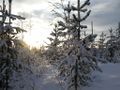
Image:2009-01-31_66_21_sun.jpg | Image:2009-01-31_66_21_sun.jpg | ||
| + | Image:2009-01-31_66_21_fnoske.jpg | A "fnöske" fungus growing on a dead birch | ||
Image:2009-01-31_66_21_stenbron.jpg | Stenbron (the actual bridge is behind the building) | Image:2009-01-31_66_21_stenbron.jpg | Stenbron (the actual bridge is behind the building) | ||
</gallery> | </gallery> | ||
| Line 39: | Line 44: | ||
[[Category:Expeditions]] | [[Category:Expeditions]] | ||
[[Category:Expeditions with photos]] | [[Category:Expeditions with photos]] | ||
| + | [[Category:Coordinates reached]] | ||
| + | {{location|SE|BD}} | ||
Latest revision as of 06:38, 20 March 2024
| Sat 31 Jan 2009 in 66,21: 66.9971020, 21.2379434 geohashing.info google osm bing/os kml crox |
The hash was on a frozen bog, south of Leipojärvi in the Gällivare municipality. the ru went boldly to hash where no one had hashed before and claimed the virgin graticule of 66 21.
the ru
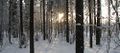
Having learned a few things from my previous expedition, I hoped this wouldn't prove to be as disastrous. I decided to start out early, packed my backpack in the morning and watched the sun rise during the hour-and-a-half long drive south. I parked along E10 about 2.6 km from the hash, then proceeded on skis.
The forest was dense, but nowhere near as bad as last time. There were some low hills to climb, but nothing that proved to be a problem. The last 700 m were open, flat terrain - first a lake (which I had discovered earlier on Google Maps), then some frozen bogs. To entertain myself I decided to measure my stride length - turned out I moved about 75 m per 100 steps. I was having so much fun counting I even overshot the hashpoint by 50 m, so I proceeded with the usual circling around to find the right spot.
I saw lots of animal tracks along the way, mostly from moose and hare. I also heard something that went tock tock, tock, tock, tock tock - probably a woodpecker.
On the way back I saw some dark clouds and... a rainbow!? Never seen that in the winter before.
I forgot to reset my odometer, so I don't really know how far I went. Probably at least 6 km on skiis and over 250 by car. It took over two hours of skiing to get to the hash, but just an hour to get back. Having prepared tracks really makes it easier.
I saw two reindeer roadkills. I also passed by the Stenbron reststop, where a geocacher was murdered in 2008. :-(
On my way back, I made a short detour into Gällivare to refuel both my car and myself. I bought a really sour lemon beverage and some candy. Mmm, calories.
the ru earned the Graticule Unlocked Achievement
|
the ru achieved level 1 of the Minesweeper Geohash achievement
|
A hare has gnawed on a tree
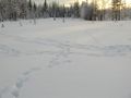
Animal tracks!
Snowmobile tracks!
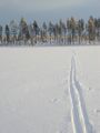
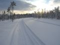
My tracks!
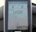
@ teh hash
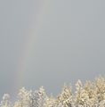
The rainbow...?
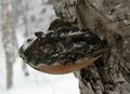
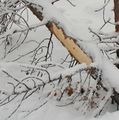
A "fnöske" fungus growing on a dead birch
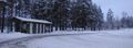
Stenbron (the actual bridge is behind the building)


