Difference between revisions of "2009-02-07 42 -84"
imported>Excellentdude (Initial page setup. Story and pics to come as I reward myself for doing work. :-)) |
imported>FippeBot m (Location) |
||
| (2 intermediate revisions by 2 users not shown) | |||
| Line 8: | Line 8: | ||
== About == | == About == | ||
| + | The coordinates were in the eastbound lane of a rural road between some farms. | ||
== Expedition == | == Expedition == | ||
| + | [[User:Excellentdude|excellentdude]]: While I live in the [[Lansing, Michigan|Lansing]] graticule, this weekend found me traveling to my northeast graticular neighbor, [[Saginaw, Michigan|Saginaw]], to deliver some workshops. As I've already geohashed in the Saginaw graticule, and Michigan isn't a completely crazy regional geohash achievement to go after (though it's close), I was hoping for some good southern coordinates in the [[Tawas, Michigan|Tawas]] graticule to the north. When the coordinates came out Friday, though, that hope was dashed. Not only were the coordinates in the extreme northern end of the graticules, but the Tawas coordinates were in Lake Huron. Another time perhaps. | ||
| + | |||
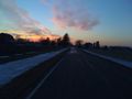
| + | Tawas aside, my journey home that afternoon took me pretty near to the Lansing coordinates so I checked them out. Factoring into that decision was the fact that it was actually warm! Warm, of course, is a relative term. It was about 50°F/10°C and windy. It had rained the last couple days, exposing the mythical ground that was rumored to exist beneath the snow. By the time I got to the interstate exit I needed to take to get to the coordinates, the sun was going down. Remembering some of the [[2009-02-06_33_-85|sunset photos]] that [[User:woodveil|woodveil]] had recently posted, I was hoping to get some of my own. I was a little scared that it would be dark by the time I got to the coordinates, but with my radio reminding about Blue Oyster Cult's advice regarding emotional reactions to farm equipment, I proceeded into the Michigan farmland. Shortly thereafter, I made it to the spot. Truth be told, the sunset pictures probably would have been better if I could have made it ten minutes earlier, but it was a scenic hash nonetheless. Also of note, this was my first non-frozen geohash! | ||
== Achievements == | == Achievements == | ||
| + | {{land geohash | ||
| + | | latitude = 42 | ||
| + | | longitude = -84 | ||
| + | | date = 2009-02-07 | ||
| + | | name = excellentdude | ||
| + | }}{{Speed racer | ||
| + | | latitude = 42 | ||
| + | | longitude = -84 | ||
| + | | date = 2009-02-07 | ||
| + | | name = excellentdude | ||
| + | }}{{consecutive geohash | ||
| + | | count = 2 | ||
| + | | latitude = 42 | ||
| + | | longitude = -84 | ||
| + | | date = 2009-02-07 | ||
| + | | name = excellentdude | ||
| + | }} | ||
== Photos == | == Photos == | ||
| + | <gallery perrow="4"> | ||
| + | Image:2009-02-07 42 -84 GPS Accurate.png|Accuracy | ||
| + | Image:2009-02-07 42 -84 GPS Precise.png|Precision | ||
| + | Image:2009-02-07 42 -84 Hash.jpg|The hash! | ||
| + | Image:2009-02-07 42 -84 Corn Crib SW.jpg|Corn crib to the southwest | ||
| + | Image:2009-02-07 42 -84 CCSW Landscape.jpg | ||
| + | Image:2009-02-07 42 -84 Field South.jpg|Field to the south | ||
| + | Image:2009-02-07 42 -84 Barn East.jpg|Barn to the east | ||
| + | Image:2009-02-07 42 -84 Goofy Grin.jpg|Obligatory goofy grin | ||
| + | Image:2009-02-07 42 -84 Pretty Alpha.jpg|Pretty | ||
| + | Image:2009-02-07 42 -84 Pretty Beta.jpg|Also pretty | ||
| + | Image:2009-02-07 42 -84 Speedometer.jpg|Speedracer | ||
| + | </gallery> | ||
[[Category:Expeditions]] | [[Category:Expeditions]] | ||
| Line 20: | Line 54: | ||
[[Category:Meetup on 2009-02-07]] | [[Category:Meetup on 2009-02-07]] | ||
[[Category:Meetup in 42 -84]] | [[Category:Meetup in 42 -84]] | ||
| + | {{location|US|MI|SH}} | ||
Latest revision as of 02:05, 6 August 2019
| Sat 7 Feb 2009 in Lansing: 42.9706489, -84.2761965 geohashing.info google osm bing/os kml crox |
Contents
About
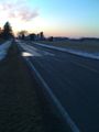
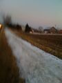
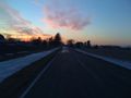
The coordinates were in the eastbound lane of a rural road between some farms.
Expedition
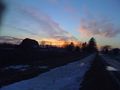
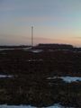
excellentdude: While I live in the Lansing graticule, this weekend found me traveling to my northeast graticular neighbor, Saginaw, to deliver some workshops. As I've already geohashed in the Saginaw graticule, and Michigan isn't a completely crazy regional geohash achievement to go after (though it's close), I was hoping for some good southern coordinates in the Tawas graticule to the north. When the coordinates came out Friday, though, that hope was dashed. Not only were the coordinates in the extreme northern end of the graticules, but the Tawas coordinates were in Lake Huron. Another time perhaps.
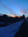
Tawas aside, my journey home that afternoon took me pretty near to the Lansing coordinates so I checked them out. Factoring into that decision was the fact that it was actually warm! Warm, of course, is a relative term. It was about 50°F/10°C and windy. It had rained the last couple days, exposing the mythical ground that was rumored to exist beneath the snow. By the time I got to the interstate exit I needed to take to get to the coordinates, the sun was going down. Remembering some of the sunset photos that woodveil had recently posted, I was hoping to get some of my own. I was a little scared that it would be dark by the time I got to the coordinates, but with my radio reminding about Blue Oyster Cult's advice regarding emotional reactions to farm equipment, I proceeded into the Michigan farmland. Shortly thereafter, I made it to the spot. Truth be told, the sunset pictures probably would have been better if I could have made it ten minutes earlier, but it was a scenic hash nonetheless. Also of note, this was my first non-frozen geohash!
Achievements
excellentdude earned the Land geohash achievement
|

excellentdude earned the Consecutive geohash achievement
|
Photos
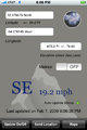
Accuracy
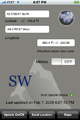
Precision
The hash!
Corn crib to the southwest
Field to the south
Barn to the east

Obligatory goofy grin
Pretty
Also pretty
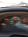
Speedracer


