Difference between revisions of "2009-02-13 67 20"
From Geohashing
imported>FippeBot m (Location) |
m |
||
| Line 29: | Line 29: | ||
Image:2009-02-13_67_20_tracks.jpg | <del>Reindeer</del> Uolta tracks - these creatures sure seem... erratic, don't they? | Image:2009-02-13_67_20_tracks.jpg | <del>Reindeer</del> Uolta tracks - these creatures sure seem... erratic, don't they? | ||
Image:2009-02-13_67_20_gps.jpg | Proof of location and temperature | Image:2009-02-13_67_20_gps.jpg | Proof of location and temperature | ||
| − | |||
</gallery> | </gallery> | ||
Latest revision as of 00:43, 29 November 2023
| Fri 13 Feb 2009 in 67,20: 67.4542140, 20.6897951 geohashing.info google osm bing/os kml crox |
The hashpoint was 20 km west of Skaulo, about 250 m from the Kaitum road.
the ru
The worlds coldest hashpoint reached so far: -22.8 C.
Yet another dark, snowy forest expedition, not that much to say about this one. Drove most of the way, then proceeded on skis. Terrain didn't cause any trouble, only sparse forest. It was my darkest expedition ever though, I barely saw anything at all out there.
the ru earned the Cold geohash achievement
|
the ru earned the Land geohash achievement
|
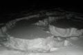
ReindeerUolta tracks - these creatures sure seem... erratic, don't they?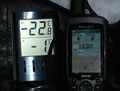
Proof of location and temperature

