Difference between revisions of "2009-03-11 52 0"
imported>Benjw (New page: {{meetup graticule | lat=52 | lon=0 | date=2009-03-11 | graticule_name=Cambridge | graticule_link=Cambridge, United Kingdom }} Today's geohash was in a field in Duxford, just south of Camb...) |
imported>Benjw (expedition write-up) |
||
| Line 6: | Line 6: | ||
| graticule_link=Cambridge, United Kingdom | | graticule_link=Cambridge, United Kingdom | ||
}} | }} | ||
| − | Today's geohash was in a field in Duxford, just south of Cambridge. [[User:Benjw|Benjw]] paid a visit in the afternoon. | + | Today's geohash was in a field in Duxford, just south of Cambridge. [[User:Benjw|Benjw]] paid a visit in the afternoon, after work. The second part of the Double Geohash expedition is [[2009-03-11 52 -0|here]]. |
| + | |||
| + | == Expedition == | ||
| + | === [[User:Benjw|Benjw]] === | ||
| + | |||
| + | This is becoming relatively common -- a geohash in a field, close enough to the prime meridian to allow me to visit another one (also in a field) quite close by. Today's Cambridge graticule geohash was just outside Duxford village, south of Cambridge. | ||
| + | |||
| + | Duxford has a few claims to fame. It has an Imperial War Museum, and an airfield. It even has a Concorde -- which will never take off again now it's there, because they chopped a bit off the runway to build the M11 motorway, and now it's too short for Concorde to take off again. It's also the home of John Rutter, the composer. And it's got the headquarters of Volvo. | ||
| + | |||
| + | It also has a hashpoint, and it was only two villages away from where I had to be all morning. So I went. | ||
| + | |||
| + | Once I'd found somewhere out-of-the-way to leave the car, I enjoyed a nice stroll in the sunshine up a track between a field and a narrow strip of woodland. I seemed to be going up a hill -- a rarity in this area. When I crested the top of the rise, I found a large pond, complete with ducks. It must be man-made as you wouldn't expect to find a pond at the ''top'' of a hill, but how long it's been there, I don't know. I sat for a while and enjoyed the splendid views over the museum/airfield, Thriplow village, and over the fields I could even see as far as the cement works at Barrington, probably about 10km away. | ||
| + | |||
| + | I then realised that I'd gone too far up the hill, in my eagerness to see what was at the top. I went back down, and through the trees to the field on the other side. There were large tractor ruts in the field, which I walked in until I was about 5m from the hashpoint, and then I stepped between the plants for the last bit. | ||
| + | |||
| + | Just for a change, I then walked back along the ''other'' side of the trees. | ||
| + | |||
| + | == Shiny ribbons earned == | ||
| + | {{land geohash | ||
| + | | latitude = 52 | ||
| + | | longitude = 0 | ||
| + | | date = 2009-03-11 | ||
| + | | name = [[User:Benjw|Benjw]] | ||
| + | | image = 2009-03-11 52 0 view.jpg | ||
| + | }} | ||
| + | |||
| + | == Photographic documentation == | ||
| + | |||
| + | <gallery> | ||
| + | Image:2009-03-11 52 0 motorway.jpg|The M11 motorway and Duxford Imperial War Museum. | ||
| + | Image:2009-03-11 52 0 bunny.jpg|A rabbit enjoying the sun. | ||
| + | Image:2009-03-11 52 0 pond.jpg|A pond at the top of the hill. | ||
| + | Image:2009-03-11 52 0 edge of pond.jpg|Ripply patterns at the pond's edge. | ||
| + | Image:2009-03-11 52 0 view.jpg|View from the top of the hill. | ||
| + | Image:2009-03-11 52 0 gps.jpg|Proof of hash. | ||
| + | Image:2009-03-11 52 0 ben.jpg|Ben at the hashpoint. | ||
| + | Image:2009-03-11 52 0 airfield.jpg|Duxford airfield, from the hashpoint. | ||
| + | </gallery> | ||
[[Category:Expeditions]] | [[Category:Expeditions]] | ||
[[Category:Expeditions with photos]] | [[Category:Expeditions with photos]] | ||
[[Category:Coordinates reached]] | [[Category:Coordinates reached]] | ||
Revision as of 22:24, 14 March 2009
| Wed 11 Mar 2009 in Cambridge: 52.0756037, 0.1407393 geohashing.info google osm bing/os kml crox |
Today's geohash was in a field in Duxford, just south of Cambridge. Benjw paid a visit in the afternoon, after work. The second part of the Double Geohash expedition is here.
Expedition
Benjw
This is becoming relatively common -- a geohash in a field, close enough to the prime meridian to allow me to visit another one (also in a field) quite close by. Today's Cambridge graticule geohash was just outside Duxford village, south of Cambridge.
Duxford has a few claims to fame. It has an Imperial War Museum, and an airfield. It even has a Concorde -- which will never take off again now it's there, because they chopped a bit off the runway to build the M11 motorway, and now it's too short for Concorde to take off again. It's also the home of John Rutter, the composer. And it's got the headquarters of Volvo.
It also has a hashpoint, and it was only two villages away from where I had to be all morning. So I went.
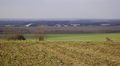
Once I'd found somewhere out-of-the-way to leave the car, I enjoyed a nice stroll in the sunshine up a track between a field and a narrow strip of woodland. I seemed to be going up a hill -- a rarity in this area. When I crested the top of the rise, I found a large pond, complete with ducks. It must be man-made as you wouldn't expect to find a pond at the top of a hill, but how long it's been there, I don't know. I sat for a while and enjoyed the splendid views over the museum/airfield, Thriplow village, and over the fields I could even see as far as the cement works at Barrington, probably about 10km away.
I then realised that I'd gone too far up the hill, in my eagerness to see what was at the top. I went back down, and through the trees to the field on the other side. There were large tractor ruts in the field, which I walked in until I was about 5m from the hashpoint, and then I stepped between the plants for the last bit.
Just for a change, I then walked back along the other side of the trees.
Shiny ribbons earned
Benjw earned the Land geohash achievement
|
Photographic documentation
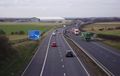
The M11 motorway and Duxford Imperial War Museum.
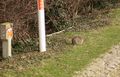
A rabbit enjoying the sun.
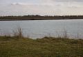
A pond at the top of the hill.
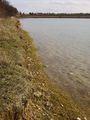
Ripply patterns at the pond's edge.
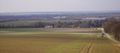
View from the top of the hill.
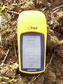
Proof of hash.
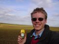
Ben at the hashpoint.
Duxford airfield, from the hashpoint.


