Difference between revisions of "2009-05-03 48 -122"
imported>Rhonda (→Photos) |
imported>Rhonda m (formatting) |
||
| Line 18: | Line 18: | ||
===Raspberry field=== | ===Raspberry field=== | ||
[[Image:2009-05-03 48 -122.rhonda.JPG|thumb|Rhonda and our bikes at the geohash]] | [[Image:2009-05-03 48 -122.rhonda.JPG|thumb|Rhonda and our bikes at the geohash]] | ||
| + | [[Image:2009-05-03 48 -122.gps.JPG|thumb|Proof of location]] | ||
| + | |||
===Lunch=== | ===Lunch=== | ||
===Border=== | ===Border=== | ||
===Transit=== | ===Transit=== | ||
| − | |||
Revision as of 06:39, 4 May 2009
| Sun 3 May 2009 in 48,-122: 48.8703338, -122.5135538 geohashing.info google osm bing/os kml crox |
Contents
Location
Participants
Expedition
Robyn and Rhonda came here after camping overnight at another geohash.
Road
With our bicycles reloaded, we set out south, aiming to pass around the other end of the ridge that we had avoided on the way here. The rain had left no evidence of our chalk marks at yesterday's geohash, but the Internet had moved on, and yesterday's point was no longer of any interest to anyone.
We turned right onto Washington route 542 and followed it for about 27 kilometres, through Maple Falls, Kendall, and Deming (where we ate a snack at a picnic table in front of the public library). A few more rights and lefts and ups and down brought us to Aldrich Road, four hundred metres from the geohash.
Raspberry field


Lunch
Border
Transit
Photos
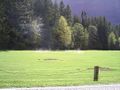
Sunlight after rain
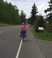
On the road again...
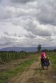
Getting closer
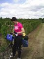
And the GPS says...


