Difference between revisions of "2009-05-03 48 -122"
imported>Rhonda (→Photos: that's all of my pics) |
imported>Robyn m (Moved photo) |
||
| Line 21: | Line 21: | ||
===Raspberry field=== | ===Raspberry field=== | ||
[[Image:2009-05-03 48 -122.rhonda.JPG|thumb|right|Rhonda and our bikes at the geohash]] | [[Image:2009-05-03 48 -122.rhonda.JPG|thumb|right|Rhonda and our bikes at the geohash]] | ||
| − | |||
We cruised along this mostly flat, very straight rural road, riding side by side and taking up the entire lane except for a couple of times when a car was coming. We were looking for Piper Rd., which was right across from the buildings nearest the field, which we thought might be the owners. | We cruised along this mostly flat, very straight rural road, riding side by side and taking up the entire lane except for a couple of times when a car was coming. We were looking for Piper Rd., which was right across from the buildings nearest the field, which we thought might be the owners. | ||
| Line 30: | Line 29: | ||
We pushed our bikes along the road since there were large, mud-filled potholes and the road surface was packed dirt - eminently suitable for a tractor's wide tires, but not quite so good for bicycles. | We pushed our bikes along the road since there were large, mud-filled potholes and the road surface was packed dirt - eminently suitable for a tractor's wide tires, but not quite so good for bicycles. | ||
| − | To the corner of the field, around the corner onto another access road, and we counted down the last few metres. And there it was, right on the edge of the access road, right beside some bundled up raspberry vines. | + | To the corner of the field, around the corner onto another access road, and we counted down the last few metres. And there it was, right on the edge of the access road, right beside some bundled up raspberry vines. |
| − | Both of us admired the cleverness of bundling up the raspberry plants in this way, being more accustomed to picking raspberries from the impenetrable tangles that they normally formed. | + | Both of us admired the cleverness of bundling up the raspberry plants in this way, being more accustomed to picking raspberries from the impenetrable tangles that they normally formed. Robyn had assumed she was in a vineyard right up to the point that Rhonda pointed out that the plants had raspberry leaves. |
Our photos and proof collected, we opted to not leave a marker and went back to the road the same way we came in, then continued riding northward, now heading for Canada. | Our photos and proof collected, we opted to not leave a marker and went back to the road the same way we came in, then continued riding northward, now heading for Canada. | ||
===Lunch=== | ===Lunch=== | ||
| + | We were actually quite close to the Canadian border having passed the | ||
===Border=== | ===Border=== | ||
===Transit=== | ===Transit=== | ||
| Line 47: | Line 47: | ||
Image:2009-05-03 48 -122.getting-closer.jpg|Getting closer | Image:2009-05-03 48 -122.getting-closer.jpg|Getting closer | ||
Image:2009-05-03 48 -122.gps-dance.jpg|And the GPS says... | Image:2009-05-03 48 -122.gps-dance.jpg|And the GPS says... | ||
| + | Image:2009-05-03 48 -122.gps.JPG|... we don't have to go into the field | ||
Image:2009-05-03 48 -122.border-returning.jpg|Back toward Canada | Image:2009-05-03 48 -122.border-returning.jpg|Back toward Canada | ||
Image:2009-05-03 48 -122.bus-shelter.jpg|Waiting for the bus home | Image:2009-05-03 48 -122.bus-shelter.jpg|Waiting for the bus home | ||
Revision as of 15:45, 4 May 2009
| Sun 3 May 2009 in 48,-122: 48.8703338, -122.5135538 geohashing.info google osm bing/os kml crox |
Contents
Location
In an agricultural field, right on the edge of a farm access road according to google maps. It appeared very likely that we could get within GPS accuracy without actually going into the cultivated area.
Participants
Expedition
Robyn and Rhonda came here after camping overnight at another geohash.
Road
With our bicycles reloaded, we set out south, aiming to pass around the other end of the ridge that we had avoided on the way here. The rain had left no evidence of our chalk marks at yesterday's geohash, but the Internet had moved on, and yesterday's point was no longer of any interest to anyone.
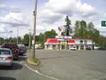
We turned right onto Washington route 542 and followed it for about 27 kilometres, through Maple Falls, Kendall, and Deming (where we ate a snack at a picnic table in front of the public library). A few more rights and lefts and ups and down brought us to Aldrich Road, four hundred metres from the geohash.
Raspberry field

We cruised along this mostly flat, very straight rural road, riding side by side and taking up the entire lane except for a couple of times when a car was coming. We were looking for Piper Rd., which was right across from the buildings nearest the field, which we thought might be the owners.
At Piper Rd. we turned into the driveway of the house, right beside the field's access road. Robyn walked around to the back door to knock, since the front door was behind a fence and some tall weeds. A cat that moved so little Robyn thought it was a statue at first watched us, and some dogs barked at us from somewhere inside. Robyn noticed that the "town truck" didn't seem to be there, and probably nobody was home.
We conferred briefly and decided that since the access road wasn't gated, and we were pretty sure we wouldn't have to leave it based on the google maps image, we would go down the access road and get as close as possible to the hash point.
We pushed our bikes along the road since there were large, mud-filled potholes and the road surface was packed dirt - eminently suitable for a tractor's wide tires, but not quite so good for bicycles.
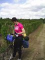
To the corner of the field, around the corner onto another access road, and we counted down the last few metres. And there it was, right on the edge of the access road, right beside some bundled up raspberry vines.
Both of us admired the cleverness of bundling up the raspberry plants in this way, being more accustomed to picking raspberries from the impenetrable tangles that they normally formed. Robyn had assumed she was in a vineyard right up to the point that Rhonda pointed out that the plants had raspberry leaves.
Our photos and proof collected, we opted to not leave a marker and went back to the road the same way we came in, then continued riding northward, now heading for Canada.
Lunch
We were actually quite close to the Canadian border having passed the
Border
Transit
Photos
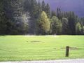
Sunlight after rain
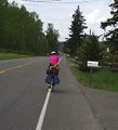
On the road again...
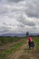
Getting closer
And the GPS says...

... we don't have to go into the field
Back toward Canada
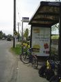
Waiting for the bus home


