Difference between revisions of "2009-06-20 30 -81"
imported>Woodveil (→The Trip) |
m |
||
| (11 intermediate revisions by 4 users not shown) | |||
| Line 1: | Line 1: | ||
{{meetup graticule | {{meetup graticule | ||
| − | |||
| lat=30 | | lat=30 | ||
| lon=-81 | | lon=-81 | ||
| Line 8: | Line 7: | ||
}} | }} | ||
| − | |||
| − | == | + | == Location == |
| + | South of Kingsly in Orange Park | ||
| − | + | == Participants == | |
| + | * [[User:Woodveil|Woodveil]] | ||
| + | * Chris | ||
| + | |||
| + | |||
| + | == Plans == | ||
| + | |||
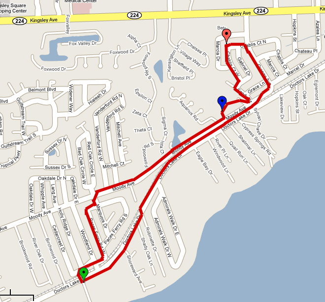
| + | [[image:2009-06-20 route.jpg | thumb | left | We went counterclockwise again. Green = start, red = hash, blue = police.]]We were down at the [http://en.wikipedia.org/wiki/Castillo_de_San_Marcos Castillo de San Marcos] in St. Augustine on Friday afternoon and decided to check the day's hash, in case it was on our way home. It wasn't, but since it was Friday we went ahead and checked the hashes for Saturday and Sunday. As soon as Saturday's coordinates came up on Nick's iPhone, we knew they ''had'' to be close to our Orange Park location. Once the map showed up, our hopes were confirmed. It was ''in'' Orange Park, just south of Kingsley, and on a road! Well, in someone's driveway, but we could still reach it. In fact, it was only a couple streets down from our route on [[2009-06-15 30 -81|Monday's hash]]. We immediately decided to [[walk geohash | walk]] to the hash, a distance we discovered after further investigation to be less than two miles. | ||
| + | |||
| + | ==Expedition== | ||
=== The Trip === | === The Trip === | ||
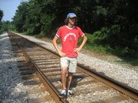
| − | With gps and iPods in tow, we set out on foot around 3:15. We'd decided to throw in a [[Tron achievement]] too, which meant walking an extra few hundred feet. We got to the point a few minutes before 4:00, and it was farther into someone's front yard than previously thought. It was actually on a doorstep. Next door a man was mowing his lawn and trying to figure out what we were doing, so we asked | + | [[Image:2009-06-20 cop 1.jpg | thumb | right | Riding away.]]With gps and iPods in tow, we set out on foot around 3:15. We'd decided to throw in a [[Tron achievement]] too, which meant walking an extra few hundred feet. We got to the point a few minutes before 4:00, and it was farther into someone's front yard than previously thought. It was actually on a doorstep. Next door a man was mowing his lawn and trying to figure out what we were doing, so we approached him and asked if we could take some pictures in his neighbor's yard. He said they weren't home but suggested we'd have to go and ask. So we went up to the house, and made the point in the process. We stood on the doorstep, nervously taking a photo of the gps and thinking up something good to say. Then we decided to just split. Either way, we had already made the point and didn't want to bother anybody. So we continued on our way, coming within about 70 feet of our route at one point, but staying sufficiently far away as to not invalidate the Tron achievement. |
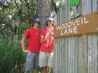
| − | [[Image:2009-06-20 | + | [[Image:2009-06-20 woodveil sign.jpg | thumb | left | That's right, we're named after a street. What of it?]]As it was nearly 100 degrees outside, we decided to try the water fountains at an elementary school on Moody Road when something wonderful happened. A police officer on a motorcycle pulled in. He watched us to make sure we wouldn't break anything, and we passed him later on. Chris casually said "hey." |
"How's it going?" the officer responded. | "How's it going?" the officer responded. | ||
| − | Successful [[Police Geohash]]! He rode a little farther up the road and met up with another officer, and they set up a little speed trap on Moody Road. | + | Successful [[Police Geohash]]! He rode a little farther up the road and met up with another officer, and they set up a little speed trap on Moody Road. Good day to be walking. From there we unceremoniously continued home, stopping only for photos with our namesake street sign. We got home around 4:45, happy with an expedition that just kept getting better. And pitying [[user:Mr. Bow Tie|Mr. Bow Tie]] for being out of town for this [[Walk geohash|walking]]-[[Police Geohash|Police]]-[[Tron achievement|Tron]] geohash. And the school at which he teaches is less than two miles from the hash, so he missed that one, too. Oh well. |
| − | From there we unceremoniously continued home, stopping only for photos with our namesake street sign. We got home around 4:45, happy with an expedition that just kept getting better. And pitying [[user:Mr. Bow Tie|Mr. Bow Tie]] for being out of town for this [[Walk geohash|walking]]-[[Police Geohash|Police]]-[[Tron achievement|Tron]] geohash. And the school at which he teaches is less than two miles from the hash, so he missed that one, too. Oh well. | ||
| − | == | + | == Photos == |
| − | <gallery | + | <gallery widths="200px" heights="200px" perrow="3"> |
Image:2009-06-20 start.jpg | Distance from the start. | Image:2009-06-20 start.jpg | Distance from the start. | ||
Image:2009-06-20 signs 1.jpg | Chablis and Orange, the same Orange from [[2009-06-15 30 -81 | Monday]] | Image:2009-06-20 signs 1.jpg | Chablis and Orange, the same Orange from [[2009-06-15 30 -81 | Monday]] | ||
| Line 35: | Line 42: | ||
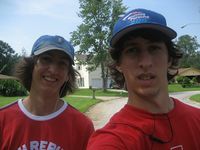
Image:2009-06-20 both.jpg | We didn't even take this photo until we were walking away. | Image:2009-06-20 both.jpg | We didn't even take this photo until we were walking away. | ||
Image:2009-06-20 drink.jpg | Chris taking a drink. | Image:2009-06-20 drink.jpg | Chris taking a drink. | ||
| − | Image:2009-06-20 cop | + | Image:2009-06-20 cop 3.jpg | There's the second cop. |
Image:2009-06-20 hill.jpg | This hill on Moody sucked. | Image:2009-06-20 hill.jpg | This hill on Moody sucked. | ||
Image:2009-06-20 c tracks.jpg | The special Tron shortcut. | Image:2009-06-20 c tracks.jpg | The special Tron shortcut. | ||
| Line 45: | Line 52: | ||
{{land geohash | latitude = 30 | longitude = -81 | date = 2009-06-20 }} | {{land geohash | latitude = 30 | longitude = -81 | date = 2009-06-20 }} | ||
| − | {{Walk geohash | latitude = 30 | longitude = -81 | date = 2009-06-20 | distance = | + | {{Walk geohash | latitude = 30 | longitude = -81 | date = 2009-06-20 | distance = 3.68 mi (5.92 km) }} |
| + | {{police geohash | ||
| + | | latitude = 30 | ||
| + | | longitude = -81 | ||
| + | | date = 2009-06-20 | ||
| + | }} | ||
{{Tron | {{Tron | ||
| latitude = 30 | | latitude = 30 | ||
| longitude = -81 | | longitude = -81 | ||
| date = 2009-06-20 | | date = 2009-06-20 | ||
| − | | tracklog = | + | | tracklog = {{filepath:2009-06-20_route.jpg}} |
| possessive = their | | possessive = their | ||
| + | }} | ||
| + | {{xkcd centurion | ||
| + | | count = 6 | ||
}} | }} | ||
| Line 57: | Line 72: | ||
[[Category:Expeditions with photos]] | [[Category:Expeditions with photos]] | ||
[[Category:Coordinates reached]] | [[Category:Coordinates reached]] | ||
| + | {{location|US|FL|CY}} | ||
Latest revision as of 12:08, 19 March 2022
| Sat 20 Jun 2009 in Jacksonville: 30.1625773, -81.7251129 geohashing.info google osm bing/os kml crox |
Location
South of Kingsly in Orange Park
Participants
- Woodveil
- Chris
Plans

We were down at the Castillo de San Marcos in St. Augustine on Friday afternoon and decided to check the day's hash, in case it was on our way home. It wasn't, but since it was Friday we went ahead and checked the hashes for Saturday and Sunday. As soon as Saturday's coordinates came up on Nick's iPhone, we knew they had to be close to our Orange Park location. Once the map showed up, our hopes were confirmed. It was in Orange Park, just south of Kingsley, and on a road! Well, in someone's driveway, but we could still reach it. In fact, it was only a couple streets down from our route on Monday's hash. We immediately decided to walk to the hash, a distance we discovered after further investigation to be less than two miles.
Expedition
The Trip

With gps and iPods in tow, we set out on foot around 3:15. We'd decided to throw in a Tron achievement too, which meant walking an extra few hundred feet. We got to the point a few minutes before 4:00, and it was farther into someone's front yard than previously thought. It was actually on a doorstep. Next door a man was mowing his lawn and trying to figure out what we were doing, so we approached him and asked if we could take some pictures in his neighbor's yard. He said they weren't home but suggested we'd have to go and ask. So we went up to the house, and made the point in the process. We stood on the doorstep, nervously taking a photo of the gps and thinking up something good to say. Then we decided to just split. Either way, we had already made the point and didn't want to bother anybody. So we continued on our way, coming within about 70 feet of our route at one point, but staying sufficiently far away as to not invalidate the Tron achievement.

As it was nearly 100 degrees outside, we decided to try the water fountains at an elementary school on Moody Road when something wonderful happened. A police officer on a motorcycle pulled in. He watched us to make sure we wouldn't break anything, and we passed him later on. Chris casually said "hey."
"How's it going?" the officer responded.
Successful Police Geohash! He rode a little farther up the road and met up with another officer, and they set up a little speed trap on Moody Road. Good day to be walking. From there we unceremoniously continued home, stopping only for photos with our namesake street sign. We got home around 4:45, happy with an expedition that just kept getting better. And pitying Mr. Bow Tie for being out of town for this walking-Police-Tron geohash. And the school at which he teaches is less than two miles from the hash, so he missed that one, too. Oh well.
Photos
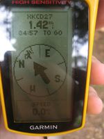
Distance from the start.
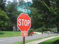
Chablis and Orange, the same Orange from Monday
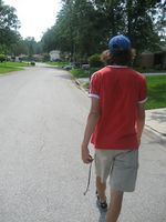
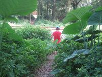
Chris walking
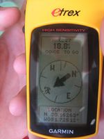
Taken while standing on the porch.
We didn't even take this photo until we were walking away.
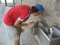
Chris taking a drink.

There's the second cop.
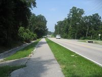
This hill on Moody sucked.
The special Tron shortcut.
Over the railroad tracks.
Finish line.


Achievements
This user earned the Land geohash achievement
|
This user earned the Walk geohash Achievement
|
This user earned the Police Geohash Achievement
|
This user earned the Tron achievement
|
This user earned the xkcd Nullaturion achievement
|