Difference between revisions of "2009-08-02 52 13"
imported>Relet (another planning page :D) |
imported>FippeBot m (Location) |
||
| (41 intermediate revisions by 14 users not shown) | |||
| Line 1: | Line 1: | ||
| − | |||
| − | |||
| − | |||
| − | |||
| − | |||
{{meetup graticule | {{meetup graticule | ||
| lat=52 | | lat=52 | ||
| Line 10: | Line 5: | ||
}} | }} | ||
| − | |||
__NOTOC__ | __NOTOC__ | ||
== Location == | == Location == | ||
| + | Just outside the front door of the Menshen factory near Spandau. http://www.menshen.com/ - They produce packaging. | ||
| + | |||
| + | [http://www.bing.com/maps/default.aspx?v=2&FORM=LMLTCP&cp=srp180j2y7t4&style=b&lvl=2&tilt=-90&dir=0&alt=-1000&phx=0&phy=0&phscl=1&scene=29714221&where1=brunsb%C3%BCtteler%20damm%20139&encType=1 bird's eye view] | ||
| + | |||
| + | Cool looking satellite dish or something just SE of the hash. -- Identified by relet as a 50s diner that should be open! http://www.cruise-in.de/ | ||
== Participants == | == Participants == | ||
| + | * [[User:davidc|davidc]] | ||
| + | * [[User:relet|relet]] | ||
== Plans == | == Plans == | ||
| + | * [[User:relet|relet]] and [[User:davidc|davidc]] meeting around 14:30 at Turmstrasse U-bahn to cycle there together | ||
| + | * Reach geohash ca. 16:00 | ||
== Expedition == | == Expedition == | ||
| + | [[User:relet|relet]] and [[User:davidc|davidc]] met in Alt-Moabit at 14:30 to cycle there together. It was davidc's first geohash outing and a year since his last serious bike ride, so we left an hour and a half to reach the hashpoint. Fortunately relet was familiar with the area and chose a beautiful route along the Spree. | ||
| + | |||
| + | We arrived at 15:25 to find the front gate closed (but not locked). There were a couple of cars parked and noise of machinery from inside. So instead of opening the gate, we remembered that the back fence had looked ungated on Google Maps, went around the back and lo! we were at the hashpoint. We had reached it from memory without GPS navigation (the screenshots were taken just for proof). | ||
| + | |||
| + | After the obligatory silly grin and proof photos we went round the back to a [http://www.cruise-in.de/ cool 50s diner] that we'd found on the satellite image - it looks like a giant dish from space, just SE of the hashpoint. Pleasantly, it was a pretty genuine replica of actual New England diners today, down to the grimy feel, nothing like the Disneyfied version on Oranienburger Strasse. We had a milkshake outside and looked up nearby geocaches on the iPhone while we waited for the official meeting time. | ||
| + | |||
| + | At 16:00 we went back around the front and, finding nobody, relet left his calling card with a note that the back gate was open. | ||
| + | |||
| + | We took a different route back through the old Spandau town centre, then headed for the [http://en.wikipedia.org/wiki/Spandau_Citadel Spandau Citadel] (''Zitadelle Spandau''), visiting geocache [http://coord.info/GCGN02 Zitadelle GCGN02], where davidc dropped off a geocoin he'd found the previous weekend, and relet explained his crazy plans to tie a rope across the citadel's moat and walk across it. | ||
| + | |||
| + | The route back was rather less scenic and more direct, heading through [http://en.wikipedia.org/wiki/Gro%C3%9Fsiedlung_Siemensstadt Siemensstadt], a neighbourhood apparently originally constructed for Siemens workers. We parted ways again in Alt-Moabit and davidc, having been given a tip by relet, finally found geocache [http://coord.info/GC10GET Kanzlerinbahn GC10GET] on the way home. | ||
== Tracklog == | == Tracklog == | ||
| + | [http://maps.google.co.uk/maps?f=d&source=s_d&saddr=Kleine+Hamburger+Stra%C3%9Fe,+Mitte+Berlin,+Germany&daddr=Hannoversche+Str.+to:Alt-Moabit+to:Unknown+road+to:Unknown+road+to:52.53314,13.235092+to:Geohash%4052.5333294,+13.1774206+to:Reformationsplatz+to:Zitadellenbr%C3%BCcke+to:Nonnendammallee+to:Siemensstra%C3%9Fe+to:Birkenstra%C3%9Fe+to:Seydlitzstra%C3%9Fe+to:Chausseestra%C3%9Fe+to:Kleine+Hamburger+Stra%C3%9Fe,+Mitte+Berlin,+Germany&hl=en&geocode=FeOCIQMde2XMAA%3BFXqEIQMdWiTMAA%3BFeZ3IQMdVKPLAA%3BFaKEIQMdgdPKAA%3BFbaJIQMdfJ_KAA%3B%3BFVGYIQMdTRLJAA%3BFTarIQMd-3zJAA%3BFbSzIQMdZJrJAA%3BFdisIQMdV-7JAA%3BFfGYIQMd-4LLAA%3BFW6PIQMdqKXLAA%3BFaiAIQMdGePLAA%3BFRqJIQMdzDrMAA%3BFeOCIQMde2XMAA&mra=dpe&mrcr=1&mrsp=5&sz=14&via=1,3,4,5,7,9,10,11,12,13&dirflg=w&sll=52.526196,13.241444&sspn=0.033838,0.069265&ie=UTF8&ll=52.540032,13.284187&spn=0.13531,0.277061&z=12 Approximate route in Google Maps], minus the river path. ca 37km round trip | ||
== Photos == | == Photos == | ||
| − | <gallery | + | <gallery> |
| − | Image: | + | Image:200908025213-P1040450.JPG | It's a gate! |
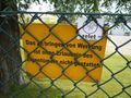
| − | Image: | + | Image:200908025213-P1040451.JPG | The sign says "access forbidden to people foreign to the company". The one you can't see inside says "guest parking". |
| + | Image:200908025213-P1040456.JPG | So, we assumed (correctly) that "guests" had to enter by another gate. | ||
| + | Image:200908025213-IMG_0066.JPG | The visitor's gate | ||
| + | Image:200908025213-P1040453.JPG | Stupid grin | ||
| + | Image:200908025213-IMG_0064.JPG | The hashpoint | ||
| + | Image:200908025213-P1040454.JPG | They have a garden pond, including false herons | ||
| + | Image:200908025213-P1040455.JPG | Meant to be a coordinate shot, more like a stupid grin, really. | ||
| + | Image:200908025213-IMG_0061.PNG | GPS screenshot | ||
| + | Image:200908025213-IMG_0062.PNG | Map screenshot, we're really on the pin though | ||
| + | Image:200908025213-IMG_0069.JPG | Cruise-In 50s Diner | ||
| + | Image:200908025213-P1040457.JPG | Inside the diner | ||
| + | Image:200908025213-P1040458.JPG | The Lions Club was here, too. | ||
| + | Image:200908025213-P1040459.JPG | We left a card at 4pm (telling people to check around the back) (It's not advertising, is it?) | ||
| + | Image:200908025213-P1040462.JPG | A villa on the way back. | ||
</gallery> | </gallery> | ||
| − | + | == Ribbons == | |
| − | + | ||
| − | + | {{land geohash|name=davidc|latitude=52|longitude=13|date=2009-08-02}} | |
| − | -- | + | {{Bicycle geohash|latitude=52|longitude=13|date=2009-08-02|name=davidc|distance=37km}} |
| − | |||
| − | |||
| − | |||
[[Category:Expeditions]] | [[Category:Expeditions]] | ||
| + | [[Category:Expedition without GPS]] | ||
[[Category:Expeditions with photos]] | [[Category:Expeditions with photos]] | ||
| − | |||
| − | |||
| − | |||
| − | |||
| − | |||
[[Category:Coordinates reached]] | [[Category:Coordinates reached]] | ||
| − | + | {{location|DE|BE}} | |
| − | |||
| − | |||
| − | |||
| − | |||
| − | |||
| − | |||
| − | |||
| − | |||
| − | |||
Latest revision as of 04:58, 8 August 2019
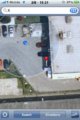
| Sun 2 Aug 2009 in 52,13: 52.5333294, 13.1774206 geohashing.info google osm bing/os kml crox |
Location
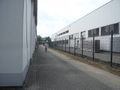
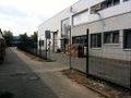
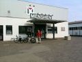
Just outside the front door of the Menshen factory near Spandau. http://www.menshen.com/ - They produce packaging.
Cool looking satellite dish or something just SE of the hash. -- Identified by relet as a 50s diner that should be open! http://www.cruise-in.de/
Participants
Plans
- relet and davidc meeting around 14:30 at Turmstrasse U-bahn to cycle there together
- Reach geohash ca. 16:00
Expedition
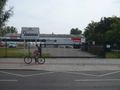
relet and davidc met in Alt-Moabit at 14:30 to cycle there together. It was davidc's first geohash outing and a year since his last serious bike ride, so we left an hour and a half to reach the hashpoint. Fortunately relet was familiar with the area and chose a beautiful route along the Spree.
We arrived at 15:25 to find the front gate closed (but not locked). There were a couple of cars parked and noise of machinery from inside. So instead of opening the gate, we remembered that the back fence had looked ungated on Google Maps, went around the back and lo! we were at the hashpoint. We had reached it from memory without GPS navigation (the screenshots were taken just for proof).
After the obligatory silly grin and proof photos we went round the back to a cool 50s diner that we'd found on the satellite image - it looks like a giant dish from space, just SE of the hashpoint. Pleasantly, it was a pretty genuine replica of actual New England diners today, down to the grimy feel, nothing like the Disneyfied version on Oranienburger Strasse. We had a milkshake outside and looked up nearby geocaches on the iPhone while we waited for the official meeting time.
At 16:00 we went back around the front and, finding nobody, relet left his calling card with a note that the back gate was open.
We took a different route back through the old Spandau town centre, then headed for the Spandau Citadel (Zitadelle Spandau), visiting geocache Zitadelle GCGN02, where davidc dropped off a geocoin he'd found the previous weekend, and relet explained his crazy plans to tie a rope across the citadel's moat and walk across it.
The route back was rather less scenic and more direct, heading through Siemensstadt, a neighbourhood apparently originally constructed for Siemens workers. We parted ways again in Alt-Moabit and davidc, having been given a tip by relet, finally found geocache Kanzlerinbahn GC10GET on the way home.
Tracklog
Approximate route in Google Maps, minus the river path. ca 37km round trip
Photos
It's a gate!
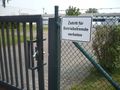
The sign says "access forbidden to people foreign to the company". The one you can't see inside says "guest parking".
So, we assumed (correctly) that "guests" had to enter by another gate.
The visitor's gate
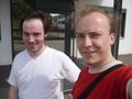
Stupid grin
The hashpoint
They have a garden pond, including false herons

Meant to be a coordinate shot, more like a stupid grin, really.
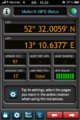
GPS screenshot
Map screenshot, we're really on the pin though
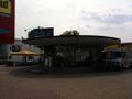
Cruise-In 50s Diner
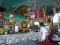
Inside the diner
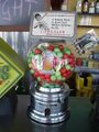
The Lions Club was here, too.
We left a card at 4pm (telling people to check around the back) (It's not advertising, is it?)
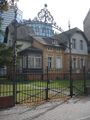
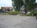
A villa on the way back.


Ribbons
davidc earned the Land geohash achievement
|
davidc earned the Bicycle geohash achievement
|