Difference between revisions of "2009-08-11 48 8"
imported>Koepfel (New page: {{meetup graticule | lat=48 | lon=8 | date=2009-08-11 }} == Location == In a forest near Spielberg, a part of the municipality of Karlsbad|. Spielberg is ...) |
imported>FippeBot m (Location) |
||
| (4 intermediate revisions by one other user not shown) | |||
| Line 7: | Line 7: | ||
== Location == | == Location == | ||
| − | In a forest near Spielberg, a part of the municipality of [[Wikipedia:Karlsbad_(Baden)|Karlsbad | + | In a forest near Spielberg, a part of the municipality of [[Wikipedia:Karlsbad_(Baden)|Karlsbad]]. Spielberg is connected to the [[Wikipedia:Albtalbahn|Albtalbahn]], line S11. It is only about 4 kilometers away from [[2009-08-10 48 8|yesterday's hashpoint]].. |
== Participants == | == Participants == | ||
| Line 21: | Line 21: | ||
From Spielberg, it's about one kilometer by foot to the Hashpoint. | From Spielberg, it's about one kilometer by foot to the Hashpoint. | ||
| − | |||
== Expedition by [[User:Koepfel|Koepfel]] == | == Expedition by [[User:Koepfel|Koepfel]] == | ||
| − | |||
=== Report === | === Report === | ||
| + | As on [[2009-08-10 48 8|yesterday's]] expedition, I used the Albtalbahn to reach the Hashpoint. Also as yesterday, I arrived at the stop Ettlinger Tor 20 minutes too early, as yesterday. After waiting the first 10 minutes, I was tired of standing at a noisy stop in the middle of the road, so I took the 13:52 S1 to wait the remaining 10 minutes in Ettlingen. There, I arrived at 14:14. After walking around in [http://geohash.koepfel.de/2009-08-11_48_8/pages/page_4.html Ettlingen] for a few minutes, I realized that 10 minutes were a shorter timespan than I expected and I hurried back to the station to catch the [http://geohash.koepfel.de/2009-08-11_48_8/pages/page_5.html S11] to Ittersbach. At 14:40, I arrived in [http://geohash.koepfel.de/2009-08-11_48_8/pages/page_7.html Spielberg]. | ||
| + | |||
| + | Leavin Spielberg, I walked the one kilometer to the Hashpoint through the fields. A hundred meters from the hashpoint, I came by this [http://geohash.koepfel.de/2009-08-11_48_8/pages/page_12.html barbecue area]. As I didn't have anything [[Picnic_achievement|to eat]] with me, I continued to the Hashpoint (I later found out the grill was also locked). | ||
| + | |||
| + | As opposed to the satellite imagery, which put the Hashpoint in the forest, the [http://geohash.koepfel.de/2009-08-11_48_8/pages/page_13.html GPS] said: On the grass, next to the field. I started with the chalk marker, but as it began to drizzle, I changed my mind to a paper marker. Not that it would hold that much longer, it it would have started to rain, but meh. | ||
| + | |||
| + | As I had about 30 minutes, until the next train would go back to Karlsruhe, I returned to the barbecue area and rested there. After a few minutes, I returned to Spielberg, where I took the 15:30 [http://geohash.koepfel.de/2009-08-11_48_8/pages/page_26.html S11] home. | ||
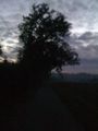
<gallery> | <gallery> | ||
| + | Image:2009-08-11 48 8-hash.jpg|Reached | ||
| + | Image:2009-08-11 48 8-hashtree.jpg|Hash Tree | ||
| + | Image:2009-08-11 48 8-valley.jpg|Not the weather you would expect in the middle of August | ||
| + | Image:2009-08-11 48 8-grill.jpg|No Picnic Geohash for me | ||
| + | Image:2009-10-22 48 8-revisit.jpg|Revisited in the early morning during [[2009-10-22 48 8]] | ||
| + | </gallery> | ||
| + | [http://geohash.koepfel.de/2009-08-11_48_8 (more pictures)] | ||
| − | |||
| − | |||
[[Category:Expeditions with photos]] | [[Category:Expeditions with photos]] | ||
[[Category:Expeditions]] | [[Category:Expeditions]] | ||
| − | [[Category:Coordinates reached]] | + | [[Category:Coordinates reached]] |
| − | + | {{location|DE|BW|KA}} | |
Latest revision as of 05:08, 8 August 2019
| Tue 11 Aug 2009 in 48,8: 48.8933175, 8.4837397 geohashing.info google osm bing/os kml crox |
Location
In a forest near Spielberg, a part of the municipality of Karlsbad. Spielberg is connected to the Albtalbahn, line S11. It is only about 4 kilometers away from yesterday's hashpoint..
Participants
Plans
Just as yesterday, this hashpoint can be easily reached with the Albtalbahn.
The S11 is leaving from Karlsruhe Ettlinger Tor at 14:02 arrives in Spielberg at 14:39.
From Spielberg, it's about one kilometer by foot to the Hashpoint.
Expedition by Koepfel
Report
As on yesterday's expedition, I used the Albtalbahn to reach the Hashpoint. Also as yesterday, I arrived at the stop Ettlinger Tor 20 minutes too early, as yesterday. After waiting the first 10 minutes, I was tired of standing at a noisy stop in the middle of the road, so I took the 13:52 S1 to wait the remaining 10 minutes in Ettlingen. There, I arrived at 14:14. After walking around in Ettlingen for a few minutes, I realized that 10 minutes were a shorter timespan than I expected and I hurried back to the station to catch the S11 to Ittersbach. At 14:40, I arrived in Spielberg.
Leavin Spielberg, I walked the one kilometer to the Hashpoint through the fields. A hundred meters from the hashpoint, I came by this barbecue area. As I didn't have anything to eat with me, I continued to the Hashpoint (I later found out the grill was also locked).
As opposed to the satellite imagery, which put the Hashpoint in the forest, the GPS said: On the grass, next to the field. I started with the chalk marker, but as it began to drizzle, I changed my mind to a paper marker. Not that it would hold that much longer, it it would have started to rain, but meh.
As I had about 30 minutes, until the next train would go back to Karlsruhe, I returned to the barbecue area and rested there. After a few minutes, I returned to Spielberg, where I took the 15:30 S11 home.
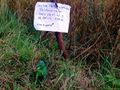
Reached
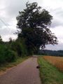
Hash Tree
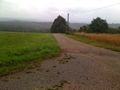
Not the weather you would expect in the middle of August
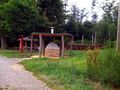
No Picnic Geohash for me
Revisited in the early morning during 2009-10-22 48 8


