Difference between revisions of "2009-09-30 52 -1"
imported>Davidc |
imported>FippeBot m (Location) |
||
| (4 intermediate revisions by one other user not shown) | |||
| Line 15: | Line 15: | ||
== Expedition == | == Expedition == | ||
| + | |||
| + | Leaving Herefordshire, it was clear I couldn't make the [[2009-09-30 52 -0|52,-0 meetup]] in time, so I headed east towards Banbury for this hash. It was a gorgeous drive across the beautiful English countryside and I was now in no hurry. [[:Image:2009-09-30_52_-1_IMG_1778-1783_panorama2.jpg|This]] is why I keep coming back to England. And was Jerusalem builded here? | ||
| + | |||
| + | I parked at a severe angle on the hill and found a public footpath toward the hashpoint. It led to a field containing two (2) friendly hash-horses. I needed the next field along. I walked the entire edge of the field and found no way through except for one corner, where there was a gap, but a temporarily erected electric fence blocked access. Figuring the farmer must just be ignoring my statutory right of way, I ducked under the fence and into the next field. Dodging large lumps of dried hash-poo, I reached the far corner and the hashpoint. | ||
| + | |||
| + | My camera was almost completely dead at this point so there are only a few photos. I was so hungry I almost ate rabbitfox, but fortunately I found some hashberries on the way back to the car. | ||
| + | |||
| + | Of possible interest to other geohashers, I discovered that if you park your hash-car at a cute angle, the tank will miraculously fill up with hash-fuel. It's magical hash-fuel though, and it only lasts around half an hour before evaporating. | ||
| + | |||
| + | My two day circular hash tour complete, I headed back to Surrey. | ||
{{davidc/Autumn_2009_series}} | {{davidc/Autumn_2009_series}} | ||
| − | == Photos == | + | == Photos == |
<gallery perrow="4"> | <gallery perrow="4"> | ||
| + | Image:2009-09-30_52_-1_IMG_1778-1783_panorama2.jpg|Splendid panorama containing the hashfield. | ||
| + | Image:2009-09-30_52_-1_IMG_1785.JPG|Coordinates reached! | ||
| + | Image:2009-09-30_52_-1_IMG_1789.JPG|I was so hungry I almost ate rabbitfox... | ||
| + | Image:2009-09-30_52_-1_IMG_1791.JPG|... but fortunately there were some hash-berries nearby. | ||
| + | Image:2009-09-30_52_-1_IMG_1792.JPG|If you park your hash-car at a cute angle... | ||
| + | Image:2009-09-30_52_-1_IMG_1793.JPG|... you get a free tank of magical hash-fuel! | ||
| + | </gallery> | ||
| + | |||
| + | == Ribbons == | ||
| − | + | {{Multihash | |
| + | | latitude1 = 52 | ||
| + | | longitude1 = -2 | ||
| + | | latitude2 = 52 | ||
| + | | longitude2 = -1 | ||
| + | | date = 2009-09-30 | ||
| + | | name = [[User:davidc|davidc]] | ||
| + | }} | ||
| + | {{Minesweeper geohash | graticule = 51,-1 | ranknumber = 3 | s = true | nw = true | n = true | name = [[User:Davidc|davidc]]}} | ||
[[Category:Expeditions]] | [[Category:Expeditions]] | ||
[[Category:Expeditions with photos]] | [[Category:Expeditions with photos]] | ||
| − | |||
[[Category:Coordinates reached]] | [[Category:Coordinates reached]] | ||
| + | {{location|GB|ENG|OXF}} | ||
Latest revision as of 06:05, 8 August 2019
| Wed 30 Sep 2009 in 52,-1: 52.0357456, -1.4944536 geohashing.info google osm bing/os kml crox |
Location
A field in Sibford Gower, near Banbury.
Participants
Expedition
Leaving Herefordshire, it was clear I couldn't make the 52,-0 meetup in time, so I headed east towards Banbury for this hash. It was a gorgeous drive across the beautiful English countryside and I was now in no hurry. This is why I keep coming back to England. And was Jerusalem builded here?
I parked at a severe angle on the hill and found a public footpath toward the hashpoint. It led to a field containing two (2) friendly hash-horses. I needed the next field along. I walked the entire edge of the field and found no way through except for one corner, where there was a gap, but a temporarily erected electric fence blocked access. Figuring the farmer must just be ignoring my statutory right of way, I ducked under the fence and into the next field. Dodging large lumps of dried hash-poo, I reached the far corner and the hashpoint.
My camera was almost completely dead at this point so there are only a few photos. I was so hungry I almost ate rabbitfox, but fortunately I found some hashberries on the way back to the car.
Of possible interest to other geohashers, I discovered that if you park your hash-car at a cute angle, the tank will miraculously fill up with hash-fuel. It's magical hash-fuel though, and it only lasts around half an hour before evaporating.
My two day circular hash tour complete, I headed back to Surrey.
This geohash was part of davidc's European tour in Autumn 2009:
England:
- 2009-09-27 50 -1 - Eastleigh, Hampshire.
- 2009-09-29 51 -0 - Stoke D'Abernon, Surrey (Failed: No Public Access)
- 1978-11-27 51 -0 on 2009-09-29 - my Origin Geohash in Bramley, Surrey.
- 2009-09-29 51 -1 - Ashmansworth. Speed racer!
- 2009-09-30 52 -2 - Herefordshire. Virgin graticule!
- 2009-09-30 52 -1 - Sibford Gower, Oxfordshire.
- 2009-10-01 51 -0 - Reigate, Surrey (Failed Ambassador)
Portugal:
- 2009-10-07 38 -9 - Cabo Espichel, Sesimbra
Photos
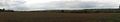
Splendid panorama containing the hashfield.
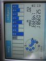
Coordinates reached!

I was so hungry I almost ate rabbitfox...
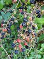
... but fortunately there were some hash-berries nearby.
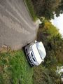
If you park your hash-car at a cute angle...

... you get a free tank of magical hash-fuel!


Ribbons
davidc earned the Multihash Achievement
|
davidc achieved level 3 of the Minesweeper Geohash achievement
|