Difference between revisions of "2009-10-18 51 -2"
imported>Macronencer (New page: {{subst:Expedition |lat = 51 |lon = -2 |date = 2009-10-18 }}) |
m (Location correction) |
||
| (4 intermediate revisions by 2 users not shown) | |||
| Line 1: | Line 1: | ||
| − | |||
<!-- If you did not specify these parameters in the template, please substitute appropriate things for IMAGE, LAT, LON, and DATE (YYYY-MM-DD format) --> | <!-- If you did not specify these parameters in the template, please substitute appropriate things for IMAGE, LAT, LON, and DATE (YYYY-MM-DD format) --> | ||
<!-- | <!-- | ||
| Line 13: | Line 12: | ||
__NOTOC__ | __NOTOC__ | ||
== Location == | == Location == | ||
| − | + | [http://maps.google.com/?ie=UTF8&q=loc:51.49453736331687,-2.289425774013368&hq=&hnear=&ll=51.494537,-2.289426&spn=0.005244,0.012048&t=h&z=17 West Kington, Chippenham] | |
== Participants == | == Participants == | ||
| − | + | [[User:Macronencer|Macronencer]] | |
== Plans == | == Plans == | ||
| + | Impromptu! | ||
== Expedition == | == Expedition == | ||
| + | Having finished my [[2009-10-18 51 -3|Cardiff hash]] I wanted to press on to Bristol graticule as soon as I could to collect my Minesweeper point. The first thing that happened, of course, was a massive traffic jam around Cardiff :| In the end I reached the Bristol hash with about 20 minutes of good daylight left, which was just enough! | ||
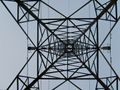
| + | This location was in a field that had been harvested a while ago and still had stubble. There was a power line running across it. I parked close by and walked through a gap by the gate. It was quite easy to reach the hash. I walked back, and noticed a Land Rover slowing down as it passed on the road. Perhaps someone had seen me and was going to give me a grilling! I would have said I was taking artistic photos of the pylon (actually I had done this!) but in the event they didn't bother. I wasn't doing any harm anyway: there was clearly nothing growing in the field and nothing sown. | ||
| − | + | So, this together with the Cardiff hash made my second [[Multihash]]. | |
== Photos == | == Photos == | ||
| − | |||
| − | |||
| − | |||
| − | |||
| − | |||
<gallery perrow="4"> | <gallery perrow="4"> | ||
| − | + | Image:2009-10-18_51_-2_Macronencer_01.jpg | Parked with less than an hour of light left! | |
| + | Image:2009-10-18_51_-2_Macronencer_02.jpg | Hash field | ||
| + | Image:2009-10-18_51_-2_Macronencer_03.jpg | Co-ordinates reached! | ||
| + | Image:2009-10-18_51_-2_Macronencer_04.jpg | Stubble in the field. Note mud from Cardiff! | ||
| + | Image:2009-10-18_51_-2_Macronencer_05.jpg | Stupid grin! | ||
| + | Image:2009-10-18_51_-2_Macronencer_06.jpg | Pylon | ||
| + | Image:2009-10-18_51_-2_Macronencer_07.jpg | | ||
</gallery> | </gallery> | ||
| + | == Achivements == | ||
| − | < | + | {{Minesweeper geohash |
| − | + | | graticule = Swindon, United Kingdom | |
| − | + | | ranknumber = 5 | |
| − | -- | + | | e = true |
| + | | se = true | ||
| + | | s = true | ||
| + | | sw = true | ||
| + | | w = true | ||
| + | | name = Macronencer | ||
| + | }} | ||
| + | <br/> | ||
| + | |||
| + | {{Multihash | latitude1 = 51 | longitude1 = -3 | latitude2 = 51 | longitude2 = -2 | date = 2009-10-18 | name = Macronencer }} | ||
| − | |||
[[Category:Expeditions]] | [[Category:Expeditions]] | ||
| − | |||
[[Category:Expeditions with photos]] | [[Category:Expeditions with photos]] | ||
| − | |||
| − | |||
| − | |||
| − | |||
| − | |||
[[Category:Coordinates reached]] | [[Category:Coordinates reached]] | ||
| − | + | {{location|GB|ENG|WIL}} | |
| − | |||
| − | |||
| − | |||
| − | |||
| − | |||
| − | |||
| − | |||
| − | |||
| − | |||
Latest revision as of 19:58, 16 May 2020
| Sun 18 Oct 2009 in 51,-2: 51.4945374, -2.2894258 geohashing.info google osm bing/os kml crox |
Location
Participants
Plans
Impromptu!
Expedition
Having finished my Cardiff hash I wanted to press on to Bristol graticule as soon as I could to collect my Minesweeper point. The first thing that happened, of course, was a massive traffic jam around Cardiff :| In the end I reached the Bristol hash with about 20 minutes of good daylight left, which was just enough!
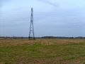
This location was in a field that had been harvested a while ago and still had stubble. There was a power line running across it. I parked close by and walked through a gap by the gate. It was quite easy to reach the hash. I walked back, and noticed a Land Rover slowing down as it passed on the road. Perhaps someone had seen me and was going to give me a grilling! I would have said I was taking artistic photos of the pylon (actually I had done this!) but in the event they didn't bother. I wasn't doing any harm anyway: there was clearly nothing growing in the field and nothing sown.
So, this together with the Cardiff hash made my second Multihash.
Photos
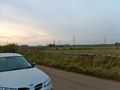
Parked with less than an hour of light left!
Hash field
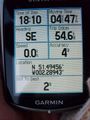
Co-ordinates reached!
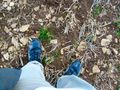
Stubble in the field. Note mud from Cardiff!
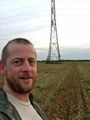
Stupid grin!
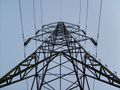
Pylon


Achivements
Macronencer achieved level 5 of the Minesweeper Geohash achievement
|
Macronencer earned the Multihash Achievement
|