Difference between revisions of "2009-12-06 45 -122"
imported>Jiml m (Add a few details) |
imported>FippeBot m (Location) |
||
| (12 intermediate revisions by 4 users not shown) | |||
| Line 7: | Line 7: | ||
== Location == | == Location == | ||
| − | Beaverton, Oregon. Sunset High School | + | Beaverton, Oregon. The Sunset High School baseball field. |
== Participants == | == Participants == | ||
| − | * Jim | + | * [[User:Jiml|Jim]] |
| − | * APR | + | * [[User:Aperfectring|APR]] |
| + | * [[User:Michael5000|Michael5000]] | ||
== Plans == | == Plans == | ||
| + | |||
| + | We all believe that it should be open to the public, and | ||
| + | there shouldn't be any problems with activity on the field on a freezing cold Sunday.... | ||
| + | |||
| + | |||
Jim's thinking of heading there for the meetup time, which he thinks we've shifted to 2PM for the winter. | Jim's thinking of heading there for the meetup time, which he thinks we've shifted to 2PM for the winter. | ||
| − | + | Michael5000 is going to build this into a holiday shopping run, and will attempt the site (pretty confidently, this time) between 9:30 and 10:30. I'll try to leave some evidence for later arrivals! | |
| + | |||
| + | I'll leave so that I get there about 2. --[[User:Aperfectring|aperfectring]] 19:24, 6 December 2009 (UTC) | ||
| + | |||
| + | |||
| + | == Expeditions == | ||
| − | + | ===michael5000's Expedition=== | |
| − | + | In between some other errands, I pulled into the Sunset High School baseball field's parking lot sometime around ten o'clock. I got out of the truck, went through a gate, and walked over to the hash point. I stuck a small flag at the approximate site. I thought briefly about the year I spent student teaching at Sunset. I shrugged, went back to the truck, and continued my errands! | |
| + | ===Aperfectring's Expedition=== | ||
| − | == | + | I looked at the location on Friday, and saw that it was a perfect location to attempt a bike ride. Knowing that I am very much not in shape, and having looked at the weather (1C/34F high for the day), I decided to look at a hybrid train/bike hash. I rode the Blue line down to Sunset Transit Center, and biked from there down Barnes to Cornell, then to Sunset High School. I pulled my bike through the gate, and up to the first base side dugout, when I called Jiml to see if he was nearby. I noticed the flag out in the infield, but didn't think of it being a marker initially. I thought it was probably just a fertilizer flag left in. As I closed in on the coords, I correctly identified it as a potential hash marker left by a previous geohasher, presumably Michael5000, since he was the only one who had expressed interest. I took a few pictures and got on a warm hat while I waited for Jim to arrive. |
| + | |||
| + | On the way back, I realized just how easy I had it on the way towards the hashpoint. I was headed mostly downhill with a heavy tailwind on the way, that means that on the way back, I was headed uphill with a heavy headwind. Looking it up after I got home, I find that the winds are 20mph (32km/hr) sustained. Given that it was pretty much 1C/34F at the time, that makes the wind chill (what it feels like with the wind) -4.5C/24F. Given these two things, I don't feel so bad about not being able to bike back up those hills on the way back. Total biked distance ~7km, walked ~1km. Since I didn't travel the whole way by bike/foot, I won't take those two ribbons, but I will take the public transit one. | ||
| + | |||
| + | ===Jim's Expedition=== | ||
| + | |||
| + | I set out from home, but didn't bother to print out anything. I had been in that area a number of times before. | ||
| + | I got there and found the aforementioned gate and once I wandered on the field, I saw APR. We exchanged greetings and | ||
| + | photos and picked up the marker left by Michael5000, not wishing to upset the baseball team. | ||
| + | |||
| + | And we headed off in our own directions. | ||
== Photos == | == Photos == | ||
| − | + | ||
| + | I don't know why the photos are so pink. I tried to adjust them, but wasn't completely successful. | ||
| + | |||
<gallery perrow="4"> | <gallery perrow="4"> | ||
| − | |||
| − | |||
| − | |||
| − | |||
| + | Image:2009-12-06 45 -122-site.jpg | A view of the hashpoint area | ||
| + | Image:2009-12-06 45 -122-marker.jpg | The marker | ||
| − | |||
| − | |||
| − | + | </gallery> | |
| − | <!-- | + | Not so pink photos |
| − | [[Category:Expeditions]] | + | <gallery perrow="4"> |
| − | + | Image:2009-12-06 45 -122 apr 01.JPG | The previous marker | |
| + | Image:2009-12-06 45 -122 apr 03.JPG | Proof of coordinates reached! | ||
| + | Image:2009-12-06 45 -122 apr 05.JPG | A tired, and chilly aperfectring at the dugout nearby | ||
| + | Image:2009-12-06 45 -122 apr 06.JPG | A happy aperfectring at the hashpoint | ||
| + | Image:2009-12-06 45 -122 apr 07.JPG | Jim at the hashpoint | ||
| + | Image:2009-12-06 45 -122 apr 08.JPG | The new, less stick in the mud, marker | ||
| + | </gallery> | ||
| + | |||
| + | [[Category:Expeditions]][[Category:Coordinates reached]] | ||
[[Category:Expeditions with photos]] | [[Category:Expeditions with photos]] | ||
| − | + | {{location|US|OR|WI}} | |
| − | |||
| − | |||
| − | |||
| − | |||
| − | |||
| − | |||
| − | |||
| − | |||
| − | |||
| − | |||
| − | |||
| − | |||
| − | |||
| − | |||
| − | |||
| − | |||
| − | |||
Latest revision as of 00:04, 9 August 2019
| Sun 6 Dec 2009 in 45,-122: 45.5292116, -122.8216196 geohashing.info google osm bing/os kml crox |
Contents
Location
Beaverton, Oregon. The Sunset High School baseball field.
Participants
Plans
We all believe that it should be open to the public, and there shouldn't be any problems with activity on the field on a freezing cold Sunday....
Jim's thinking of heading there for the meetup time, which he thinks we've shifted to 2PM for the winter.
Michael5000 is going to build this into a holiday shopping run, and will attempt the site (pretty confidently, this time) between 9:30 and 10:30. I'll try to leave some evidence for later arrivals!
I'll leave so that I get there about 2. --aperfectring 19:24, 6 December 2009 (UTC)
Expeditions
michael5000's Expedition
In between some other errands, I pulled into the Sunset High School baseball field's parking lot sometime around ten o'clock. I got out of the truck, went through a gate, and walked over to the hash point. I stuck a small flag at the approximate site. I thought briefly about the year I spent student teaching at Sunset. I shrugged, went back to the truck, and continued my errands!
Aperfectring's Expedition
I looked at the location on Friday, and saw that it was a perfect location to attempt a bike ride. Knowing that I am very much not in shape, and having looked at the weather (1C/34F high for the day), I decided to look at a hybrid train/bike hash. I rode the Blue line down to Sunset Transit Center, and biked from there down Barnes to Cornell, then to Sunset High School. I pulled my bike through the gate, and up to the first base side dugout, when I called Jiml to see if he was nearby. I noticed the flag out in the infield, but didn't think of it being a marker initially. I thought it was probably just a fertilizer flag left in. As I closed in on the coords, I correctly identified it as a potential hash marker left by a previous geohasher, presumably Michael5000, since he was the only one who had expressed interest. I took a few pictures and got on a warm hat while I waited for Jim to arrive.
On the way back, I realized just how easy I had it on the way towards the hashpoint. I was headed mostly downhill with a heavy tailwind on the way, that means that on the way back, I was headed uphill with a heavy headwind. Looking it up after I got home, I find that the winds are 20mph (32km/hr) sustained. Given that it was pretty much 1C/34F at the time, that makes the wind chill (what it feels like with the wind) -4.5C/24F. Given these two things, I don't feel so bad about not being able to bike back up those hills on the way back. Total biked distance ~7km, walked ~1km. Since I didn't travel the whole way by bike/foot, I won't take those two ribbons, but I will take the public transit one.
Jim's Expedition
I set out from home, but didn't bother to print out anything. I had been in that area a number of times before. I got there and found the aforementioned gate and once I wandered on the field, I saw APR. We exchanged greetings and photos and picked up the marker left by Michael5000, not wishing to upset the baseball team.
And we headed off in our own directions.
Photos
I don't know why the photos are so pink. I tried to adjust them, but wasn't completely successful.
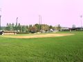
A view of the hashpoint area
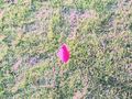
The marker


Not so pink photos
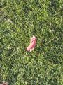
The previous marker
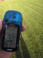
Proof of coordinates reached!

A tired, and chilly aperfectring at the dugout nearby
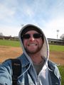
A happy aperfectring at the hashpoint
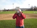
Jim at the hashpoint
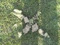
The new, less stick in the mud, marker


