Difference between revisions of "2009-12-28 52 13"
From Geohashing
imported>Relet (Created page with '{{subst:Expedition|lat=52|lon=13|date=2009-12-28}}') |
imported>FippeBot m (Location) |
||
| (6 intermediate revisions by 2 users not shown) | |||
| Line 1: | Line 1: | ||
| − | |||
| − | |||
| − | |||
| − | |||
| − | |||
{{meetup graticule | {{meetup graticule | ||
| lat=52 | | lat=52 | ||
| Line 14: | Line 9: | ||
== Location == | == Location == | ||
| + | A forest near Hennigsdorf. | ||
== Participants == | == Participants == | ||
| + | * [[User:relet|relet]] | ||
== Plans == | == Plans == | ||
| + | ETA 13:00 | ||
== Expedition == | == Expedition == | ||
| + | There's again not much to say. I drove by before starting my day of shopping. I walked for about a kilometer into the cold, damp forest, before dancing a particularly difficult GPS appeasement dance (It was clouded, rainy and in a forest). Eventually, the phone decided to relieve me from my poor performance by increasing the inaccuracy. | ||
== Tracklog == | == Tracklog == | ||
| Line 29: | Line 28: | ||
== Photos == | == Photos == | ||
| − | |||
<gallery perrow="4"> | <gallery perrow="4"> | ||
| − | + | File:200912285213-P1050418.JPG | It was a cold, damp forest... | |
| − | + | File:200912285213-P1050419.JPG | ...excelling in dampness. | |
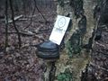
| + | File:200912285213-P1050420.JPG | Maybe the most interesting find: A traffic sign with bullet holes. | ||
| + | File:200912285213-P1050425.JPG | Coredinates damped | ||
| + | File:200912285213-P1050426.JPG | A stupid grin... | ||
| + | File:200912285213-P1050427.JPG | ...and a stupid card. What more could you want? | ||
</gallery> | </gallery> | ||
| − | |||
| − | |||
| − | |||
| − | |||
| − | |||
| − | |||
| − | |||
| − | |||
| − | |||
| − | |||
| − | |||
[[Category:Expeditions]] | [[Category:Expeditions]] | ||
| − | |||
[[Category:Expeditions with photos]] | [[Category:Expeditions with photos]] | ||
| − | |||
| − | |||
| − | |||
| − | |||
| − | |||
[[Category:Coordinates reached]] | [[Category:Coordinates reached]] | ||
| − | + | {{location|DE|BB|OHV}} | |
| − | |||
| − | |||
| − | |||
| − | |||
| − | |||
| − | |||
| − | |||
| − | |||
| − | |||
Latest revision as of 00:18, 9 August 2019
| Mon 28 Dec 2009 in 52,13: 52.5974210, 13.1827508 geohashing.info google osm bing/os kml crox |
Location
A forest near Hennigsdorf.
Participants
Plans
ETA 13:00
Expedition
There's again not much to say. I drove by before starting my day of shopping. I walked for about a kilometer into the cold, damp forest, before dancing a particularly difficult GPS appeasement dance (It was clouded, rainy and in a forest). Eventually, the phone decided to relieve me from my poor performance by increasing the inaccuracy.
Tracklog
Photos
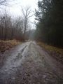
It was a cold, damp forest...
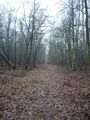
...excelling in dampness.

Maybe the most interesting find: A traffic sign with bullet holes.
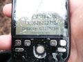
Coredinates damped

A stupid grin...
...and a stupid card. What more could you want?


