Difference between revisions of "2010-01-16 38 -122"
imported>JBQ (Expedition) |
imported>FippeBot m (Location) |
||
| (5 intermediate revisions by one other user not shown) | |||
| Line 13: | Line 13: | ||
== Expedition == | == Expedition == | ||
| − | As soon as the coordinates for the week-end became available, JBQ spotted this great Saturday point in the [[Santa_Rosa,_California|Santa Rosa] graticule. A quick lookup on Google maps suggested a 2-hour drive from home, for barely more than 75 miles one-way. | + | As soon as the coordinates for the week-end became available, JBQ spotted this great Saturday point in the [[Santa_Rosa,_California|Santa Rosa]] graticule. A quick lookup on Google maps suggested a 2-hour drive from home, for barely more than 75 miles one-way. |
Checking the weather forecast on the morning of the expedition, things weren't looking good for a 4pm meetup, with a forecast of rain through all afternoon. JBQ figured out that going in the morning would make more sense. Unfortunately he absolutely needed to go to a post office to send a package, which meant that he had to wait until a post office actually opened close to home. This turned out to be 8:30 in Belmont. | Checking the weather forecast on the morning of the expedition, things weren't looking good for a 4pm meetup, with a forecast of rain through all afternoon. JBQ figured out that going in the morning would make more sense. Unfortunately he absolutely needed to go to a post office to send a package, which meant that he had to wait until a post office actually opened close to home. This turned out to be 8:30 in Belmont. | ||
| Line 19: | Line 19: | ||
Since JBQ's wife couldn't be convinced to come along (thereby missing a [[Drag-along_achievement|drag-along achievement]]), it was necessary to be back home for lunch. That made for a tight schedule, but at least going to the post office before going to the geohash meant that there was no hard schedule requirement while geohashing (other than avoid starvation). In retrospect, there'd have been other options, since there's a post office in San Francisco that opens at 8am on Saturdays, and another one that stays open until 4pm. | Since JBQ's wife couldn't be convinced to come along (thereby missing a [[Drag-along_achievement|drag-along achievement]]), it was necessary to be back home for lunch. That made for a tight schedule, but at least going to the post office before going to the geohash meant that there was no hard schedule requirement while geohashing (other than avoid starvation). In retrospect, there'd have been other options, since there's a post office in San Francisco that opens at 8am on Saturdays, and another one that stays open until 4pm. | ||
| − | Anyway, at 8:45 the package had been sent and JBQ was on his way. Traffic through San Francisco and all the way to San Rafael was light. After a quick pause in San Rafael to check the route (and to discover that the Droid | + | Anyway, at 8:45 the package had been sent and JBQ was on his way. Traffic through San Francisco and all the way to San Rafael was light. After a quick pause in San Rafael to check the route (and to discover that the Droid had almost no battery left), it was time to drive the slower part of the route, i.e. mile after mile of 30, 35 and 40 mph speed limits. An boat stranded ashore in Inverness was begging to be photographed. Driving through the NPS-managed land, the landscape looked very dramatic, especially with rays of sunlight peeking through a highly textured cloud cover. Eventually, the Point Reyes Beach South parking lot was reached a bit before 11am, and the cars there could be counted on the fingers of a single hand. |
With his camera bag strapped on one shoulder, his tripod bag on the other, and a Nexus One in a pocket, it was time to walk on the beach toward the exact coordinates, less than half a mile away. An ominous sign on the parking lot reminded beachgoers that the Pacific Ocean is actually dangerous. It's unclear whether a shark bite would qualify for a [[Raptor_geohash|raptor achievement]], though. JBQ had never actually been on that specific beach, even though he had seen it a few times from the Point Reyes lighthouse area, and it is as huge in person as it seems from above. On a menacingly overcast Saturday morning in January, it was also pretty much deserted. | With his camera bag strapped on one shoulder, his tripod bag on the other, and a Nexus One in a pocket, it was time to walk on the beach toward the exact coordinates, less than half a mile away. An ominous sign on the parking lot reminded beachgoers that the Pacific Ocean is actually dangerous. It's unclear whether a shark bite would qualify for a [[Raptor_geohash|raptor achievement]], though. JBQ had never actually been on that specific beach, even though he had seen it a few times from the Point Reyes lighthouse area, and it is as huge in person as it seems from above. On a menacingly overcast Saturday morning in January, it was also pretty much deserted. | ||
| Line 32: | Line 32: | ||
== Photos == | == Photos == | ||
| − | ' | + | <gallery perrow="5"> |
| − | + | Image:2010-01-16_38_-122_parking_lot_1.jpg | 100% of cars on the south parking lot are geohashers | |
| − | + | Image:2010-01-16_38_-122_parking_lot_2.jpg | Grand total of 5 cars on the parking lot | |
| − | Image: | + | Image:2010-01-16_38_-122_dangerous_surf.jpg | "Sharks? They have sharks? Can I have one?" |
| − | Image: | + | Image:2010-01-16_38_-122_beach_1.jpg | Deserted beach looking north |
| + | Image:2010-01-16_38_-122_beach_2.jpg | Deserted beach looking south | ||
| + | Image:2010-01-16_38_-122_waves_1.jpg | Some pretty serious waves | ||
| + | Image:2010-01-16_38_-122_waves_2.jpg | Yup, I'm gonna stay on dry land | ||
| + | Image:2010-01-16_38_-122_pelicans_1.jpg | Pelicans cruising high above the waves | ||
| + | Image:2010-01-16_38_-122_pelicans_2.jpg | Pelicans inches above the water | ||
| + | Image:2010-01-16_38_-122_geotrash_before.jpg | Assorted trash in its natural habitat | ||
| + | Image:2010-01-16_38_-122_camping.jpg | Did someone try for a camping achievement? | ||
| + | Image:2010-01-16_38_-122_coordinates.jpg | Right at the spot, with a bit of cell coverage in the middle of nowhere | ||
| + | Image:2010-01-16_38_-122_at_the_spot.jpg | I was there, I swear. Does the sweater qualify for a circus achievement? | ||
| + | Image:2010-01-16_38_-122_pretty_plants.jpg | This stuff grows everywhere on the dunes, but is rarely that colorful | ||
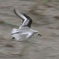
| + | Image:2010-01-16_38_-122_birds_1.jpg | Those little guys were digging for food in the sand... | ||
| + | Image:2010-01-16_38_-122_birds_2.jpg | ... and they didn't let anyone get close | ||
| + | Image:2010-01-16_38_-122_surfers.jpg | "Do you really think we should go? This looks cold!" | ||
| + | Image:2010-01-16_38_-122_geotrash_after.jpg | Trash about to go in the dumpster | ||
| + | Image:2010-01-16_38_-122_waves_3.jpg | The waves look big even from the parking lot | ||
| + | Image:2010-01-16_38_-122_boat.jpg | This boat is like a top model posing for photographers | ||
</gallery> | </gallery> | ||
| − | |||
| + | == Achievements == | ||
| + | {{land geohash | ||
| − | + | | latitude = 38 | |
| − | + | | longitude = -122 | |
| − | + | | date = 2010-01-16 | |
| − | + | | name = JBQ | |
| − | + | }} | |
| − | + | {{Geotrash | |
| − | + | ||
| − | + | | latitude = 38 | |
| + | | longitude = -122 | ||
| + | | date = 2010-01-16 | ||
| + | | name = JBQ | ||
| + | |||
| + | }} | ||
[[Category:Expeditions]] | [[Category:Expeditions]] | ||
| − | |||
[[Category:Expeditions with photos]] | [[Category:Expeditions with photos]] | ||
| − | |||
| − | |||
| − | |||
| − | |||
[[Category:Coordinates reached]] | [[Category:Coordinates reached]] | ||
| − | + | {{location|US|CA|MN}} | |
| − | |||
| − | |||
| − | |||
| − | |||
| − | |||
| − | |||
| − | |||
| − | |||
Latest revision as of 00:30, 9 August 2019
| Sat 16 Jan 2010 in 38,-122: 38.0419401, -122.9914098 geohashing.info google osm bing/os kml crox |
Location
On a small dune right at the edge of the beach, about 2000 ft south of the south beach parking lot, in Point Reyes National Seashore
Participants
Expedition
As soon as the coordinates for the week-end became available, JBQ spotted this great Saturday point in the Santa Rosa graticule. A quick lookup on Google maps suggested a 2-hour drive from home, for barely more than 75 miles one-way.
Checking the weather forecast on the morning of the expedition, things weren't looking good for a 4pm meetup, with a forecast of rain through all afternoon. JBQ figured out that going in the morning would make more sense. Unfortunately he absolutely needed to go to a post office to send a package, which meant that he had to wait until a post office actually opened close to home. This turned out to be 8:30 in Belmont.
Since JBQ's wife couldn't be convinced to come along (thereby missing a drag-along achievement), it was necessary to be back home for lunch. That made for a tight schedule, but at least going to the post office before going to the geohash meant that there was no hard schedule requirement while geohashing (other than avoid starvation). In retrospect, there'd have been other options, since there's a post office in San Francisco that opens at 8am on Saturdays, and another one that stays open until 4pm.
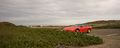
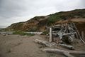
Anyway, at 8:45 the package had been sent and JBQ was on his way. Traffic through San Francisco and all the way to San Rafael was light. After a quick pause in San Rafael to check the route (and to discover that the Droid had almost no battery left), it was time to drive the slower part of the route, i.e. mile after mile of 30, 35 and 40 mph speed limits. An boat stranded ashore in Inverness was begging to be photographed. Driving through the NPS-managed land, the landscape looked very dramatic, especially with rays of sunlight peeking through a highly textured cloud cover. Eventually, the Point Reyes Beach South parking lot was reached a bit before 11am, and the cars there could be counted on the fingers of a single hand.
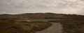
With his camera bag strapped on one shoulder, his tripod bag on the other, and a Nexus One in a pocket, it was time to walk on the beach toward the exact coordinates, less than half a mile away. An ominous sign on the parking lot reminded beachgoers that the Pacific Ocean is actually dangerous. It's unclear whether a shark bite would qualify for a raptor achievement, though. JBQ had never actually been on that specific beach, even though he had seen it a few times from the Point Reyes lighthouse area, and it is as huge in person as it seems from above. On a menacingly overcast Saturday morning in January, it was also pretty much deserted.
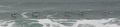
There were some signs of human presence on the beach, with numerous footsteps but also some trash. Picking up a bit would be good for a token geotrash achievement, though there was potential for a lot more cleanup. There were also quite some birds, pelicans flying just above the waves, and some unknown birds digging in the sand and flying away as soon as someone approached. With the right equipment, this'd have been a great opportunity for some bird photography. There were some big waves that brought out the beautiful blue-green color of the ocean.
Getting close to the spot, there was a primitive shelter. It doesn't look like someone went for a camping achievement, as there was no sign of recent activity. Finally, climbing to the top of a tiny dune, the exact coordinates were reached. A quick tripod setup and a makeshift xkcd sign later, the canonical picture was taken. Just below the spot, the usual sand-growing rubbery plants were unusually colorful, which led to yet another picture being taken, which could actually make a nice desktop background.
On the way back toward the car, a quick encounter with "Richard" showed how geotrashing is done (with a good bag), and led to a discussion about birds and bird photography. With two of their friends already in the water, a pair of surfers were looking toward the ocean, uncertain whether to go in and face the big waves. Back at the parking lot, the little garbage that got picked on the beach ended up in a garbage container, and a last look at the ocean showed even more waves.
Driving back, the boat in Inverness was still begging to be photographed, but this time it got its wish. Along highway 1, the Camaro was screaming "play with me" and it got to stretch its legs and play in the curves and in the hills; other drivers must have feared the red monster rushing at them with headlights on, as they seemed very eager to use the turnouts. Finally, the entire one-person crew was back home at 2pm.
Photos
100% of cars on the south parking lot are geohashers
Grand total of 5 cars on the parking lot
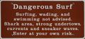
"Sharks? They have sharks? Can I have one?"

Deserted beach looking north
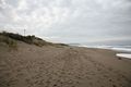
Deserted beach looking south
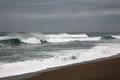
Some pretty serious waves
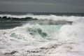
Yup, I'm gonna stay on dry land
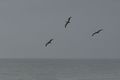
Pelicans cruising high above the waves
Pelicans inches above the water
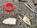
Assorted trash in its natural habitat
Did someone try for a camping achievement?

Right at the spot, with a bit of cell coverage in the middle of nowhere
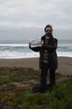
I was there, I swear. Does the sweater qualify for a circus achievement?

This stuff grows everywhere on the dunes, but is rarely that colorful
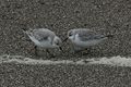
Those little guys were digging for food in the sand...
... and they didn't let anyone get close
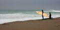
"Do you really think we should go? This looks cold!"
Trash about to go in the dumpster
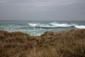
The waves look big even from the parking lot
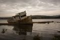
This boat is like a top model posing for photographers


Achievements
JBQ earned the Land geohash achievement
|
JBQ earned the GeoTrash Geohash Achievement
|