Difference between revisions of "2010-02-01 -38 175"
imported>Greenslime (→Photos) |
imported>FippeBot m (Location) |
||
| (3 intermediate revisions by 2 users not shown) | |||
| Line 14: | Line 14: | ||
__NOTOC__ | __NOTOC__ | ||
== Location == | == Location == | ||
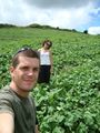
| − | Arataki, South Waikato, New Zealand | + | A field planted in unidentifiable plants near Arataki, South Waikato, New Zealand |
== Participants == | == Participants == | ||
* [[user:Greenslime|Greenslime]] | * [[user:Greenslime|Greenslime]] | ||
| − | * JimmyNZ | + | * [[User:JimmyNZ|JimmyNZ]] |
== Plans == | == Plans == | ||
| Line 37: | Line 37: | ||
<gallery> | <gallery> | ||
| − | File:2010_02_01_-38_175_scrawls_from_the_internet_cafe.jpg | + | File:2010_02_01_-38_175_scrawls_from_the_internet_cafe.jpg | Scrawls from the internet cafe |
| − | File:2010_02_01_-38_175_poihipi_rd.jpg | + | File:2010_02_01_-38_175_poihipi_rd.jpg | Poihipi Rd sign |
| − | File:2010_02_01_-38_175_kaahu_rd.jpg | + | File:2010_02_01_-38_175_kaahu_rd.jpg | Kaahu Rd sign |
| − | File:2010_02_01_-38_175_here_be_hash.jpg | + | File:2010_02_01_-38_175_here_be_hash.jpg | here be hash |
| − | File:2010_02_01_-38_175_hash_be_here.jpg | + | File:2010_02_01_-38_175_hash_be_here.jpg | hash be here |
| − | File:2010_02_01_-38_175_view_from_the_hash.jpg | + | File:2010_02_01_-38_175_view_from_the_hash.jpg | View from the hash showing planting of unidentified plants |
| − | File:2010_02_01_-38_175_GPS_evidence.jpg | + | File:2010_02_01_-38_175_GPS_evidence.jpg | GPS evidence |
</gallery> | </gallery> | ||
[[Category:Coordinates reached]][[Category:Expeditions with photos]][[Category:Expeditions]] | [[Category:Coordinates reached]][[Category:Expeditions with photos]][[Category:Expeditions]] | ||
| + | {{location|NZ|WKO}} | ||
Latest revision as of 00:41, 9 August 2019
| Mon 1 Feb 2010 in -38,175: -38.4945115, 175.8367276 geohashing.info google osm bing/os kml crox |
Location
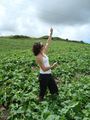
A field planted in unidentifiable plants near Arataki, South Waikato, New Zealand
Participants
Plans
On way back from tramping in Kaimanawas, nipped into internet cafe to check out the hashes on route. Accessible hash was discovered just off the route home - about 100 m off a road, off a road, off SH 32. After brekkie, will invade a farmers paddock and continue home.
Expedition
Okay, so we are a little hooked on this geohashing thing. This one involved us actually paying to use internet to find out where today's hash was. Seeings we were traveling anyway, heading back to our home town Auckland, we could fit in a detour or two somewhere (still thinking multihash potential) and besides, our GPS still had battery left, may as well use it before JimmyNZ had to return it (listen to the addict justifying the behaviour....)
Anyway, this one should be easy! And it was surprisingly close the the hash achieved two days prior. Google maps showed it to be in a farmers paddock (although previous experience shows that sometimes Google can lie) and there were some buildings close to the site. The journey to the site was swift and uneventful. The paddock was planted in some unidentifiable plant probably used for animal feed. We visited the three houses in the immediate area, two were unoccupied (obviously the occupants were actually working on a Monday, unlike us). The third house had a large farmer and a large farmers large wife in attendance. JimmyNZ explained the game, and the reply came as 'If my house gets burgled, I'll hunt you down and f$%kn kill ya.' I imagine it was in that not-so-serious, but deadly-serious tone that people use sometimes. No doubt he had a gun. We are unsure if he got our license plate number.
Permission granted, we vaulted the fence, went to the hash about 100m in, trying not to stomp plants, got the photos, and gapped it out of there. I'm sure I saw the farmer on this deck with his gun......
Tracklog
From Taupo, SH1 onto Poihipi Rd, onto Kaahu Rd.
Photos
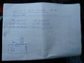
Scrawls from the internet cafe
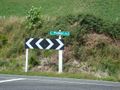
Poihipi Rd sign
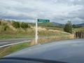
Kaahu Rd sign
here be hash
hash be here
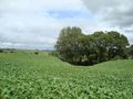
View from the hash showing planting of unidentified plants
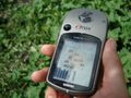
GPS evidence


