2010-02-21 48 11
| Sun 21 Feb 2010 in 48,11: 48.1965597, 11.1560514 geohashing.info google osm bing/os kml crox |
Location
W of München, S of Mammendorf, close to the village of Egg. Easily accessible (train, then walk).
Participants
Plans
Time to 1-up the score for München's graticule!
Y'all, I might be interested in checking out this Sunday's location in München's West, almost revisiting 2009-04-24 48 11 and 2009-04-03 48 11. S-Bahn or RB from München (or RB from Augsburg and beyond) to Mammendorf, then walk. Not sure about the time yet, no other plans for the day (Sundays are awesome!). I could adjust to others' plans, if anyone else wants to go. --Zb 11:45, 20 February 2010 (UTC)--Zb 11:37, 20 February 2010 (UTC)
Tryin' to make it for sunrise. --Zb 03:23, 21 February 2010 (UTC)
Narrative
Zb left the house at 5 am by bike for München's main station, went by train to Mammendorf, arrived at the geohash at 7:09 just before sunrise, stayed for a bit and then went trainspotting during a long walk via Mammendorf and Haspelmoor to Althegnenberg, from where he took the train back to München, arriving home at 12:15 pm. It was beautiful.
Photos
Plenty to come...
Early Trains to Mammendorf.
5:30 am, München Hbf.
The play on words that comes to mind when pronouncing its name in English really is appropriate because of the very narrow layout of the seats.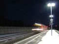
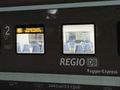
6:21 am, Mering.
Changing onto another Class 440 a.k.a. Fugger-Express.


At the Coordinates
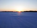
Sunrise between Mammendorf and Egg, at the coordiantes.

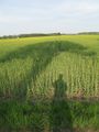
Revisiting 2009-04-03 48 11 (cf. Revisited).
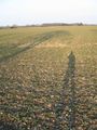
Geohash on 2009-04-03. The spot is where the shadows would meet, if they were longer.
Same Time, same place. Spring has hit the auto color enhancement button.
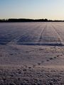
No shadows this time, because the sun will take some more hours till I would have it in my back.


