Difference between revisions of "2010-02-22 49 8"
imported>Koepfel (+report) |
imported>FippeBot m (Location) |
||
| (One intermediate revision by one other user not shown) | |||
| Line 27: | Line 27: | ||
I checked the train schedules and noticed a S4 back to Karlsruhe was leaving at 14:16, so I rushed back to the station and arrived back at Durlacher Tor by 14:49. | I checked the train schedules and noticed a S4 back to Karlsruhe was leaving at 14:16, so I rushed back to the station and arrived back at Durlacher Tor by 14:49. | ||
| − | |||
<gallery> | <gallery> | ||
| − | + | File:2010-02-22 49 8-S4.jpg|arriving in Bretten | |
| + | File:2010-02-22 49 8-stop.jpg|light rail stop Bretten Stadtmitte | ||
| + | File:2010-02-22 49 8-S9.jpg|walking towards the hashpoint | ||
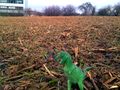
| + | File:2010-02-22 49 8-field.jpg|Hash Field in sight | ||
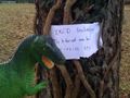
| + | File:2010-02-22 49 8-hashscot.jpg|Reached | ||
| + | File:2010-02-22 49 8-marker.jpg| | ||
| + | File:2010-02-22 49 8-tree.jpg|Hash Tree | ||
| + | File:2010-02-22 49 8-mud.jpg|Mud | ||
</gallery> | </gallery> | ||
[http://geohash.koepfel.de/2010-02-22_49_8/index.html more pictures] | [http://geohash.koepfel.de/2010-02-22_49_8/index.html more pictures] | ||
| − | + | ||
[[category:Expeditions]] | [[category:Expeditions]] | ||
[[Category:Coordinates reached]] | [[Category:Coordinates reached]] | ||
[[Category:Expeditions with photos]] | [[Category:Expeditions with photos]] | ||
[[Category:Expeditions with videos]] | [[Category:Expeditions with videos]] | ||
| + | {{location|DE|BW|KA}} | ||
Latest revision as of 00:58, 9 August 2019
| Mon 22 Feb 2010 in 49,8: 49.0312415, 8.6994369 geohashing.info google osm bing/os kml crox |
Location
In a field in Bretten
Participants
Plans
The outdated satellite image shows a field, Bretten's official city map doesn't show any building either, but still the possibility of a new building being there couldn't be ruled out. Koepfel will still try to reach it, probably arriving in Bretten at 14:00. One can get there easily by using the S4 from Karlsruhe to Bretten Stadtmitte.
Expedition Report
Koepfel
This was a short expedition. After spending the morning at the university, I entered the S4 to Bretten, leaving Durlacher Tor at 13:08. 33 minutes later, it arrived at Bretten Stadtmitte (town center). From there, it was a short walk towards the hashpoint. From the stop Stadtmitte, I walked past the stop Bretten Rechberg, served by the S9 to Mühlacker, walked for a few more meters and arrived at the hash field. To my relief, nothing was built on it, contrary to the field next to it, which is now the location af a car dealership.
I found the actual spot in no time, by 14:00, stuck a marker to a nearby tree, took a few photos and a video. As usual, the field was muddy, my shoes got heavier with each step. Luckily, I was wearing my old pair of shoes, that were still covered in mud from my previous expedition, which I haven't used sinc3. As I have a second pair of shoes for daily life, I'll probably make these my dedicated geohashing shoes.
I checked the train schedules and noticed a S4 back to Karlsruhe was leaving at 14:16, so I rushed back to the station and arrived back at Durlacher Tor by 14:49.
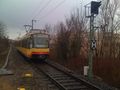
arriving in Bretten
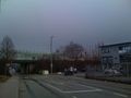
light rail stop Bretten Stadtmitte
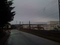
walking towards the hashpoint
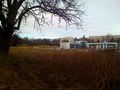
Hash Field in sight
Reached
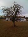
Hash Tree
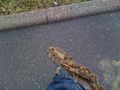
Mud


