2010-03-08 45 -122
| Mon 8 Mar 2010 in 45,-122: 45.6566006, -122.5252034 geohashing.info google osm bing/os kml crox |
Location
Up on the Washington side of the river, to the east. Seems to be fairly close to a road, and in an open space, may require permission.
Participants
- Aperfectring will leave work at or before 5, head home really quick, then start on the trek to the hashpoint, likely a bit over an hour, so I should make it sometime around 6:30.
- Rhonda is on a plane to the area, and seemed rather interested in attending
- Jim is game to visit the city of Vancouver and see another geohasher. He needs to feed his car, though. Also, I expect it will take us much more than an hour due to rush hour traffic! Is Rhonda going to meet us, or are we supposed to get her at the airport on the way!
Plans
According to Clark County's tax maps, the property is owned by the City of Vancouver! [1] Unfortunately that link won't take you to the specific property, but if you search for account number 162509000 on the "Find Parcel" link, it will take you there. - APR (?_
It kinda looks like a park on Google Maps - Jim
I was guessing a school, because the outbuildings looked like portables. -Rhonda
Expedition
After some initial planning during the day, and brief conversations with Jim, Rhonda, and aperfectring , in which none of them talked at the same time, aperfectring left work a little early. We decided that taking one car to the hashpoint seemed to be the best way to go, and since neither Jim nor aperfectring wanted to find parking in the city, where Rhonda's hotel was, that meant aperfectring was the best candidate for driving.
After some relatively brief wrestling with traffic to get down into the city, aperfectring successfully maneuvered his way to Rhonda's hotel, and Jim walked up to make sure she found the car. They all then drove a very circuitous route towards the hashpoint, very happy that aperfectring's GPS nav unit was dictating directions, because they would have gotten hopelessly lost otherwise. They eventually made it to the school where the hashpoint lay, and it looked slightly discouragingly fenced in. As they pulled into the parking spot, though, they noticed that it was trivial to get into the fenced area, there wasn't even a gate. As they were walking over to the trees which the hashpoint lay under, they happily noticed a complete lack of the expected underbrush which usually accompanies trees in the area. Approaching further, they noticed some picnic tables under the cover of said trees. As they got even closer, they began to realize that the hashpoint looked to be almost directly below a light on a pole.
Pictures were taken, comments were made about the unexpected easiness of the expedition, and they headed back to the car. There they discussed dinner, and decided to visit the Thai Orchard in Vancouver (Washington). Once in the restaurant, they took a very long time talking about this and that, and not really deciding upon what to eat. Eventually they made a couple of choices, and asked for suggestions from the waitress for a third. Delicious food was eaten, and then one more wrong turn, and dropping off of Rhonda, then Jim.
Tracklog
Photos
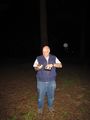
Jim at the hashpoint
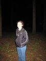
Rhonda at the hashpoint
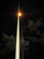
Light pole at the hashpoint
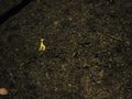
Hashscot and xkcd marker
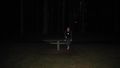
Picnic tables
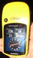
Proof


