Difference between revisions of "2010-04-13 45 -122"
From Geohashing
imported>Jiml (Adding Photos) |
imported>Jiml (Add Ribbon) |
||
| Line 44: | Line 44: | ||
| + | {{land_geohash | ||
| + | | latitude = 45 | ||
| + | | longitude = -122 | ||
| + | | date = 2010-04-13 | ||
| + | | name = [[User:aperfectring|APR]] and [[User:Jiml|Jim]] | ||
| + | }} | ||
[[Category:Expeditions]] | [[Category:Expeditions]] | ||
Revision as of 07:19, 13 July 2010
| Tue 13 Apr 2010 in 45,-122: 45.5007359, -122.9087812 geohashing.info google osm bing/os kml crox |
Location
The 22500 block of SW Johnson, close to Century High School. It appears to be in the street.
Participants
- Jim - Was picked up by Aperfectring on the way.
- Aperfectring - Picked up Jim on the way.
Plans
Program a GPS, go, and take pictures.
Expedition
- Approaching hashpoint on foot. -- aperfectring @45.5007,-122.9083 20:40, 13 April 2010 (UTC)
- Expedition success. Speed racer achieved. -- aperfectring @45.5006,-122.9073 20:40, 13 April 2010 (UTC)
Photos
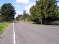
Scenery around the hashpoint

Picture of the hashpoint :-)
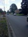
Traffic @ the hash preventing good gps picture @45.5003,-122.9073
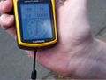
Proof of the hashpoint

Jiml dodging traffic @ the hashpoint. @45.4968,-122.8867
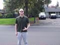
APR at the hashpoint


APR and Jim earned the Land geohash achievement
|