Difference between revisions of "2010-04-25 45 -123"
imported>Aperfectring (→Participants) |
imported>FippeBot m (Location) |
||
| (11 intermediate revisions by 2 users not shown) | |||
| Line 1: | Line 1: | ||
| − | |||
<!-- If you did not specify these parameters in the template, please substitute appropriate things for IMAGE, LAT, LON, and DATE (YYYY-MM-DD format) | <!-- If you did not specify these parameters in the template, please substitute appropriate things for IMAGE, LAT, LON, and DATE (YYYY-MM-DD format) | ||
| Line 12: | Line 11: | ||
}} | }} | ||
| − | + | ||
| − | |||
== Location == | == Location == | ||
| − | |||
In Camp Wilkerson Park, NE of Pittsburg, Oregon | In Camp Wilkerson Park, NE of Pittsburg, Oregon | ||
== Participants == | == Participants == | ||
| − | + | *[[User:Aperfectring|APR]] | |
| − | *[[User:Aperfectring|APR]] | + | *[[User:Jiml|Jim]] |
== Plans == | == Plans == | ||
| − | + | Jim is hoping to head north and visit this hashpoint on the way. | |
== Expedition == | == Expedition == | ||
<!-- how it all turned out. your narrative goes here. --> | <!-- how it all turned out. your narrative goes here. --> | ||
| − | == | + | === [[User:Aperfectring|Aperfectring's]] Visit === |
| − | + | ||
| + | ==== Live reports ==== | ||
| + | *Off to get gas, cash for the honor box, and then to the point! -- [[User:Aperfectring|aperfectring]] [http://www.openstreetmap.org/?lat=45.52182785&lon=-122.97181426666667&zoom=16&layers=B000FTF @45.5218,-122.9718] 13:57, 25 April 2010 (UTC) | ||
| + | |||
| + | *Got gas, but no atm, will get cash on the way. -- [[User:Aperfectring|aperfectring]] [http://www.openstreetmap.org/?lat=45.52963811666667&lon=-122.95577371666667&zoom=16&layers=B000FTF @45.5296,-122.9558] 14:04, 25 April 2010 (UTC) | ||
| + | |||
| + | *Got gas, but no atm, will get cash on the way. -- [[User:Aperfectring|aperfectring]] [http://www.openstreetmap.org/?lat=45.52963811666667&lon=-122.95577371666667&zoom=16&layers=B000FTF @45.5296,-122.9558] 14:04, 25 April 2010 (UTC) | ||
| + | |||
| + | *Coordinates reached, no cell signal @ the point, bad GPS signal as well. Proof is tenuous, but I am certain I made it. -- [[User:Aperfectring|aperfectring]] [http://www.openstreetmap.org/?lat=45.528662&lon=-122.866035&zoom=16&layers=B000FTF @45.5287,-122.8660] 16:39, 25 April 2010 (UTC) | ||
| + | |||
| + | ==== Post-expedition Report ==== | ||
| + | I started off this morning being woken up by one of my smoke detectors having a low battery, so starting to beep at me at about 6 AM. This rather annoyed me, so to prevent it from happening again, I went down to the garage, got my foldable table, a battery, and went back up to my bedroom to change the battery. As soon as that was done, I decided that rather than going back to sleep, I would go out and geohash this morning. I then proceeded to grab my gear, and head out the door by about 7AM. | ||
| + | |||
| + | I stopped to get gas and cash for the honor box that was supposed to be there, but the gas station had no ATM. I decided that I would just drive there, and find a place to stop on the way. I stopped at a credit union in Vernonia, Oregon and got cash. I then stopped at a convenience store, got a drink (to get change), and proceeded driving the mountain roads off towards the hashpoint. | ||
| + | |||
| + | The hashpoint itself was about 20ft off of a gravel road, but I couldn't get an accurate GPS fix. On the road I was getting anywhere between 15 and 90 ft to the hashpoint. I trudged into the woods a bit where it looked like the point was, and called it reached. I would most definitely get to the actual point, but technology prevented it. Proof pictures were taken, and the [[PBGH games]] concept officially ended its planning stage! | ||
| + | |||
| + | I then drove myself back along a different route, stopping for a decent breakfast and at a store to buy a new CD along the way. All in all a great trip! | ||
| + | |||
| + | === [[User:Jiml|Jim]]'s Expedition === | ||
| + | Jim first made another attempt at the hashpoint from March 28, and didn't succeed any better. The hashpoint | ||
| + | didn't seem to be on a road anymore, perhaps due to logging. | ||
| + | |||
| + | Then he proceeded to today's hashpoint, and found it, though the signal was just about as odd as for APR. | ||
| + | |||
== Photos == | == Photos == | ||
| − | + | === APR Photos=== | |
| − | |||
| − | |||
<gallery perrow="4"> | <gallery perrow="4"> | ||
| + | Image:2010-04-25 45 -123 apr01.JPG|Hooray ATM! | ||
| + | Image:2010-04-25 45 -123 apr03.JPG|Proof | ||
| + | Image:2010-04-25 45 -123 apr04.JPG|Avast relet, defend yourself! | ||
| + | Image:2010-04-25 45 -123 apr05.JPG|It's Me! | ||
| + | Image:2010-04-25 45 -123 apr06.JPG|Look one way | ||
| + | Image:2010-04-25 45 -123 apr08.JPG|Then another | ||
| + | Image:2010-04-25 45 -123 apr09.JPG|Finally up! | ||
</gallery> | </gallery> | ||
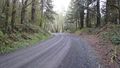
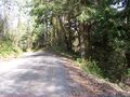
| + | === Jim's Mar 28 Retro Hash === | ||
| + | <gallery perrow="4"> | ||
| + | Image:2010-03-28_45_-123-try2-gate.jpg | Gate to the hashpoint | ||
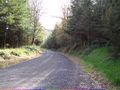
| + | Image:2010-03-28_45_-123-try2-road.jpg | The road up | ||
| + | Image:2010-03-28_45_-123-try2-road2.jpg.jpg |The road up | ||
| + | Image:2010-03-28_45_-123-try2-road3.jpg | The road up | ||
| + | Image:2010-03-28_45_-123-try2-slash.jpg | The way down | ||
| + | Image:2010-03-28_45_-123-try2-view.jpg | View from near the hashpoint | ||
| + | Image:2010-03-28_45_-123-try2-view2.jpg | View from near the hashpoint | ||
| + | Image:2010-03-28_45_-123-try2-view3.jpg | View from near the hashpoint | ||
| + | </gallery> | ||
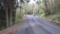
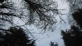
| − | + | === Jim's Today's hashpoint photos=== | |
| − | + | <gallery perrow="4"> | |
| − | + | Image:2010-04-25_45_-123-road1.jpg | Jim looks one way | |
| + | Image:2010-04-25_45_-123-road2.jpg | Then another | ||
| + | Image:2010-04-25_45_-123-hashpt.jpg | View of the hashpoint | ||
| + | Image:2010-04-25_45_-123-proof.jpg | GPS Proof | ||
| + | Image:2010-04-25_45_-123-grin.jpg | A geohasher at the point | ||
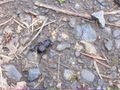
| + | Image:2010-04-25_45_-123-bug.jpg | A nearby bug | ||
| + | </gallery> | ||
| − | |||
| − | |||
| − | |||
| − | |||
| − | |||
[[Category:Expeditions]] | [[Category:Expeditions]] | ||
| − | |||
[[Category:Expeditions with photos]] | [[Category:Expeditions with photos]] | ||
| − | |||
| − | |||
| − | |||
| − | |||
| − | |||
[[Category:Coordinates reached]] | [[Category:Coordinates reached]] | ||
| − | + | {{location|US|OR|CL}} | |
| − | |||
| − | |||
| − | |||
| − | |||
| − | |||
| − | |||
| − | |||
| − | |||
| − | |||
Latest revision as of 01:46, 9 August 2019
| Sun 25 Apr 2010 in 45,-123: 45.9440030, -123.0453958 geohashing.info google osm bing/os kml crox |
Contents
Location
In Camp Wilkerson Park, NE of Pittsburg, Oregon
Participants
Plans
Jim is hoping to head north and visit this hashpoint on the way.
Expedition
Aperfectring's Visit
Live reports
- Off to get gas, cash for the honor box, and then to the point! -- aperfectring @45.5218,-122.9718 13:57, 25 April 2010 (UTC)
- Got gas, but no atm, will get cash on the way. -- aperfectring @45.5296,-122.9558 14:04, 25 April 2010 (UTC)
- Got gas, but no atm, will get cash on the way. -- aperfectring @45.5296,-122.9558 14:04, 25 April 2010 (UTC)
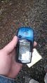
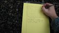
- Coordinates reached, no cell signal @ the point, bad GPS signal as well. Proof is tenuous, but I am certain I made it. -- aperfectring @45.5287,-122.8660 16:39, 25 April 2010 (UTC)
Post-expedition Report
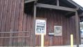
I started off this morning being woken up by one of my smoke detectors having a low battery, so starting to beep at me at about 6 AM. This rather annoyed me, so to prevent it from happening again, I went down to the garage, got my foldable table, a battery, and went back up to my bedroom to change the battery. As soon as that was done, I decided that rather than going back to sleep, I would go out and geohash this morning. I then proceeded to grab my gear, and head out the door by about 7AM.
I stopped to get gas and cash for the honor box that was supposed to be there, but the gas station had no ATM. I decided that I would just drive there, and find a place to stop on the way. I stopped at a credit union in Vernonia, Oregon and got cash. I then stopped at a convenience store, got a drink (to get change), and proceeded driving the mountain roads off towards the hashpoint.
The hashpoint itself was about 20ft off of a gravel road, but I couldn't get an accurate GPS fix. On the road I was getting anywhere between 15 and 90 ft to the hashpoint. I trudged into the woods a bit where it looked like the point was, and called it reached. I would most definitely get to the actual point, but technology prevented it. Proof pictures were taken, and the PBGH games concept officially ended its planning stage!
I then drove myself back along a different route, stopping for a decent breakfast and at a store to buy a new CD along the way. All in all a great trip!
Jim's Expedition
Jim first made another attempt at the hashpoint from March 28, and didn't succeed any better. The hashpoint didn't seem to be on a road anymore, perhaps due to logging.
Then he proceeded to today's hashpoint, and found it, though the signal was just about as odd as for APR.
Photos
APR Photos
Hooray ATM!
Proof
Avast relet, defend yourself!
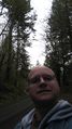
It's Me!
Look one way
Then another
Finally up!


Jim's Mar 28 Retro Hash
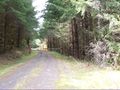
Gate to the hashpoint
The road up
The road up
The road up
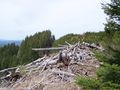
The way down
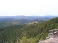
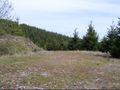
View from near the hashpoint
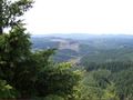
View from near the hashpoint
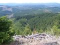
View from near the hashpoint


Jim's Today's hashpoint photos
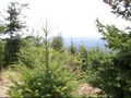
Jim looks one way
Then another
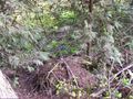
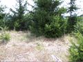
View of the hashpoint
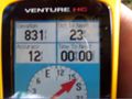
GPS Proof
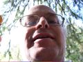
A geohasher at the point
A nearby bug


