Difference between revisions of "2010-05-01 53 -113"
imported>FippeBot m (Location) |
m (More specific location) |
||
| Line 25: | Line 25: | ||
[[Category:Expeditions]] | [[Category:Expeditions]] | ||
[[Category:Coordinates reached]] | [[Category:Coordinates reached]] | ||
| − | {{location|CA|AB}} | + | {{location|CA|AB|LD}} |
Latest revision as of 23:20, 9 August 2020
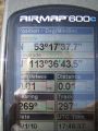
| Sat 1 May 2010 in 53,-113: 53.2938299, -113.6122118 geohashing.info google osm bing/os kml crox |
Location
The point is near Edmonton International Airport, beside a driveway off the Range Road immediately west of the airport restricted area. Reconnaissance for a previous geohash on the same road and Google satellite images suggest that the location is accessible on unfenced cropland, expected to be unplanted stubble at this time of year.
Participants
- Robyn hopes to be here around 12:00-1:00 p.m.
Expedition
Yes, I made it. Both the point and the flight. Details and proof later.
Slightly over a year later
I just found this unfinished report. I still remember it fairly well. It was right across the rural behind-the-airport street from a no-trespassing hash the previous year. I drove right past that site, pulled into a long farm driveway on the other side of the road and stepped a few metres into an unplanted, unfenced field for the point.
Here ...

... was me.


Then I returned the rental car and checked in for my flight.