Difference between revisions of "2010-05-09 49 -123"
imported>Rhonda (→Location) |
m (More specific location) |
||
| (19 intermediate revisions by 6 users not shown) | |||
| Line 1: | Line 1: | ||
| − | |||
| − | |||
| − | |||
| − | |||
| − | |||
| − | |||
{{meetup graticule | {{meetup graticule | ||
| lat=49 | | lat=49 | ||
| Line 12: | Line 6: | ||
}} | }} | ||
| − | + | ||
__NOTOC__ | __NOTOC__ | ||
== Location == | == Location == | ||
| − | West Vancouver, and road accessible. Just inside a building, which is next to one that | + | West Vancouver, and road accessible. Just on the inside edge of a building, which is next to one that Google says hosts a Royal Canadian Air Cadets squadron. |
== Participants == | == Participants == | ||
| − | + | *[[User:Rhonda|Rhonda]] | |
| + | *[[User:Xore|Xore]] | ||
| + | *[[User:thepiguy|thepiguy]] | ||
| + | *[[User:Arbron|Arbron]] - By himself | ||
| + | *[[User:Robyn|Robyn]] - Retrohash | ||
| + | *[[User:Wade|Wade]] - Retrohash | ||
== Plans == | == Plans == | ||
| − | + | No plans, just went! - Arbron | |
| + | |||
| + | .. in three separate, uncoordinating parties. | ||
== Expedition == | == Expedition == | ||
| − | |||
| − | == | + | ===Rhonda, Xore & thepiguy=== |
| − | < | + | thepiguy headed out early in the morning and managed to end up smack-dab in the middle of Vancouver's largest foot race: the Vancouver Sun Run. About 50,000 people were lined up down one of Vancouver's busiest streets, meaning thepiguy's bus <i>probably</i> wasn't going to be coming by any time soon.He opted to catch the Sea Bus instead (a small ferry) and managed to get some beautiful shots Vancouver. |
| + | |||
| + | Once at the Geohash, he found Rhonda and Xore wondering around in a school parking lot. Apparently the GPS satellites had called in sick because of the nice weather, so they instead used their memory of Google and a bit of creativity to locate the exact point. | ||
| + | |||
| + | ===Arbron=== | ||
| + | |||
| + | ===Robyn & Wade=== | ||
| + | We were in Oregon the morning of the geohash, but planned to drive back to Vancouver that night, so decided to go to the geohash before actually going home. Maybe we could log another [[2008-09-19_49_-122|midnight geohash]]. | ||
| + | |||
| + | We drove up the I-5 with a new chair in the back, and then stopped at the duty-free, succeeding (not like [[2010-03-28_global#Another_Border_Crossing|last time]]) in finding a duty free store that was en route, open, and on the correct side of the border. Lots of people managed to find it, and also managed to choose what they wanted to buy and find their way to the cash register line up before we did. And for reasons we couldn't quite discern, the line up moved very slowly. | ||
| + | |||
| + | We finally got our booze and advanced to the border crossing itself. The customs officer seemed incredulous that we had driven seven hours each way to visit friends in Oregon. He quizzed us about how we knew them and how long we had known them, and eyed us suspiciously. I'm ''really'' glad we didn't get this guy on the way back from a geohash in Idaho. | ||
| + | |||
| + | After we were allowed into Canada, the GPS indicated that we would not reach the geohash until 12:18. But it also thought we should go all the way downtown then over the Lions Gate Bridge. Robyn was determined to do better, and directed Wade through New Westminster to the trans-Canada, and down Taylor Way instead of up it. Left, left, left, park and run headlong into the darkness where there was supposed to be a parking lot. We counted down to zero on two GPSes and snapped the defining photo to prove we were there--twelve minutes into the following day. Geohash: '''thwarted'''. Retrohash '''achieved!''' | ||
| + | |||
| + | The previous people at the geohash had marked their achievement at a slightly different place than we determined as ground zero. We wondered whether the satellite error had changed over the day, or if they took some liberties with the location to get their mark on the painted crosshairs. | ||
| + | |||
| + | On the way home we passed a police roadblock and were really glad they didn't stop us. Can you imagine? | ||
| + | |||
| + | "Where are you coming from?" | ||
| + | "Oregon." | ||
| + | "Why are you going ''south''?" | ||
| + | |||
| + | I had a good answer prepared, though. "We stopped off on the North Shore to meet some friends. We didn't get to see them though. We were too late." | ||
| + | |||
| + | That had better be a ''really'' good bottle of duty free Bailey's. Perhaps we'll save it for a couch potato geohash. | ||
| + | |||
| + | ''Correction: My camera clock is five minutes fast. We were only seven minutes late.'' | ||
== Photos == | == Photos == | ||
| − | <!-- | + | ===Rhonda, Xore & thepiguy=== |
| − | Image: | + | <gallery> |
| − | -- | + | Image:2010-05-09_49_-123_oops.JPG|Vancouver Sun Run, 15 minutes to start. |
| − | + | Image:2010-05-09_49_-123_lions.JPG|The Lions Gate Bridge. | |
| + | Image:2010-05-09_49_-123_vancouver.JPG|Vancouver! | ||
| + | Image:2010-05-09_49_-123_gps.JPG| Wildly inaccurate GPS shot. | ||
| + | Image:2010-05-09_49_-123_calendar.JPG|thepiguy hand-delivers the final calendar! | ||
| + | Image:2010-05-09_49_-123_mark.JPG|That ought to make some school teachers a little nervous! | ||
| + | Image:2010-05-09_49_-123_hashers.JPG|Happy hashers. | ||
| + | Image:2010-05-09_49_-123_hashscots.JPG|Hahscotch? | ||
| + | Image:2010-05-09_49_-123_scotch.JPG|Xore decides to take a turn. | ||
| + | Image:2010-05-09_49_-123_square.JPG|"Wait. I remember this game being bigger. Was I really that small?!?" | ||
</gallery> | </gallery> | ||
| + | ===Arbron=== | ||
| + | <gallery> | ||
| + | Image:P1030094.jpg | Arbron's hand at the hash. | ||
| + | Image:P1030096.jpg | Arbron at the hash. | ||
| + | Image:2010-05-09 49 -123 Makings of Others.jpg | Signs left by others. | ||
| + | </gallery> | ||
| − | + | ===Wade & Robyn === | |
| − | + | And then even later, twelve minutes into the next day, along came Wade and Robyn. I'm categorizing these in the Meetup on 2010-05-09 category because the expedition was launched and attempted on the correct day. | |
| − | |||
| − | < | + | <gallery perrow=3> |
| − | + | Image:2010-05-09 49 -123.night.jpg|We raced through the night ... | |
| − | + | Image:2010-05-09 49 -123.midnight.jpg|but the seconds ticked down to midnight about 400 metres from the geohash ... | |
| − | --> | + | Image:2010-05-09 49 -123.gps.jpg|... so we got there slightly late. |
| + | Image:2010-05-09 49 -123.Robyngrin.jpg|Robyn was nevertheless pleased to reach the geohash. | ||
| + | Image:2010-05-09 49 -123.Wadegrin.jpg|Wade's maniacal laughter is actually at Robyn for having the camera stuck in self-timer mode. | ||
| + | Image:2010-05-09 49 -123.baileys.jpg|That had '''better''' be a really good bottle of Bailey's. | ||
| + | </gallery> | ||
| − | |||
[[Category:Expeditions]] | [[Category:Expeditions]] | ||
| − | |||
[[Category:Expeditions with photos]] | [[Category:Expeditions with photos]] | ||
| − | |||
| − | |||
| − | |||
| − | |||
| − | |||
[[Category:Coordinates reached]] | [[Category:Coordinates reached]] | ||
| − | + | [[Category:Retro coordinates reached]] | |
| − | + | {{location|CA|BC|MV}} | |
| − | |||
| − | |||
| − | |||
| − | |||
| − | |||
| − | |||
| − | [[Category: | ||
| − | |||
Latest revision as of 23:21, 9 August 2020
| Sun 9 May 2010 in 49,-123: 49.3330888, -123.1312620 geohashing.info google osm bing/os kml crox |
Location
West Vancouver, and road accessible. Just on the inside edge of a building, which is next to one that Google says hosts a Royal Canadian Air Cadets squadron.
Participants
Plans
No plans, just went! - Arbron
.. in three separate, uncoordinating parties.
Expedition
Rhonda, Xore & thepiguy
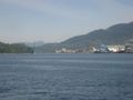
thepiguy headed out early in the morning and managed to end up smack-dab in the middle of Vancouver's largest foot race: the Vancouver Sun Run. About 50,000 people were lined up down one of Vancouver's busiest streets, meaning thepiguy's bus probably wasn't going to be coming by any time soon.He opted to catch the Sea Bus instead (a small ferry) and managed to get some beautiful shots Vancouver.
Once at the Geohash, he found Rhonda and Xore wondering around in a school parking lot. Apparently the GPS satellites had called in sick because of the nice weather, so they instead used their memory of Google and a bit of creativity to locate the exact point.
Arbron
Robyn & Wade
We were in Oregon the morning of the geohash, but planned to drive back to Vancouver that night, so decided to go to the geohash before actually going home. Maybe we could log another midnight geohash.
We drove up the I-5 with a new chair in the back, and then stopped at the duty-free, succeeding (not like last time) in finding a duty free store that was en route, open, and on the correct side of the border. Lots of people managed to find it, and also managed to choose what they wanted to buy and find their way to the cash register line up before we did. And for reasons we couldn't quite discern, the line up moved very slowly.
We finally got our booze and advanced to the border crossing itself. The customs officer seemed incredulous that we had driven seven hours each way to visit friends in Oregon. He quizzed us about how we knew them and how long we had known them, and eyed us suspiciously. I'm really glad we didn't get this guy on the way back from a geohash in Idaho.
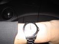
After we were allowed into Canada, the GPS indicated that we would not reach the geohash until 12:18. But it also thought we should go all the way downtown then over the Lions Gate Bridge. Robyn was determined to do better, and directed Wade through New Westminster to the trans-Canada, and down Taylor Way instead of up it. Left, left, left, park and run headlong into the darkness where there was supposed to be a parking lot. We counted down to zero on two GPSes and snapped the defining photo to prove we were there--twelve minutes into the following day. Geohash: thwarted. Retrohash achieved!
The previous people at the geohash had marked their achievement at a slightly different place than we determined as ground zero. We wondered whether the satellite error had changed over the day, or if they took some liberties with the location to get their mark on the painted crosshairs.
On the way home we passed a police roadblock and were really glad they didn't stop us. Can you imagine?
"Where are you coming from?" "Oregon." "Why are you going south?"
I had a good answer prepared, though. "We stopped off on the North Shore to meet some friends. We didn't get to see them though. We were too late."
That had better be a really good bottle of duty free Bailey's. Perhaps we'll save it for a couch potato geohash.
Correction: My camera clock is five minutes fast. We were only seven minutes late.
Photos
Rhonda, Xore & thepiguy
Vancouver Sun Run, 15 minutes to start.
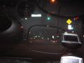
The Lions Gate Bridge.
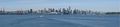
Vancouver!
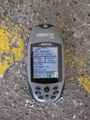
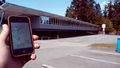
Wildly inaccurate GPS shot.
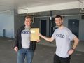
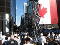
thepiguy hand-delivers the final calendar!
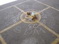
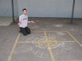
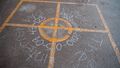
That ought to make some school teachers a little nervous!
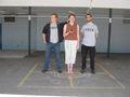
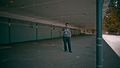
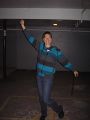
Happy hashers.
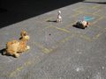
Hahscotch?
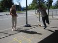
Xore decides to take a turn.
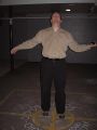
"Wait. I remember this game being bigger. Was I really that small?!?"


Arbron
Arbron's hand at the hash.
Arbron at the hash.
Signs left by others.


Wade & Robyn
And then even later, twelve minutes into the next day, along came Wade and Robyn. I'm categorizing these in the Meetup on 2010-05-09 category because the expedition was launched and attempted on the correct day.
We raced through the night ...
but the seconds ticked down to midnight about 400 metres from the geohash ...
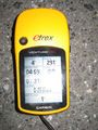
... so we got there slightly late.
Robyn was nevertheless pleased to reach the geohash.
Wade's maniacal laughter is actually at Robyn for having the camera stuck in self-timer mode.
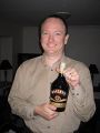
That had better be a really good bottle of Bailey's.


