Difference between revisions of "2010-05-21 49 8"
imported>Koepfel (→Expedition Report: shiny geohashing day ribbon) |
imported>Koepfel (+report) |
||
| Line 21: | Line 21: | ||
=== [[User:Koepfel|Koepfel]]=== | === [[User:Koepfel|Koepfel]]=== | ||
| − | I | + | The algorithm choose this easy reachable hashpoint for 2010's Geohashing Day. How to get there? There were many possibilities, e g. a bus goes directly to the Emil-Arheit-Halle. I could have even used the S4 Stadtbahn line to get to Grötzingen station and take this bus from there, thus keeping up my S4-related Geohashes, as I used said line for my last 4 expeditions. However, this was too close to simply do another public transport expedition, so biking? That was my first idea, but 6 kilometers seemed even walkable. The only other transport method that I didn't do yet and that seemed possible was by taxi, as there is a night-taxi service in Grötzingen that can be used for free if you have a normal public transport ticket, so that wouldn't even cost me anything more. However, this night-taxi only run from 1:00-5:00 and the idea to use it only came to me during the day, so too late. |
| + | |||
| + | So I walked. I took a photo every 5 minutes: | ||
| + | |||
| + | <gallery> | ||
| + | File:2010-05-21 49 8-walk00.jpg|15:00: The street I live in. | ||
| + | File:2010-05-21 49 8-walk05.jpg|15:05: Between Rintheim and Hagsfeld. | ||
| + | File:2010-05-21 49 8-walk10.jpg|15:10: On the bridge over the railway line in Hagsfeld. | ||
| + | File:2010-05-21 49 8-walk15.jpg|15:15: In Hagsfeld, Julius-Bender-Straße. | ||
| + | File:2010-05-21 49 8-walk20.jpg|15:20: At the Schäferstraße, revisiting [[2009-07-01 49 8]]. | ||
| + | File:2010-05-21 49 8-walk25.jpg|15:25: Still in Hagsfeld. | ||
| + | File:2010-05-21 49 8-walk30.jpg|15:30: Leaving Hagsfeld, walking up the bridge over the A5 Autobahn. | ||
| + | File:2010-05-21 49 8-walk35.jpg|15:35: On the other side of the Autobahn, turning into some field path. | ||
| + | File:2010-05-21 49 8-walk40.jpg|15:40: Somehwere between fields. | ||
| + | File:2010-05-21 49 8-walk45.jpg|15:45: Now walking parallel to the Heidelberg-Karlsruhe rail line. An IC to Karlsruhe passes by. | ||
| + | File:2010-05-21 49 8-walk50.jpg|15:50: 5 minutes later, a S-Bahn to Karlsruhe. | ||
| + | File:2010-05-21 49 8-walk55.jpg|15:55: The level crossing of the aforemenrioned rail line. | ||
| + | File:2010-05-21 49 8-walk60.jpg|16:00: At the bus stop at the Emil-Arheit-Halle. | ||
| + | </gallery> | ||
| + | |||
| + | From the bus stop, I walked to the actual hall. The hashpoint was located somewhere left of it After a larger GPS dance, I found it by 16:20. Somebody stuck a few pins to a tree at the hashpoint, the perfect place to hang the xkcd marker. I took this [http://www.ustream.tv/recorded/7094057 video] at the hashpoint. A few people walked by, the playing field nearby was unused though, the hall seemed to be locked, a few people played tennis on the nearby courts. Actually, a pretty uneventful geohashing day expedition, so I walked home by 16:40. Pictures and Tracklog of the way back to be uploaded. | ||
{{Geohashing Day | latitude = 49 | longitude = 8 | year = 2010 | coorddate = 2010-05-21 | name = Koepfel }} | {{Geohashing Day | latitude = 49 | longitude = 8 | year = 2010 | coorddate = 2010-05-21 | name = Koepfel }} | ||
Revision as of 15:21, 23 May 2010
| Fri 21 May 2010 in 49,8: 49.0229115, 8.4999128 geohashing.info google osm bing/os kml crox |
Location
In Karlsruhe-Grötzingen, next to a sports hall, the Emil-Arheit-Halle
Participants
Plans
For Geohashing Day, the algorithm has given us these probably easy coordinates. I'll either walk or bike there in the afternoon. If other Karlsruhe geohashers want to join me, do tell. Koepfel talk 18:47, 20 May 2010 (UTC)
- I'll start walking soon, going via Hagsfeld. ETA: around 16:00 Koepfel talk 12:48, 21 May 2010 (UTC)
Expedition Report
Koepfel
The algorithm choose this easy reachable hashpoint for 2010's Geohashing Day. How to get there? There were many possibilities, e g. a bus goes directly to the Emil-Arheit-Halle. I could have even used the S4 Stadtbahn line to get to Grötzingen station and take this bus from there, thus keeping up my S4-related Geohashes, as I used said line for my last 4 expeditions. However, this was too close to simply do another public transport expedition, so biking? That was my first idea, but 6 kilometers seemed even walkable. The only other transport method that I didn't do yet and that seemed possible was by taxi, as there is a night-taxi service in Grötzingen that can be used for free if you have a normal public transport ticket, so that wouldn't even cost me anything more. However, this night-taxi only run from 1:00-5:00 and the idea to use it only came to me during the day, so too late.
So I walked. I took a photo every 5 minutes:
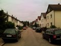
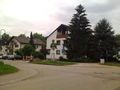
15:00: The street I live in.
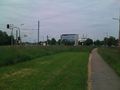
15:05: Between Rintheim and Hagsfeld.
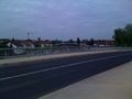
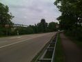
15:10: On the bridge over the railway line in Hagsfeld.
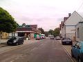
15:15: In Hagsfeld, Julius-Bender-Straße.
15:20: At the Schäferstraße, revisiting 2009-07-01 49 8.
15:25: Still in Hagsfeld.
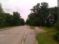
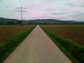
15:30: Leaving Hagsfeld, walking up the bridge over the A5 Autobahn.
15:35: On the other side of the Autobahn, turning into some field path.
15:40: Somehwere between fields.
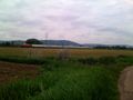
15:45: Now walking parallel to the Heidelberg-Karlsruhe rail line. An IC to Karlsruhe passes by.
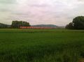
15:50: 5 minutes later, a S-Bahn to Karlsruhe.
15:55: The level crossing of the aforemenrioned rail line.
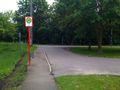
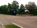
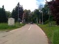
16:00: At the bus stop at the Emil-Arheit-Halle.


From the bus stop, I walked to the actual hall. The hashpoint was located somewhere left of it After a larger GPS dance, I found it by 16:20. Somebody stuck a few pins to a tree at the hashpoint, the perfect place to hang the xkcd marker. I took this video at the hashpoint. A few people walked by, the playing field nearby was unused though, the hall seemed to be locked, a few people played tennis on the nearby courts. Actually, a pretty uneventful geohashing day expedition, so I walked home by 16:40. Pictures and Tracklog of the way back to be uploaded.
Koepfel earned the 2010 Geohashing Day achievement
|