Difference between revisions of "2010-06-24 -36 174"
imported>Greenslime (Created page with '<!-- If you did not specify these parameters in the template, please substitute appropriate things for IMAGE, LAT, LON, and DATE (YYYY-MM-DD format) [[Image:{{{image|IMAGE}}}|t…') |
imported>FippeBot m (Location) |
||
| (11 intermediate revisions by 2 users not shown) | |||
| Line 11: | Line 11: | ||
}} | }} | ||
| − | + | ||
__NOTOC__ | __NOTOC__ | ||
== Location == | == Location == | ||
| Line 25: | Line 25: | ||
== Expedition == | == Expedition == | ||
| − | + | Morning routine:Check hash. Today was one of those days where it didn't land in the water (but very close to). Initially I thought the hash was located on defense property, as they regularly use the tip of the peninsula for exercises. After a particularly drawn out and convuluted research group meeting, combined with a further prod by [[User:JimmyNZ|JimmyNZ]], I was encouraged to take another look, and it turns out the hash fell in Shakespear Regional Park! Excellent. | |
| − | |||
| − | |||
| − | |||
| − | |||
| + | I don't actually own a GPS but aerial views of the hash showed clear terrestrial features that could be used to confirm the location. Armed with a compass, I identified a man-made landmark from which to take a bearing to the hash from, and a farm track to gauge the distance, this one was going to be easy. | ||
| + | Heading up, I had planned to embark on a trail run at the same time, but forgot my shorts, so I ambled at a non-sweat provoking pace up and down a few hills, following the very obvious farm tracks. Scaring a few sheep, peacocks and pukekos along the way, I found the hash, took the photos, enjoyed the view, and headed back down the hills. Too easy, and a nice location for future trail running. | ||
== Tracklog == | == Tracklog == | ||
| Line 39: | Line 37: | ||
<gallery> | <gallery> | ||
| + | File:2010-06-24 -36 174 Aerial View.JPG|Google Maps aerial view of the hash. | ||
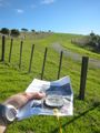
| + | File:2010-06-24 -36 174 Man made object.jpg|Visible in aerial view, not sure what this was, looks like a gun emplacement with its spectacular views over the ocean. | ||
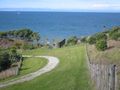
| + | File:2010-06-24 -36 174 That direction.jpg|Hash is that direction, roughly. | ||
| + | File:2010-06-24 -36 174 Farm Track as seen on map.jpg|Farm track, as seen in aerial view. | ||
| + | File:2010-06-24 -36 174 Mad made object and hash point.jpg|Man made object. The hashpoint is over my left shoulder. | ||
| + | File:2010-06-24 -36 174 Water Feeder.jpg|Water distributor, as seen in aerial view. | ||
| + | File:2010-06-24 -36 174 Token Sheep.jpg|The wildlife, apparently what NZ is known for. | ||
| + | File:2010-06-24 -36 174 Shakespear Regional Park.jpg|A piece of beautiful NZ. | ||
| + | </gallery> | ||
| + | == Hash Awards == | ||
| + | {{Last man standing | ||
| + | | latitude = -36 | ||
| + | | longitude = 174 | ||
| + | | date = 2010-06-24 | ||
| + | | gender = chick | ||
| + | | name = [[User:Greenslime|Greenslime]] | ||
| + | | image = 2010-06-24 -36 174 Water Feeder.jpg | ||
| + | }} | ||
| − | + | {{Land geohash | |
| − | + | | latitude = -36 | |
| − | == | + | | longitude = 174 |
| + | | date = 2010-06-24 | ||
| + | | name = [[User:Greenslime|Greenslime]] | ||
| + | }} | ||
{{No_batteries_geohash | {{No_batteries_geohash | ||
| latitude = -36 | | latitude = -36 | ||
| − | | longitude = | + | | longitude = 174 |
| − | | date = | + | | date = 2010-06-24 |
| − | | name = | + | | name = [[User:Greenslime|Greenslime]] |
| − | | image = | + | | image = 2010-06-24 -36 174 That direction.jpg |
}} | }} | ||
| − | + | ||
[[Category:Coordinates reached]][[Category:Expeditions with photos]][[Category:Expeditions]] | [[Category:Coordinates reached]][[Category:Expeditions with photos]][[Category:Expeditions]] | ||
| + | {{location|NZ|AUK}} | ||
Latest revision as of 02:31, 9 August 2019
| Thu 24 Jun 2010 in -36,174: -36.6137949, 174.8354196 geohashing.info google osm bing/os kml crox |
Location
Shakespear Regional Park, Whangaparoa Peninsula, Auckland, New Zealand
Participants
Plans
Skip half day at work/uni, jump in car and head up to Whangaparoa Peninsula - the area is one of my favourite longlining spots.
Expedition
Morning routine:Check hash. Today was one of those days where it didn't land in the water (but very close to). Initially I thought the hash was located on defense property, as they regularly use the tip of the peninsula for exercises. After a particularly drawn out and convuluted research group meeting, combined with a further prod by JimmyNZ, I was encouraged to take another look, and it turns out the hash fell in Shakespear Regional Park! Excellent.
I don't actually own a GPS but aerial views of the hash showed clear terrestrial features that could be used to confirm the location. Armed with a compass, I identified a man-made landmark from which to take a bearing to the hash from, and a farm track to gauge the distance, this one was going to be easy.
Heading up, I had planned to embark on a trail run at the same time, but forgot my shorts, so I ambled at a non-sweat provoking pace up and down a few hills, following the very obvious farm tracks. Scaring a few sheep, peacocks and pukekos along the way, I found the hash, took the photos, enjoyed the view, and headed back down the hills. Too easy, and a nice location for future trail running.
Tracklog
SH1 north to Silverdale offramp, down Whangaparoa Peninsula to the end, last right to Shakespear Regional Park. Then take all the available lefts to get over the headland and park at the gate to the campground.
Photos
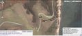
Google Maps aerial view of the hash.
Visible in aerial view, not sure what this was, looks like a gun emplacement with its spectacular views over the ocean.
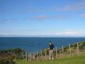
Hash is that direction, roughly.
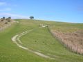
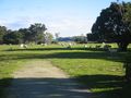
Farm track, as seen in aerial view.
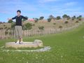
Man made object. The hashpoint is over my left shoulder.
Water distributor, as seen in aerial view.
The wildlife, apparently what NZ is known for.
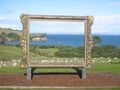
A piece of beautiful NZ.


Hash Awards
Greenslime earned the Last chick standing achievement
|
Greenslime earned the Land geohash achievement
|
Greenslime earned the No Batteries Geohash Achievement
|