2010-07-05 35 -105
From Geohashing
Revision as of 02:12, 6 July 2010 by imported>Redaragorn (Created page with '{{meetup graticule | map=<map lat="35" lon="-105" date="2010-07-05" /> | lat=35 | lon=-105 | date=2010-07-05 }} == Location == In a stand of pinons in the tract of National For…')
| Mon 5 Jul 2010 in 35,-105: 35.4697853, -105.7430819 geohashing.info google osm bing/os kml crox |
Location
In a stand of pinons in the tract of National Forest land south of the town of Pecos
Participants
- Redaragorn and family
Plans
I knew I had the day free and wanted to hang out with the family, so I was looking to see what hashes would be doable. The local one was close, but on Zia land. Santa Fe was the next logical choice because it was close enough and looked moderately accessible. The dirt roads to get to a particular spot are always a bit of a wildcard, but I figured it was worth a try. At the very worst, we'd find ourselves out in a pretty spot to spend the day.
Expedition
Track
Check out the track here.
Pictures
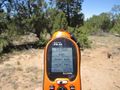
GPS coordinates to prove we were there.
- 2010-07-05 35 -105 - memorial.jpg
XKCD memorial built of dead pinon branches.
- 2010-07-05 35 -105 - boys.jpg
The boys hanging out on the hash spot.

Picture of the whole family.

