2010-07-05 35 -105
| Mon 5 Jul 2010 in 35,-105: 35.4697853, -105.7430819 geohashing.info google osm bing/os kml crox |
Location
In a stand of pinons in the tract of National Forest land south of the town of Pecos
Participants
- Redaragorn and family
Plans
I knew I had the day free and wanted to hang out with the family, so I was looking to see what hashes would be doable. The local one was close, but on Zia land. Santa Fe was the next logical choice because it was close enough and looked moderately accessible. The dirt roads to get to a particular spot are always a bit of a wildcard, but I figured it was worth a try. At the very worst, we'd find ourselves out in a pretty spot to spend the day.
Expedition
Got in a decent run first thing this morning, then was moving slowly so we didn't get out the door with the family until after 9:30a. The drive up to Santa Fe was uneventful enough, although traffic was a little heavier than usual. I attribute that to the holiday weekend hangover. We got headed south on the county road that approached the hash from the west side, but came to a couple of dead ends at private property that blocked access to the National Forest land.
Track
Check out the track here.
Pictures
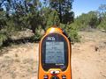
GPS coordinates to prove we were there.
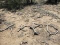
XKCD memorial built of dead pinon branches.

The boys hanging out on the hash spot.

Picture of the whole family.


