Difference between revisions of "2010-07-08 50 -119"
imported>Robyn (You guessed it.) |
m (More specific location) |
||
| (4 intermediate revisions by 3 users not shown) | |||
| Line 1: | Line 1: | ||
| − | + | This may be my personal record for closest geohash to the location at which I discovered the coordinates. | |
| − | [[Image: | + | [[Image:2010-07-08 50 -119.fromdeck.jpg|thumb|left]] |
| − | |||
| − | |||
{{meetup graticule | {{meetup graticule | ||
| lat=50 | | lat=50 | ||
| Line 11: | Line 9: | ||
}} | }} | ||
| − | + | ||
__NOTOC__ | __NOTOC__ | ||
== Location == | == Location == | ||
| − | + | Just across the railroad tracks from a Salmon Arm waterfront nesting bird preserve, and 378 metres from my mother's deck. | |
| − | |||
| − | |||
== Participants == | == Participants == | ||
| − | + | * [[User:Robyn|Robyn]], initially appearing as a random IP address. | |
| − | * [[User:Robyn|Robyn]], | ||
== Plans == | == Plans == | ||
| − | + | Run out before breakfast and find the point under the guise of a morning walk. It seemed to be on quite a steep hill and near a railroad track, so I wasn't sure about access. | |
== Expedition == | == Expedition == | ||
| − | + | I went online to see if there was a geohash compatible with my drive from Salmon Arm to Vancouver, but instead there was one right outside my door. If my mother were a geohasher she'd be posting a Couch Potato Honourable Mention Ribbon right now. Well actually she wouldn't. She'd be glaring suspiciously at Firefox and asking me how to get it to stop asking her to update. From version 3.0. | |
| − | |||
| + | Salmon Arm has numbered streets and avenues, but they are kind of randomly numbered, as they aren't in a grid pattern at all. So I started on 18th Street NE and walked along it while it became 15th Avenue NE and then 16th Street NE. If I'd gone further it would have intersected 11th Avenue NE (I'm not making this up) but I found a trail that promised to take me to Lakeshore Road, which not only had a real name, but was very close to where I wanted to go. The path did as promised, and then I found another path, with switchbacks, taking me over the edge of the embankment to within twenty paces of the geohash itself. | ||
| + | It switched back just before reaching the geohash, so I took those few paces into the grass without falling into any holes and captured the point. I then continued down the path, across the railroad tracks and over a bridge onto a wooded trail. The first thing I saw there was a group of about eleven immature ducks, too well-feathered to be called ducklings anymore, and too fast moving for me to get out my camera in time, all following one another into a foliage-screened ditch. Kind of made me wonder if ducks eventually undergo some duck adolescence, when they stop following each other around single file and start rebelling to become their own independent ducks. | ||
| − | + | I walked along the trail until it ended, at a gate that said it was a waterfowl preserve, and then went back up the hill for breakfast. | |
| − | |||
== Photos == | == Photos == | ||
| − | |||
| − | |||
| − | |||
<gallery perrow="5"> | <gallery perrow="5"> | ||
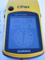
| + | Image:2010-07-08 50 -119.gpsfromdeck.jpg| Closest ever point to my starting point. | ||
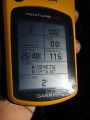
| + | Image:2010-07-08 50 -119.gps.jpg|And I found it ... | ||
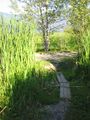
| + | Image:2010-07-08 50 -119.grin.jpg|... despite the sun in my eyes. | ||
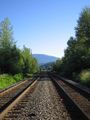
| + | Image:2010-07-08 50 -119.tracks.jpg|Then went across the tracks ... | ||
| + | Image:2010-07-08 50 -119.bridge.jpg|... and over a bridge. | ||
</gallery> | </gallery> | ||
== Achievements == | == Achievements == | ||
{{#vardefine:ribbonwidth|800px}} | {{#vardefine:ribbonwidth|800px}} | ||
| − | |||
| + | {{Land geohash | ||
| + | | latitude = 50 | ||
| + | | longitude = -119 | ||
| + | | date = 2010-07-08 | ||
| + | | name = [[User:Robyn|Robyn]] | ||
| + | }} | ||
| − | + | {{Walk geohash | |
| − | + | | latitude = 50 | |
| − | [[ | + | | longitude = -119 |
| + | | date = 2010-07-08 | ||
| + | | name = [[User:Robyn|Robyn]] | ||
| + | }} | ||
[[Category:Expeditions]] | [[Category:Expeditions]] | ||
| − | |||
| − | |||
| − | |||
[[Category:Expeditions with photos]] | [[Category:Expeditions with photos]] | ||
| − | |||
| − | |||
| − | |||
| − | |||
| − | |||
[[Category:Coordinates reached]] | [[Category:Coordinates reached]] | ||
| + | {{location|CA|BC|CS}} | ||
Latest revision as of 23:26, 9 August 2020
This may be my personal record for closest geohash to the location at which I discovered the coordinates.

| Thu 8 Jul 2010 in 50,-119: 50.7129432, -119.2686770 geohashing.info google osm bing/os kml crox |
Location
Just across the railroad tracks from a Salmon Arm waterfront nesting bird preserve, and 378 metres from my mother's deck.
Participants
- Robyn, initially appearing as a random IP address.
Plans
Run out before breakfast and find the point under the guise of a morning walk. It seemed to be on quite a steep hill and near a railroad track, so I wasn't sure about access.
Expedition
I went online to see if there was a geohash compatible with my drive from Salmon Arm to Vancouver, but instead there was one right outside my door. If my mother were a geohasher she'd be posting a Couch Potato Honourable Mention Ribbon right now. Well actually she wouldn't. She'd be glaring suspiciously at Firefox and asking me how to get it to stop asking her to update. From version 3.0.
Salmon Arm has numbered streets and avenues, but they are kind of randomly numbered, as they aren't in a grid pattern at all. So I started on 18th Street NE and walked along it while it became 15th Avenue NE and then 16th Street NE. If I'd gone further it would have intersected 11th Avenue NE (I'm not making this up) but I found a trail that promised to take me to Lakeshore Road, which not only had a real name, but was very close to where I wanted to go. The path did as promised, and then I found another path, with switchbacks, taking me over the edge of the embankment to within twenty paces of the geohash itself.
It switched back just before reaching the geohash, so I took those few paces into the grass without falling into any holes and captured the point. I then continued down the path, across the railroad tracks and over a bridge onto a wooded trail. The first thing I saw there was a group of about eleven immature ducks, too well-feathered to be called ducklings anymore, and too fast moving for me to get out my camera in time, all following one another into a foliage-screened ditch. Kind of made me wonder if ducks eventually undergo some duck adolescence, when they stop following each other around single file and start rebelling to become their own independent ducks.
I walked along the trail until it ended, at a gate that said it was a waterfowl preserve, and then went back up the hill for breakfast.
Photos
Closest ever point to my starting point.
And I found it ...

... despite the sun in my eyes.
Then went across the tracks ...
... and over a bridge.


Achievements
Robyn earned the Land geohash achievement
|
Robyn earned the Walk geohash Achievement
|