Difference between revisions of "2010-07-13 -36 174"
imported>Benjw (don't need new report cat for this one) |
imported>Jiml m (Tweak formatting and typos) |
||
| Line 1: | Line 1: | ||
| − | |||
| − | |||
| − | |||
| − | |||
| − | |||
| − | |||
{{meetup graticule | {{meetup graticule | ||
| lat=-36 | | lat=-36 | ||
| Line 11: | Line 5: | ||
}} | }} | ||
| − | |||
__NOTOC__ | __NOTOC__ | ||
== Location == | == Location == | ||
| − | + | Mangere South, Auckland. Google maps shows it to be an undeveloped section, right on the Manukau Harbour. | |
| − | Mangere South, Auckland. Google maps shows it to be an undeveloped section, right on the Manukau Harbour. Am wondering if the map is old and there is indeed a house on the section now. The hash is very close to a cemetery. | + | |
| + | Am wondering if the map is old and there is indeed a house on the section now. The hash is very close to a cemetery. | ||
== Participants == | == Participants == | ||
| − | + | * [[user:Greenslime|Greenslime]] | |
| − | [[user:Greenslime|Greenslime]] | ||
== Plans == | == Plans == | ||
| − | + | Drive there after work. (Leave work around 15:00) Have no camera so will be crappy phone images. Also have no GPS so will be no batteries, coupled with good old Google map printouts. | |
| − | Drive there after work. (Leave work around 15:00) Have no camera so will be crappy phone images. Also have no GPS so will be no batteries, coupled with good | ||
== Expedition == | == Expedition == | ||
| − | + | ||
| − | School holidays means less people on the road, so | + | School holidays means less people on the road, so I thought. Took 15 mins driving to get to the hash from my work place, and about an hour to get home, grizzle grizzle. |
| + | |||
| + | This hash took me to another area of Auckland i had never been before, about 3 km from Auckland International Airport. The area was reasonably underdeveloped, with a vineyard down the road. Hash point was on an undeveloped section overlooking a Maori cemetery (urupa), hence the piece of land was probably of some significance to maori. There was a maori meeting place (marae) down the road. | ||
| + | |||
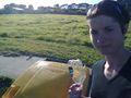
| + | I parked up, walked onto the section and aligned myself with the garage of the neighbouring section approximately 8 m from the boundary (as calculated using Google earth satellite images). I took the token photos using my cell phone camera (quality of the images was not too shabby either), picked up a piece of trash and placed in a recycling receptacle conveniently position on the side of the road. | ||
| + | |||
| + | That's it, too easy, and i only lost an hour and a half out of my day. The unique view of the Manukau Harbour mouth and the Waitakere Ranges was worth the trip. | ||
== Tracklog == | == Tracklog == | ||
| − | |||
Drove a route to Auckland International Airport, turned right at Ascot rd, hash was on Waipouri rd. | Drove a route to Auckland International Airport, turned right at Ascot rd, hash was on Waipouri rd. | ||
== Photos == | == Photos == | ||
| − | + | ||
| − | |||
| − | |||
<gallery perrow="5"> | <gallery perrow="5"> | ||
| − | |||
| − | |||
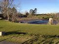
File:2010-07-13 -36 174 Manukau Harbour.jpg|The beautiful muddy Manukau Harbour and Waitakere Ranges in the background | File:2010-07-13 -36 174 Manukau Harbour.jpg|The beautiful muddy Manukau Harbour and Waitakere Ranges in the background | ||
| Line 51: | Line 44: | ||
== Achievements == | == Achievements == | ||
{{#vardefine:ribbonwidth|800px}} | {{#vardefine:ribbonwidth|800px}} | ||
| − | + | ||
{{Geotrash | {{Geotrash | ||
| latitude = -36 | | latitude = -36 | ||
| Line 68: | Line 61: | ||
| image = 2010-07-13 -36 174 Waipouri Road.jpg | | image = 2010-07-13 -36 174 Waipouri Road.jpg | ||
}} | }} | ||
| + | |||
| + | * Land Geohash | ||
[[Category:Coordinates reached]] | [[Category:Coordinates reached]] | ||
Revision as of 00:05, 25 July 2010
| Tue 13 Jul 2010 in -36,174: -36.9838408, 174.7670822 geohashing.info google osm bing/os kml crox |
Location
Mangere South, Auckland. Google maps shows it to be an undeveloped section, right on the Manukau Harbour.
Am wondering if the map is old and there is indeed a house on the section now. The hash is very close to a cemetery.
Participants
Plans
Drive there after work. (Leave work around 15:00) Have no camera so will be crappy phone images. Also have no GPS so will be no batteries, coupled with good old Google map printouts.
Expedition
School holidays means less people on the road, so I thought. Took 15 mins driving to get to the hash from my work place, and about an hour to get home, grizzle grizzle.
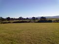
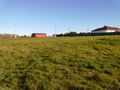
This hash took me to another area of Auckland i had never been before, about 3 km from Auckland International Airport. The area was reasonably underdeveloped, with a vineyard down the road. Hash point was on an undeveloped section overlooking a Maori cemetery (urupa), hence the piece of land was probably of some significance to maori. There was a maori meeting place (marae) down the road.
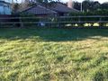
I parked up, walked onto the section and aligned myself with the garage of the neighbouring section approximately 8 m from the boundary (as calculated using Google earth satellite images). I took the token photos using my cell phone camera (quality of the images was not too shabby either), picked up a piece of trash and placed in a recycling receptacle conveniently position on the side of the road.
That's it, too easy, and i only lost an hour and a half out of my day. The unique view of the Manukau Harbour mouth and the Waitakere Ranges was worth the trip.
Tracklog
Drove a route to Auckland International Airport, turned right at Ascot rd, hash was on Waipouri rd.
Photos
The beautiful muddy Manukau Harbour and Waitakere Ranges in the background
View of the hashpoint directly in front.
View from the hash
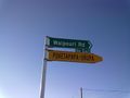
Road sign evidence of my presence
Yup, Auckland is indeed surrounded by water
Token piece of geotrash placed into the appropriatly positioned Manukau City Council recycling bin


Achievements
Greenslime earned the GeoTrash Geohash Achievement
|
Greenslime earned the No Batteries Geohash Achievement
|
- Land Geohash