Difference between revisions of "2010-07-30 45 -122"
imported>Michael5000 (Created page with '{{subst:Expedition |lat = 45 |lon = -122 |date = 2010-07-30 }}') |
imported>FippeBot m (Location) |
||
| (17 intermediate revisions by 4 users not shown) | |||
| Line 1: | Line 1: | ||
| + | [[Image:{{{image|2010-07-30_45_-122_19-54-23-387.jpg}}}|thumb|left]] | ||
| − | |||
| − | |||
| − | |||
| − | |||
| − | |||
| − | |||
| − | |||
| − | |||
{{meetup graticule | {{meetup graticule | ||
| lat=45 | | lat=45 | ||
| Line 15: | Line 8: | ||
}} | }} | ||
| − | + | ||
__NOTOC__ | __NOTOC__ | ||
== Location == | == Location == | ||
| − | + | ||
| + | On the campus of Lakeridge High School, in Lake Oswego. | ||
== Participants == | == Participants == | ||
| − | + | ||
| + | * [[User:Michael5000|Michael5000]] | ||
| + | * [[User:Aperfectring|APR]] | ||
| + | * [[User:Jiml|Jim]] | ||
== Plans == | == Plans == | ||
| − | + | ||
| + | Michael5000 will try to ride out to this site at, hmm, around mid-day. And if it's a quiet, deserted summer campus, maybe he'll hang out and read for a while. Although, if it's an active campus, he'll probably just try to get to the spot and then split. | ||
| + | |||
| + | APR will try to get out of work and be ready to do some traveling by 6PM, which should put him at the hashpoint between 6:30 and 7, but probably closer to 7, given that he'll have to take the interstates on a Friday. | ||
| + | |||
| + | For APR's ease of calculation later: | ||
| + | {{PBGH battleship | lat = 45 | lon = -122 | date = 2010-07-30}} | ||
== Expedition == | == Expedition == | ||
| − | |||
| − | == | + | ===Expedition5000=== |
| − | + | ||
| + | I rode south along the Willamette River Trail and took my chances on the Sellwood Bridge before cycling up through Riverview Cemetery. I remember this climb as a real bear when I was riding it weekly at 31, so it was gratifying to have it be no big deal at 41. Take that, wimpy younger self! From the Lewis and Clark area, I rode around the north and east sides of Oregon's most exclusive mill pond, sneaking up on the hashpoint from the back as it were and finding it with no trouble at all. I spent a little time there writing postcards, and left one for anyone else who comes along, although I imagine the school staff will get to it first. | ||
| + | |||
| + | From downtown Lake O I followed Terwilliger all the way to downtown downtown, crossed back over the Hawthorne, and found my way home without difficulty. 31.0 miles all in all -- the furthest I've ridden on a successful expedition. | ||
| + | |||
| + | ===Expedition APR & Jim=== | ||
| + | *About to get under way! -- [[User:Aperfectring|aperfectring]] [http://www.openstreetmap.org/?lat=45.528532&lon=-122.960136&zoom=16&layers=B000FTF @45.5285,-122.9601] 00:58, 31 July 2010 (UTC) | ||
| + | |||
| + | Jim and APR met up at APR's place around 6PM. Since Jim had an aging, and possibly unreliable, vehicle, APR drove. They took a nice drive through the farmlands of the Tualatin Valley, winding around and finally making a steep climb up Overlook Drive to the high school. | ||
| + | |||
| + | The GPS's worked fine until we got close to the building, where they started to act a little odd. At one point, the | ||
| + | hashpoint "moved" from a couple of feet away to 30 feet. There was a pretty clear view of half the sky, except for | ||
| + | the building which was blocking the portion behind us. | ||
| + | |||
| + | Once at the high school, we graciously accepted Michael's hashcard, and left a more comprehensive note explaining geohashing, and including APR's battleship shot which hopefully shall begin the demolition of relet's ships. After visiting the hashpoint, Jim and APR headed off for some dinner, which they got at a pizzeria in Lake Oswego. On the way back, they again drove through rural Tualatin Valley, and saw a beautiful sunset of the hills/mountains to the west. | ||
== Photos == | == Photos == | ||
| − | + | ||
| − | |||
| − | |||
<gallery perrow="5"> | <gallery perrow="5"> | ||
| + | |||
| + | Image:2010-07-30_45_-122-area.jpg | A view of the area | ||
| + | |||
| + | Image:2010-07-30_45_-122_18-56-53-344.jpg | Success and a hashcard! [http://www.openstreetmap.org/?lat=45.39747498333333&lon=-122.69324186666667&zoom=16&layers=B000FTF @45.3975,-122.6932] | ||
| + | |||
| + | |||
| + | Image:2010-07-30_45_-122_apr_01.jpg | The wonderful hashcard graciously left by Michael5000 | ||
| + | |||
| + | Image:2010-07-30_45_-122_apr_03.jpg | Jiml at the hashpoint. | ||
| + | Image:2010-07-30_45_-122-APR1.jpg | APR At the hashpoint | ||
| + | Image:2010-07-30_45_-122-GPS2.jpg | A GPS made it to the hashpoint | ||
| + | Image:2010-07-30_45_-122_apr_02.jpg | The not nearly as wonderful, but more descriptive hashpoint marker left by APR | ||
| + | Image:2010-07-30_45_-122_19-54-23-387.jpg | Delicious pizza consumed a scant 1.5 miles from the hashpoint @ Deno's Pizzeria [http://www.openstreetmap.org/?lat=45.4044&lon=-122.7230&zoom=16&layers=B000FTF @45.4044,-122.7230] | ||
| + | |||
</gallery> | </gallery> | ||
== Achievements == | == Achievements == | ||
{{#vardefine:ribbonwidth|800px}} | {{#vardefine:ribbonwidth|800px}} | ||
| − | |||
| + | * Land Geohash | ||
| − | |||
| − | |||
| − | |||
| − | |||
| − | |||
| − | |||
| − | |||
| − | + | [[Category:Expeditions]][[Category:Expeditions with photos]] | |
| − | [[Category:Expeditions]] | + | |
| − | |||
| − | [[Category:Expeditions with photos]] | ||
| − | |||
| − | |||
| − | |||
| − | |||
| − | |||
[[Category:Coordinates reached]] | [[Category:Coordinates reached]] | ||
| − | + | {{location|US|OR|CC}} | |
| − | |||
| − | |||
| − | |||
| − | |||
| − | |||
| − | |||
| − | |||
| − | |||
| − | |||
Latest revision as of 03:01, 9 August 2019

| Fri 30 Jul 2010 in 45,-122: 45.3974402, -122.6929994 geohashing.info google osm bing/os kml crox |
Location
On the campus of Lakeridge High School, in Lake Oswego.
Participants
Plans
Michael5000 will try to ride out to this site at, hmm, around mid-day. And if it's a quiet, deserted summer campus, maybe he'll hang out and read for a while. Although, if it's an active campus, he'll probably just try to get to the spot and then split.
APR will try to get out of work and be ready to do some traveling by 6PM, which should put him at the hashpoint between 6:30 and 7, but probably closer to 7, given that he'll have to take the interstates on a Friday.
For APR's ease of calculation later: Today's battleship location is: D 4
Expedition
Expedition5000
I rode south along the Willamette River Trail and took my chances on the Sellwood Bridge before cycling up through Riverview Cemetery. I remember this climb as a real bear when I was riding it weekly at 31, so it was gratifying to have it be no big deal at 41. Take that, wimpy younger self! From the Lewis and Clark area, I rode around the north and east sides of Oregon's most exclusive mill pond, sneaking up on the hashpoint from the back as it were and finding it with no trouble at all. I spent a little time there writing postcards, and left one for anyone else who comes along, although I imagine the school staff will get to it first.
From downtown Lake O I followed Terwilliger all the way to downtown downtown, crossed back over the Hawthorne, and found my way home without difficulty. 31.0 miles all in all -- the furthest I've ridden on a successful expedition.
Expedition APR & Jim
- About to get under way! -- aperfectring @45.5285,-122.9601 00:58, 31 July 2010 (UTC)
Jim and APR met up at APR's place around 6PM. Since Jim had an aging, and possibly unreliable, vehicle, APR drove. They took a nice drive through the farmlands of the Tualatin Valley, winding around and finally making a steep climb up Overlook Drive to the high school.
The GPS's worked fine until we got close to the building, where they started to act a little odd. At one point, the hashpoint "moved" from a couple of feet away to 30 feet. There was a pretty clear view of half the sky, except for the building which was blocking the portion behind us.
Once at the high school, we graciously accepted Michael's hashcard, and left a more comprehensive note explaining geohashing, and including APR's battleship shot which hopefully shall begin the demolition of relet's ships. After visiting the hashpoint, Jim and APR headed off for some dinner, which they got at a pizzeria in Lake Oswego. On the way back, they again drove through rural Tualatin Valley, and saw a beautiful sunset of the hills/mountains to the west.
Photos
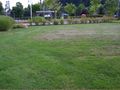
A view of the area
Success and a hashcard! @45.3975,-122.6932
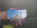
The wonderful hashcard graciously left by Michael5000

Jiml at the hashpoint.
APR At the hashpoint
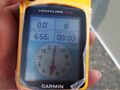
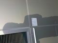
A GPS made it to the hashpoint
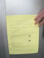
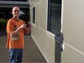
The not nearly as wonderful, but more descriptive hashpoint marker left by APR
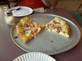
Delicious pizza consumed a scant 1.5 miles from the hashpoint @ Deno's Pizzeria @45.4044,-122.7230


Achievements
- Land Geohash