Difference between revisions of "2010-08-11 52 1"
imported>Sourcerer m (→More Links) |
imported>Sourcerer m (→Corrected format) |
||
| Line 9: | Line 9: | ||
== Location == | == Location == | ||
| − | In a wheat field north of Laxfield, Suffolk, United Kingdom | + | In a wheat field north of Laxfield, Suffolk, United Kingdom. |
| − | |||
| − | |||
== Participants == | == Participants == | ||
| Line 20: | Line 18: | ||
[[User:Sourcerer|Sourcerer]] (Neil) went on a 5 mile walk starting and ending in Laxfield with a convenient pub at the end of the walk. | [[User:Sourcerer|Sourcerer]] (Neil) went on a 5 mile walk starting and ending in Laxfield with a convenient pub at the end of the walk. | ||
| + | |||
| + | The hash point was on a public footpath path and easy to get to. There is a GPS path here at [http://www.wikiloc.com/wikiloc/view.do?id=1095231 wikiloc]. | ||
| + | |||
| + | The return route was less easy. Although using public footpaths, there were three deep un-bridged drainage ditches to negotiate. These needed some agility and a willingness to ignore water, mud, nettles and thistles. It was obvious from the vegetation that others had performed a glassade (a glissade performed by sliding on ones rear end) in order to cross the ditches. | ||
== Image Gallery == | == Image Gallery == | ||
Revision as of 08:31, 20 October 2015
| Wed 11 Aug 2010 in Norwich: 52.3196175, 1.3508862 geohashing.info google osm bing/os kml crox |
Contents
Location
In a wheat field north of Laxfield, Suffolk, United Kingdom.
Participants
Expedition
Sourcerer (Neil) went on a 5 mile walk starting and ending in Laxfield with a convenient pub at the end of the walk.
The hash point was on a public footpath path and easy to get to. There is a GPS path here at wikiloc.
The return route was less easy. Although using public footpaths, there were three deep un-bridged drainage ditches to negotiate. These needed some agility and a willingness to ignore water, mud, nettles and thistles. It was obvious from the vegetation that others had performed a glassade (a glissade performed by sliding on ones rear end) in order to cross the ditches.
Image Gallery
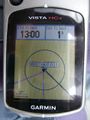
Satnav Evidence.
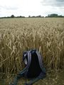
Wheat Field 1.
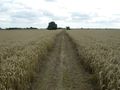
Wheat Field 2.
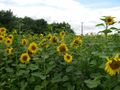
Sun Flower Field.


Expeditions and Plans
| 2010-08-11 | ||
|---|---|---|
| Atlanta, Georgia | NWoodruff | Just west of the Atlanta Airport in East Point. |
| Greeley, Colorado | Hoozer | 9 miles (14.5 km) west of Briggsdale, CO in the Pawnee National Grassland. |
| Newark, New Jersey | Kyukket | In the woods near Saw Mill Rd., in Warren Township. |
| Mannheim, Germany | Fivetonsofflax | In a corn field near Hanhofen |
| Cambridge, United Kingdom | Benjw | In a field just outside Soham village, between Ely and Newmarket. |
| Norwich, United Kingdom | Sourcerer | In a wheat field north of Laxfield, Suffolk, United Kingdom. |
| Rovaniemi, Finland | isopekka | About 25 km south from the city of Rovaniemi, Finland. Nollapiste sijaitse... |
Sourcerer's Expedition Links
2010-08-10 51 0 - 2010-08-11 52 1 - 2010-08-13 52 1 - KML file download of Sourcerer's expeditions for use with Google Earth.