Difference between revisions of "2010-10-03 66 25"
From Geohashing
imported>Isopekka |
imported>FippeBot m (Location) |
||
| (5 intermediate revisions by 2 users not shown) | |||
| Line 1: | Line 1: | ||
<!-- If you did not specify these parameters in the template, please substitute appropriate things for IMAGE, LAT, LON, and DATE (YYYY-MM-DD format) | <!-- If you did not specify these parameters in the template, please substitute appropriate things for IMAGE, LAT, LON, and DATE (YYYY-MM-DD format) | ||
| − | [[Image: | + | [[Image:Gd2+gh9 009.JPG|thumb|left]] |
Remove this section if you don't want a image at the top (left) of your report. You should remove the "Image:" or "File:" | Remove this section if you don't want a image at the top (left) of your report. You should remove the "Image:" or "File:" | ||
| Line 8: | Line 8: | ||
And DON'T FORGET to add your expedition and the best photo you took to the gallery on the Main Page! We'd love to read your report, but that means we first have to discover it! | And DON'T FORGET to add your expedition and the best photo you took to the gallery on the Main Page! We'd love to read your report, but that means we first have to discover it! | ||
--> | --> | ||
| + | [[Image:Gd2+gh9 009.JPG|thumb|left]] | ||
| + | |||
{{meetup graticule | {{meetup graticule | ||
| lat=66 | | lat=66 | ||
| Line 46: | Line 48: | ||
<Gallery> | <Gallery> | ||
| + | Image:Gh9.jpg| From the road downhill and then across the marsh. No, we do not have snow yet! | ||
Image:Gd2+gh9 007.JPG| 800 m to the point. Maybe there are birds to hunt on the way... | Image:Gd2+gh9 007.JPG| 800 m to the point. Maybe there are birds to hunt on the way... | ||
Image:Gd2+gh9 008.JPG| 200 m to the Hash, right across the wet marsh. | Image:Gd2+gh9 008.JPG| 200 m to the Hash, right across the wet marsh. | ||
| Line 57: | Line 60: | ||
</Gallery> | </Gallery> | ||
| + | |||
| + | |||
== Achievements == | == Achievements == | ||
| + | {{land geohash | ||
| + | | latitude = 66 | ||
| + | | longitude = 25 | ||
| + | | date = 2010-10-03 | ||
| + | | name = isopekka | ||
| + | |||
}} | }} | ||
| + | |||
| + | |||
| + | |||
| + | == Other Geohashing Expeditions and Plans on This Day == | ||
| + | |||
| + | {{expedition summaries|2010-10-03}} | ||
| + | |||
| + | |||
[[Category:Expeditions]] | [[Category:Expeditions]] | ||
| − | [[Category: | + | [[Category:Expeditions with photos]] |
| + | |||
| + | [[Category:Coordinates reached]] | ||
| + | {{location|FI|10}} | ||
Latest revision as of 04:00, 9 August 2019

| Sun 3 Oct 2010 in 66,25: 66.8362717, 25.6914929 geohashing.info google osm bing/os kml crox |
Contents
Location
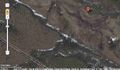
About 40 km N from Rovaniemi, 10 km E from the village Patokoski, Finland. Point is in the wilderness.
Participants
- isopekka & Tintti & dog
Expedition
I reached the hashpoint at 02:00 p.m.
- Walking total 1.6 km
- By car total about 100 km
- Expedition took 3 hours
- Physical efforts needed (1-5): 3
Photos
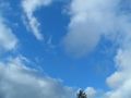
From the road downhill and then across the marsh. No, we do not have snow yet!
800 m to the point. Maybe there are birds to hunt on the way...
200 m to the Hash, right across the wet marsh.
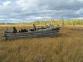
70 m to the Hash from this ex-building.
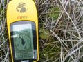
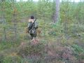
At the Hashpoint.
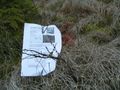
Hashpoint marked.
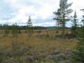
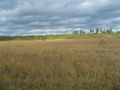
View to NW from the Hash.
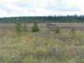
View to SW from the Hash.
Above the Hash.


Achievements
isopekka earned the Land geohash achievement
|
Other Geohashing Expeditions and Plans on This Day
Expeditions and Plans
| 2010-10-03 | ||
|---|---|---|
| Townsville, Australia | JimmyNZ, mattyk, jishy | Side of the road 75km out of Townsville. |
| Frankfurt am Main, Germany | Rincewind, Yakamoz | Near Michelshausen or Dagobertshausen, suburbs of Marburg, a dozen meters o... |
| Sheffield, United Kingdom | myka, possibly Fergus | In the West Wood, near Calverly |
| Malmö, Sweden | llavids | In the field outside Råby, Hörby, Skåne, Sweden. |
| Raahe, Finland | Ossisanni | Near forest road in Siikajoki municipality Merikylä village. |
| Kempele, Finland | Ossisanni | Back side of residential area in Tyrnävä town Murto village. |
| Rovaniemi, Finland | isopekka | About 40 km N from Rovaniemi, 10 km E from the village Patokoski, Finland. ... |