Difference between revisions of "2010-11-19 53 9"
imported>Pne (→Plans: Looking at the satellite picture, I'd probably also be on the better side of the road on the way back.) |
m |
||
| (10 intermediate revisions by 5 users not shown) | |||
| Line 1: | Line 1: | ||
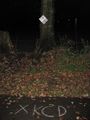
| − | + | [[Image:{{{image|2010-11-19 53 9--marker-street.jpg}}}|300px|thumb|left|Nothing says "adventure games" like chalk on pavement!]] | |
| − | |||
| − | [[Image:{{{image| | ||
| − | |||
| − | |||
| − | |||
| − | |||
| − | |||
| − | |||
{{meetup graticule | {{meetup graticule | ||
| lat=53 | | lat=53 | ||
| Line 13: | Line 5: | ||
| date=2010-11-19 | | date=2010-11-19 | ||
| graticule_name=Hamburg (West) | | graticule_name=Hamburg (West) | ||
| − | | graticule_link=Hamburg, Germany | + | | graticule_link=Hamburg (West), Germany |
}} | }} | ||
| Line 23: | Line 15: | ||
== Participants == | == Participants == | ||
*[[User:Pne|Pne]] | *[[User:Pne|Pne]] | ||
| + | *[[User:Mtu|mtu]] | ||
== Plans == | == Plans == | ||
| + | === Pne === | ||
I'll be driving to Borstel-Hohenraden this evening anyway to pick someone up, so I'll try to take a detour to drive through Ellerau. Since it's right next to the road (and it's expected to rain, and it'll be dark), I probably won't stop but will try for the [[speed racer achievement]], documenting my experience with a GPS tracklog. Since it's in the middle of a straight stretch of road, that shouldn't be too difficult. | I'll be driving to Borstel-Hohenraden this evening anyway to pick someone up, so I'll try to take a detour to drive through Ellerau. Since it's right next to the road (and it's expected to rain, and it'll be dark), I probably won't stop but will try for the [[speed racer achievement]], documenting my experience with a GPS tracklog. Since it's in the middle of a straight stretch of road, that shouldn't be too difficult. | ||
(Or perhaps I should go there on the way back, then it'd be a [[drag-along achievement]], too :D. Looking at the satellite picture, I'd probably also be on the better side of the road on the way back.) | (Or perhaps I should go there on the way back, then it'd be a [[drag-along achievement]], too :D. Looking at the satellite picture, I'd probably also be on the better side of the road on the way back.) | ||
| + | |||
| + | === mtu === | ||
| + | I'm probably going there some time during the afternoon, after university. I need some time for myself, so the ~30 min ride on the jolly old [http://commons.wikimedia.org/wiki/File:AKNTunnelbahnsteig.JPG AKN train] will be just perfect for me. | ||
| + | |||
| + | If Pne does stop the get out of his car at the hash after all, maybe he will find something I leave behind there :) | ||
== Expedition == | == Expedition == | ||
| − | + | === mtu=== | |
| + | From what I gather, I arrived at the hash almost exactly an hour before Pne drove by. The train ride was uneventful (except for how I was warily looked at by others on the train while checking my GPS, what with the fear or terrorists and all!). | ||
| + | |||
| + | [[File:2010-11-19 53 9--baumpflege.jpg|thumb|left|The first word on the sign is "tree care".]] While walking to the hash, I passed a large compound belonging to "Bollmann Tree Care". They had nice tree symbols all over their buildings, and even one that said '''"Save the Trees"''' in large letters. However, when I came around the corner and saw what exactly they were doing at that moment, I grew a little wary of them. See the photo: If this is their idea of ''tree care'', I don't ever want to be in one of their hospitals experiencing ''patient care''! | ||
| + | |||
| + | When I got to the hash, it was exactly on a fence next to the road, which seemed to be an electric fence: Strange rythmic noises came from some part of it, in any case. Luckily, I didn't need to cross it, but was comfortably within 1 meter of the hash standing next to the fence. I left chalk markings on the road and the footway next to it, and put up the poster on a tree. I waited a bit to maybe see Pne come by, but we missed each other by about half an hour, it seems. | ||
| + | |||
| + | On the way back, I freaked out some random guy by thinking he looked quite a bit like Pne did on his photos here in the wiki. The following dialog ensued: | ||
| + | |||
| + | '''mtu''' (''pointing at the man, in an inquiring tone''): Pne?<br> | ||
| + | '''Guy''': Excuse me?<br> | ||
| + | '''mtu''': You don't happen to be someone calling himself 'Pne'?<br> | ||
| + | '''Guy''' (''bewildered, shaking his head''): No!<br> | ||
| + | '''mtu''': All right then, sorry and thanks!<br> | ||
| + | '''Guy''': You're welcome... | ||
| + | |||
| + | I'd love to know what he thought about this exchange afterwards! Maybe I was trying to sell drugs? Setting up a terrorist plot? But why on earth in his little town? He may never know ;) | ||
| + | |||
| + | === Pne === | ||
| + | Funnily enough, when I told my satnav to calculate a route to from my home to my destination with the geohash as a via point, it took me down the road the "right" direction, though Google Maps' directions went the other way around... | ||
| + | |||
| + | At first, I thought the road would be 30 km/h, but that was only up to the last bend; the straight line was under the normal speed limit of 50 km/h for built-up areas. According to my satnav, I drove just slightly over it; oops. | ||
| + | |||
| + | The tracklog's resolution wasn't high enough to show that I was at the hashpoint, but the hashpoint was bracketed by the points (53.653458,9.948907) at 2010-11-19T16:47:15Z and (53.763619,9.952686) 15 seconds later at 2010-11-19T16:47:30Z. If you interpolate that 25.47% along a straight line, you'll find that I passed through (53.763499,9.9498695) at 2010-11-19T16:47:18.8Z, or about 0.006076° (8.5 m) north of the hashpoint: about as close as I could get while staying on the road. | ||
| + | |||
| + | My speed at the closest trackpoint to the geohash was 15.10 m/s (54.36 km/h). | ||
== Tracklog == | == Tracklog == | ||
| − | + | === Pne === | |
| + | * http://pne.mizinamo.org/geohashing/Tracklog_2010-11-19_53_9.gpx | ||
| − | == Photos == | + | == Photos == |
| − | < | + | === mtu === |
| − | Image:2010- | + | <gallery perrow="3"> |
| − | -- | + | Image:2010-11-19 53 9--tanneneck.jpg | Yes, Tanneneck is ''that'' kind of place... |
| − | + | Image:2010-11-19 53 9--stadtplan.jpg | A map of the town of Ellerau. | |
| + | Image:2010-11-19 53 9--sheep.jpg | Can you ''believe'' the way they're all ''looking'' at me? | ||
| + | Image:2010-11-19 53 9--proof.jpg | Check out the accuracy :) | ||
| + | Image:2010-11-19 53 9--grin.jpg | Looking closely, you can see that I am getting fat! | ||
| + | Image:2010-11-19 53 9--marker-tree.jpg | Leaving traces... | ||
</gallery> | </gallery> | ||
== Achievements == | == Achievements == | ||
{{#vardefine:ribbonwidth|800px}} | {{#vardefine:ribbonwidth|800px}} | ||
| − | + | {{Speed racer | |
| + | |||
| + | | latitude = 53 | ||
| + | | longitude = 9 | ||
| + | | date = 2010-11-19 | ||
| + | | name = [[User:Pne|Pne]] | ||
| + | | speed = (just over) 50 km/h | ||
| + | |||
| + | }} | ||
| + | {{Minesweeper geohash | ||
| + | |||
| + | | graticule = Hamburg (East), Germany | ||
| + | | ranknumber = 2 | ||
| + | | n = true | ||
| + | | w = true | ||
| + | | name = Pne | ||
| + | }} | ||
| − | + | {{land geohash | |
| − | + | | latitude = 53 | |
| − | [[ | + | | longitude = 9 |
| + | | date = 2010-11-19 | ||
| + | | name = [[User:Mtu|mtu]] | ||
| + | | image = 2010-11-19_53_9--marker-street.jpg}} | ||
| + | {{Public transport geohash | ||
| + | | latitude = 53 | ||
| + | | longitude = 9 | ||
| + | | date = 2010-11-19 | ||
| + | | busline = A1 | ||
| + | | name = [[User:Mtu|mtu]] | ||
| + | | image = 2010-11-19_53_9--tanneneck.jpg | ||
| + | }} | ||
| − | |||
| − | |||
| − | |||
[[Category:Expeditions]] | [[Category:Expeditions]] | ||
| − | |||
[[Category:Expeditions with photos]] | [[Category:Expeditions with photos]] | ||
| + | <!-- | ||
[[Category:Expeditions with videos]] | [[Category:Expeditions with videos]] | ||
| − | |||
--> | --> | ||
| − | |||
[[Category:Coordinates reached]] | [[Category:Coordinates reached]] | ||
| − | + | {{location|DE|SH|SE}} | |
| − | |||
| − | |||
| − | |||
| − | |||
| − | |||
| − | |||
| − | |||
| − | |||
| − | |||
Latest revision as of 21:17, 26 January 2021

| Fri 19 Nov 2010 in Hamburg (West): 53.7634227, 9.9498697 geohashing.info google osm bing/os kml crox |
Location
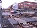
Right next to the road "Moortwiete" in Ellerau.
Participants
Plans
Pne
I'll be driving to Borstel-Hohenraden this evening anyway to pick someone up, so I'll try to take a detour to drive through Ellerau. Since it's right next to the road (and it's expected to rain, and it'll be dark), I probably won't stop but will try for the speed racer achievement, documenting my experience with a GPS tracklog. Since it's in the middle of a straight stretch of road, that shouldn't be too difficult.
(Or perhaps I should go there on the way back, then it'd be a drag-along achievement, too :D. Looking at the satellite picture, I'd probably also be on the better side of the road on the way back.)
mtu
I'm probably going there some time during the afternoon, after university. I need some time for myself, so the ~30 min ride on the jolly old AKN train will be just perfect for me.
If Pne does stop the get out of his car at the hash after all, maybe he will find something I leave behind there :)
Expedition
mtu
From what I gather, I arrived at the hash almost exactly an hour before Pne drove by. The train ride was uneventful (except for how I was warily looked at by others on the train while checking my GPS, what with the fear or terrorists and all!).

While walking to the hash, I passed a large compound belonging to "Bollmann Tree Care". They had nice tree symbols all over their buildings, and even one that said "Save the Trees" in large letters. However, when I came around the corner and saw what exactly they were doing at that moment, I grew a little wary of them. See the photo: If this is their idea of tree care, I don't ever want to be in one of their hospitals experiencing patient care!
When I got to the hash, it was exactly on a fence next to the road, which seemed to be an electric fence: Strange rythmic noises came from some part of it, in any case. Luckily, I didn't need to cross it, but was comfortably within 1 meter of the hash standing next to the fence. I left chalk markings on the road and the footway next to it, and put up the poster on a tree. I waited a bit to maybe see Pne come by, but we missed each other by about half an hour, it seems.
On the way back, I freaked out some random guy by thinking he looked quite a bit like Pne did on his photos here in the wiki. The following dialog ensued:
mtu (pointing at the man, in an inquiring tone): Pne?
Guy: Excuse me?
mtu: You don't happen to be someone calling himself 'Pne'?
Guy (bewildered, shaking his head): No!
mtu: All right then, sorry and thanks!
Guy: You're welcome...
I'd love to know what he thought about this exchange afterwards! Maybe I was trying to sell drugs? Setting up a terrorist plot? But why on earth in his little town? He may never know ;)
Pne
Funnily enough, when I told my satnav to calculate a route to from my home to my destination with the geohash as a via point, it took me down the road the "right" direction, though Google Maps' directions went the other way around...
At first, I thought the road would be 30 km/h, but that was only up to the last bend; the straight line was under the normal speed limit of 50 km/h for built-up areas. According to my satnav, I drove just slightly over it; oops.
The tracklog's resolution wasn't high enough to show that I was at the hashpoint, but the hashpoint was bracketed by the points (53.653458,9.948907) at 2010-11-19T16:47:15Z and (53.763619,9.952686) 15 seconds later at 2010-11-19T16:47:30Z. If you interpolate that 25.47% along a straight line, you'll find that I passed through (53.763499,9.9498695) at 2010-11-19T16:47:18.8Z, or about 0.006076° (8.5 m) north of the hashpoint: about as close as I could get while staying on the road.
My speed at the closest trackpoint to the geohash was 15.10 m/s (54.36 km/h).
Tracklog
Pne
Photos
mtu
Yes, Tanneneck is that kind of place...
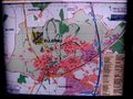
A map of the town of Ellerau.
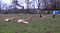
Can you believe the way they're all looking at me?
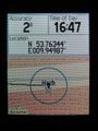
Check out the accuracy :)

Looking closely, you can see that I am getting fat!
Leaving traces...


Achievements

Pne achieved level 2 of the Minesweeper Geohash achievement
|
mtu earned the Land geohash achievement
|
mtu earned the Public transport geohash achievement
|