Difference between revisions of "2010-11-21 42 -78"
imported>MathMusic (→Ribbons) |
m (Replacing tracklog = File:Tracklog 2010-11-21 42 -78.png with tracklog = {{canonicalurl:File:Tracklog 2010-11-21 42 -78.png}}) |
||
| (14 intermediate revisions by 3 users not shown) | |||
| Line 17: | Line 17: | ||
<br><br> | <br><br> | ||
| + | Planned Route: <br> | ||
| + | [[File:Nov21_geohash_planned_route.png|200px]] | ||
| − | + | == Expedition == | |
| − | + | The trip went well, the drive-by had us within 24 feet (as close as I can see at 55 mph). I took the picture a fraction of a second later, so that's why it says 65 feet to the cache. I have the .gpx files ready, managed not to screw up the Tron route. A fun first Geohash close to home. | |
| − | + | <br><br> | |
| + | Deja Vu Route: | ||
| + | [[File:Deja_Vu_2010-11-21_42_-78.png|200px|Deja Vu Tracklog]] | ||
| + | Today's Route: | ||
| + | [[File:Tracklog_2010-11-21_42_-78.png|200px|Today's Tracklog]] | ||
| + | GPSr near Hash: | ||
| + | [[File:2010-11-21_42_-78_GPSr.jpg|200px|GPSr near the Geohash]] | ||
== Ribbons == | == Ribbons == | ||
| − | + | {{land geohash | |
| − | + | ||
| − | + | | latitude = 42 | |
| − | + | | longitude = -78 | |
| − | + | | date = 2010-11-21 | |
| + | | name = MathMusic | ||
| + | }} | ||
| + | <br> | ||
| + | {{Speed racer | ||
| + | |||
| + | | latitude = 42 | ||
| + | | longitude = -78 | ||
| + | | date = 2010-11-21 | ||
| + | | name = MathMusic | ||
| + | | speed = 55mph | ||
| + | }} | ||
| + | <br> | ||
| + | {{Déjà vu geohash | ||
| + | |||
| + | | latitude = 42 | ||
| + | | longitude = -78 | ||
| + | | date = 2010-11-21 | ||
| + | | name = MathMusic | ||
| + | | olddate = 2009-07-03 | ||
| + | }} | ||
| + | <br> | ||
| + | {{Tron | ||
| + | |||
| + | | latitude = 42 | ||
| + | | longitude = -78 | ||
| + | | date = 2010-11-21 | ||
| + | | name = MathMusic | ||
| + | | tracklog = {{canonicalurl:File:Tracklog 2010-11-21 42 -78.png}} | ||
| + | | possessive = his | ||
| + | }} | ||
| + | |||
| + | |||
===[[User:MathMusic|MathMusic]]=== | ===[[User:MathMusic|MathMusic]]=== | ||
| Line 36: | Line 76: | ||
[[Category:Expeditions with photos]] | [[Category:Expeditions with photos]] | ||
[[Category:Coordinates reached]] | [[Category:Coordinates reached]] | ||
| + | {{location|US|NY|GE}} | ||
Latest revision as of 12:49, 19 February 2020
| Sun 21 Nov 2010 in Buffalo: 42.9714152, -78.3468424 geohashing.info google osm bing/os kml crox |
Contents
About
Planning a Deja Vu, Speed Racer, Tron Hash for my first Geohash. Why not?
Definately do-able, and only about 3 miles from my house. Let's see how many ribbons we can get at once!
The Plan
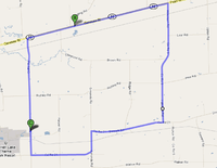
The plan: Taking a nice leisurely Sunday Drive past the Geohash (which is just two country blocks from my house). I have proof (via GPX log) that I was going down this road on July 3, 2009. Will try to take pics of GPSr as we fly by.
Expedition
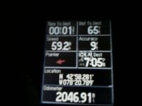
The trip went well, the drive-by had us within 24 feet (as close as I can see at 55 mph). I took the picture a fraction of a second later, so that's why it says 65 feet to the cache. I have the .gpx files ready, managed not to screw up the Tron route. A fun first Geohash close to home.
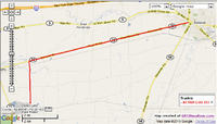
Deja Vu Route:
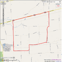
 Today's Route:
 GPSr near Hash:

Ribbons
MathMusic earned the Land geohash achievement
|
MathMusic earned the Déjà Vu Geohash Achievement
|
MathMusic earned the Tron achievement
|

