Difference between revisions of "2010-11-28 46 7"
imported>TheOneRing (Created page with '{{meetup graticule | lat=46 | lon=7 | date=2010-11-28 }} == The Place == The hashpoint is at a farm house near the village of Zimmerwald, which is itself 10 km South of Berne. …') |
imported>FippeBot m (Location) |
||
| (6 intermediate revisions by 2 users not shown) | |||
| Line 6: | Line 6: | ||
== The Place == | == The Place == | ||
| − | The | + | The geohash is at a farm house near the village of Zimmerwald, which is itself 10 km South of Berne. |
== Who Went == | == Who Went == | ||
| − | [[User:TheOneRing|TheOneRing]] - by | + | [[User:TheOneRing|TheOneRing]] - by public transport |
== The Expedition == | == The Expedition == | ||
| Line 21: | Line 21: | ||
<gallery perrow="6"> | <gallery perrow="6"> | ||
Image:20101128Bus.jpg|The bus I took to Zimmerwald | Image:20101128Bus.jpg|The bus I took to Zimmerwald | ||
| − | Image:20101128Farmhouse.jpg|The farm house at the | + | Image:20101128Farmhouse.jpg|The farm house at the geohash |
Image:20101128Me.jpg|Non-stupid grin | Image:20101128Me.jpg|Non-stupid grin | ||
Image:20101128Cows.jpg|Cows (probably deep frozen) | Image:20101128Cows.jpg|Cows (probably deep frozen) | ||
| Line 34: | Line 34: | ||
== Achievements == | == Achievements == | ||
| + | {{land geohash | latitude = 46 | longitude = 7 | date = 2010-11-28 | name = TheOneRing }} | ||
| + | {{Frozen Geohash | latitude = 46 | longitude = 7 | date = 2010-11-28 | temperature = -1°C | name = TheOneRing | }} | ||
| + | {{Public transport geohash | latitude = 46 | longitude = 7 | date = 2010-11-28 | name = TheOneRing}} | ||
| + | |||
| + | == Other Geohashing Plans and Expeditions on This Day == | ||
| + | |||
| + | {{expedition summaries|2010-11-28}} | ||
[[Category:Expeditions]] | [[Category:Expeditions]] | ||
[[Category:Expeditions with photos]] | [[Category:Expeditions with photos]] | ||
[[Category:Coordinates reached]] | [[Category:Coordinates reached]] | ||
| + | {{location|CH|BE}} | ||
Latest revision as of 04:46, 9 August 2019
| Sun 28 Nov 2010 in 46,7: 46.8809510, 7.4843471 geohashing.info google osm bing/os kml crox |
Contents
The Place
The geohash is at a farm house near the village of Zimmerwald, which is itself 10 km South of Berne.
Who Went
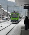
TheOneRing - by public transport
The Expedition
TheOneRing
At the village of Zimmerwald there is located the Zimmerwald observatory which is part of my work centre. So I know the area very well. I decided to go by bus to Zimmerwald and then walk the last 2 km to the hashpoint. The view was very nice, but the roads were quite slippery due to the snowfall in the last days.
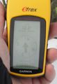
The hashpoint itself was located at a farm house and was easy to reach. The dog there was very alert what I was doing there. It did nothing but barking several times. I suspected that the temperature was low enough to get the Frozen Geohash achievement I brought a thermometer and I was right to do so.
After taking the other usual photographs I chose a different way back and walked to the village of Belp, which rewarded me with another wonderful view of the countryside and extended to the Alps (see below). Then I took the train back to Berne.
Photos
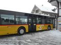
The bus I took to Zimmerwald
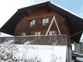
The farm house at the geohash

Non-stupid grin
Cows (probably deep frozen)
The proof that I reached the coordinates
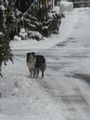
The dog of the farm house (was not happy about my presence)

The proof of the actual temperature
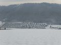
Wonderful view over the countryside
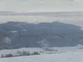
Same as before
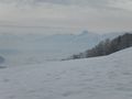
Again, but with the Alps in the background
The train back to Berne


Achievements
TheOneRing earned the Land geohash achievement
|

TheOneRing earned the Public transport geohash achievement
|
Other Geohashing Plans and Expeditions on This Day
Expeditions and Plans
| 2010-11-28 | ||
|---|---|---|
| Hamilton, New Zealand | Ellaruby, TunezNZ, Jonootto | Cambridge, Hamilton. In a park strip along side a housing area, Right on th... |
| Bern, Switzerland | TheOneRing, TheOneRing | | At the village of Zimmerwald there is located the Zimmerwald observatory wh... |
| Cambridge, United Kingdom | Sourcerer | A snowy wood of beech and oak, west of Snettisham, Norfolk, UK. |
| Oslo, Norway | Someone went | Nordengveien, Slependen, Oslo. In a bit of forest in a residential district... |
| Uppsala, Sweden | Someone went | About 8 km outside Uppsala, the closest by far for me since I started geoha... |