Difference between revisions of "2010-12-05 45 -122"
imported>Aperfectring ([live] Success! A nice lady let us into her back yard where we reached the point!) |
imported>FippeBot m (Location) |
||
| (4 intermediate revisions by 2 users not shown) | |||
| Line 16: | Line 16: | ||
__NOTOC__ | __NOTOC__ | ||
== Location == | == Location == | ||
| − | Tualatin Oregon, in | + | Tualatin, Oregon, on a trampoline in a back yard |
| + | |||
| + | {{PBGH_battleship | lat = 45 | lon = -122 | date = 2010-12-05}} | ||
== Participants == | == Participants == | ||
| − | * Jim | + | * [[User:Jiml|Jim]] |
| − | * APR | + | * [[User:Aperfectring|APR]] |
== Plans == | == Plans == | ||
| Line 27: | Line 29: | ||
== Expedition == | == Expedition == | ||
APR is coming by to pick up Jim. Jim's busy printing out Maps and such. | APR is coming by to pick up Jim. Jim's busy printing out Maps and such. | ||
| + | |||
| + | We set out on a very pretty afternoon south from Hillsboro to Tualatin. | ||
| + | |||
| + | We saw Mt. Hood on the way, which is unusual for this time of year. We dodged around a | ||
| + | injured car as we passed over Hwy 99W, and then continued south. APR's GPS sent us | ||
| + | in the right direction, and eventually we got to the correct address in a housing | ||
| + | development. | ||
| + | |||
| + | We walked up and rang the doorbell and attempted to explain why two random people wanted | ||
| + | to go into her backyard and take a picture. She gave us a strange look and said go ahead. | ||
| + | Once we had managed to get the gate to open for us, we walked in. We were at 16 feet when we | ||
| + | got to the edge of the trampoline. | ||
| + | |||
| + | Jim considered bouncing on the trampoline for an Air Geohash, but we decided that wouldn't | ||
| + | go over very well. We took a few pictures and headed for home, stopping to add a comment | ||
| + | to the Wiki before we left. | ||
*Success! A nice lady let us into her back yard where we reached the point! -- [[User:Aperfectring|aperfectring]] [http://www.openstreetmap.org/?lat=45.363222&lon=-122.827542&zoom=16&layers=B000FTF @45.3632,-122.8275] 22:06, 5 December 2010 (UTC) | *Success! A nice lady let us into her back yard where we reached the point! -- [[User:Aperfectring|aperfectring]] [http://www.openstreetmap.org/?lat=45.363222&lon=-122.827542&zoom=16&layers=B000FTF @45.3632,-122.8275] 22:06, 5 December 2010 (UTC) | ||
| − | |||
| − | |||
== Photos == | == Photos == | ||
| − | + | ||
| − | |||
| − | |||
<gallery perrow="5"> | <gallery perrow="5"> | ||
| + | File:2010-12-05_45_-122_apr01.jpg|APR's GPS proof | ||
| + | File:2010-12-05_45_-122_apr02.jpg|Jim at the hashpoint | ||
| + | File:2010-12-05_45_-122_apr03.jpg|The trampoline at the hashpoint. | ||
</gallery> | </gallery> | ||
== Achievements == | == Achievements == | ||
{{#vardefine:ribbonwidth|800px}} | {{#vardefine:ribbonwidth|800px}} | ||
| − | |||
| − | |||
| − | |||
| − | |||
| − | |||
| − | |||
| + | {{Land geohash | ||
| + | | latitude=45 | ||
| + | | longitude=-122 | ||
| + | | date=2010-12-05 | ||
| + | }} | ||
[[Category:Expeditions]] | [[Category:Expeditions]] | ||
| − | |||
| − | |||
| − | |||
| − | |||
[[Category:Expeditions with photos]] | [[Category:Expeditions with photos]] | ||
| − | |||
| − | |||
| − | |||
| − | |||
| − | |||
[[Category:Coordinates reached]] | [[Category:Coordinates reached]] | ||
| − | + | {{location|US|OR|WI}} | |
| − | |||
| − | |||
| − | |||
| − | |||
| − | |||
| − | |||
| − | |||
| − | |||
| − | |||
Latest revision as of 04:50, 9 August 2019
| Sun 5 Dec 2010 in 45,-122: 45.3561888, -122.7907086 geohashing.info google osm bing/os kml crox |
Location
Tualatin, Oregon, on a trampoline in a back yard
Today's battleship location is: C 4
Participants
Plans
We're both thinking about going. No timing yet.
Expedition
APR is coming by to pick up Jim. Jim's busy printing out Maps and such.
We set out on a very pretty afternoon south from Hillsboro to Tualatin.
We saw Mt. Hood on the way, which is unusual for this time of year. We dodged around a injured car as we passed over Hwy 99W, and then continued south. APR's GPS sent us in the right direction, and eventually we got to the correct address in a housing development.
We walked up and rang the doorbell and attempted to explain why two random people wanted to go into her backyard and take a picture. She gave us a strange look and said go ahead. Once we had managed to get the gate to open for us, we walked in. We were at 16 feet when we got to the edge of the trampoline.
Jim considered bouncing on the trampoline for an Air Geohash, but we decided that wouldn't go over very well. We took a few pictures and headed for home, stopping to add a comment to the Wiki before we left.
- Success! A nice lady let us into her back yard where we reached the point! -- aperfectring @45.3632,-122.8275 22:06, 5 December 2010 (UTC)
Photos
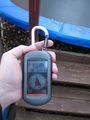
APR's GPS proof

Jim at the hashpoint
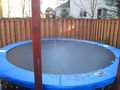
The trampoline at the hashpoint.


Achievements
This user earned the Land geohash achievement
|