Difference between revisions of "2011-01-09 45 -122"
imported>Jiml (Expand Template) |
imported>FippeBot m (Location) |
||
| (4 intermediate revisions by one other user not shown) | |||
| Line 1: | Line 1: | ||
| − | |||
<!-- If you did not specify these parameters in the template, please substitute appropriate values for IMAGE, LAT, LON, and DATE (YYYY-MM-DD format) | <!-- If you did not specify these parameters in the template, please substitute appropriate values for IMAGE, LAT, LON, and DATE (YYYY-MM-DD format) | ||
| Line 15: | Line 14: | ||
}} | }} | ||
| − | + | ||
__NOTOC__ | __NOTOC__ | ||
== Location == | == Location == | ||
| − | + | In the driveway of a farm near Hockinson, Washington | |
== Participants == | == Participants == | ||
| − | + | * [[User:Jiml|Jim]] | |
| + | |||
== Plans == | == Plans == | ||
| − | + | Jim's planning on heading up there, and maybe revisiting the [[2008-02-19 45 -122]] point. | |
== Expedition == | == Expedition == | ||
| − | |||
| − | == | + | === 2011 Hashpoint === |
| − | + | I printed out Google Maps and directions to both of the hashpoint, in hopes of getting some | |
| + | better pictures and information about the first Geohashing expedition. | ||
| + | |||
| + | I first went to today's hashpoint, which was fairly straightforward. As expected, it was | ||
| + | in the driveway of a home in a rural area. I felt strange about driving down the driveway, so | ||
| + | I managed to find a place to park alongside the road, and then walked back to the hashpoint. | ||
| + | |||
| + | I walked in, passing through the hashpoint, and then asked if I could take some pictures at | ||
| + | the home. They were amenable to the idea, so I walked back, and snapped a few pictures of | ||
| + | the GPS, hashpoint, and area. | ||
| + | |||
| + | === 2008 Hashpoint revisited === | ||
| + | I then headed north on the Hwy WA-503, which leads to Hwy WA-502, which takes me back | ||
| + | to Hwy I-5 (which heads North to Seattle.) A couple of exits north I hit La Center, which is | ||
| + | where the Feb 2008 hashpoint is. I found my way onto the correct side road, and eventually | ||
| + | got close to the hashpoint. | ||
| + | |||
| + | Then things started to go awry. | ||
| + | But the first apparent roadway in was labeled Private, so I figured I'd see if | ||
| + | there was another way in. I went down | ||
| + | the road in an attempt to go around, but that didn't help. I backtracked to the | ||
| + | obvious pathway in. It was confusing, since it seemed to be marked as a Public road as well | ||
| + | as a private road. I saw some folks go in, which made me suspect it was just a shared driveway, | ||
| + | so I went partway in to see what the setup was. There were a number of houses, so it | ||
| + | really was a shared roadway. | ||
| + | |||
| + | I finally noticed a "Dead End" sign, which made me think there wasn't another way in, at least | ||
| + | to the paved section the area. I'll dig for more info to see if I can figure out how the | ||
| + | original expedition managed to access the site. | ||
| + | |||
| + | |||
== Photos == | == Photos == | ||
| − | + | ||
| − | |||
| − | |||
<gallery perrow="5"> | <gallery perrow="5"> | ||
| + | Image:2011-01-09_45_-122-area1.jpg | The area around the hashpoint | ||
| + | Image:2011-01-09_45_-122-area2.jpg | The area around the hashpoint | ||
| + | Image:2011-01-09_45_-122-area4.jpg | The area around the hashpoint | ||
| + | Image:2011-01-09_45_-122-hashpoint.jpg | The actual hashpoint | ||
| + | Image:2011-01-09_45_-122-gps.jpg | the GPS at the hashpoint | ||
| + | Image:2011-01-09_45_-122-grin.jpg | A stupid, contorted grin | ||
| + | |||
| + | |||
</gallery> | </gallery> | ||
== Achievements == | == Achievements == | ||
{{#vardefine:ribbonwidth|800px}} | {{#vardefine:ribbonwidth|800px}} | ||
| − | |||
| + | * Land Geohash | ||
| + | * Ambassador | ||
| − | |||
| − | |||
| − | |||
| − | |||
| − | |||
| − | |||
| − | |||
| − | |||
[[Category:Expeditions]] | [[Category:Expeditions]] | ||
| − | + | ||
[[Category:Expeditions with photos]] | [[Category:Expeditions with photos]] | ||
| − | |||
| − | |||
| − | |||
| − | |||
| − | |||
[[Category:Coordinates reached]] | [[Category:Coordinates reached]] | ||
| − | + | {{location|US|WA|CR}} | |
| − | |||
| − | |||
| − | |||
| − | |||
| − | |||
| − | |||
| − | |||
| − | |||
| − | |||
Latest revision as of 05:10, 9 August 2019
| Sun 9 Jan 2011 in 45,-122: 45.7329038, -122.5043826 geohashing.info google osm bing/os kml crox |
Location
In the driveway of a farm near Hockinson, Washington
Participants
Plans
Jim's planning on heading up there, and maybe revisiting the 2008-02-19 45 -122 point.
Expedition
2011 Hashpoint
I printed out Google Maps and directions to both of the hashpoint, in hopes of getting some better pictures and information about the first Geohashing expedition.
I first went to today's hashpoint, which was fairly straightforward. As expected, it was in the driveway of a home in a rural area. I felt strange about driving down the driveway, so I managed to find a place to park alongside the road, and then walked back to the hashpoint.
I walked in, passing through the hashpoint, and then asked if I could take some pictures at the home. They were amenable to the idea, so I walked back, and snapped a few pictures of the GPS, hashpoint, and area.
2008 Hashpoint revisited
I then headed north on the Hwy WA-503, which leads to Hwy WA-502, which takes me back to Hwy I-5 (which heads North to Seattle.) A couple of exits north I hit La Center, which is where the Feb 2008 hashpoint is. I found my way onto the correct side road, and eventually got close to the hashpoint.
Then things started to go awry. But the first apparent roadway in was labeled Private, so I figured I'd see if there was another way in. I went down the road in an attempt to go around, but that didn't help. I backtracked to the obvious pathway in. It was confusing, since it seemed to be marked as a Public road as well as a private road. I saw some folks go in, which made me suspect it was just a shared driveway, so I went partway in to see what the setup was. There were a number of houses, so it really was a shared roadway.
I finally noticed a "Dead End" sign, which made me think there wasn't another way in, at least to the paved section the area. I'll dig for more info to see if I can figure out how the original expedition managed to access the site.
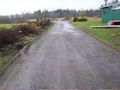
Photos
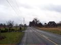
The area around the hashpoint
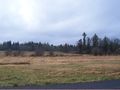
The area around the hashpoint
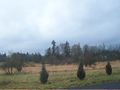
The area around the hashpoint
The actual hashpoint
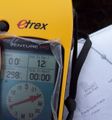
the GPS at the hashpoint

A stupid, contorted grin


Achievements
- Land Geohash
- Ambassador