Difference between revisions of "2011-02-04 45 -122"
imported>Jiml m (Get the location correct) |
imported>FippeBot m (Location) |
||
| (9 intermediate revisions by 2 users not shown) | |||
| Line 1: | Line 1: | ||
| − | + | [[Image:{{{image|2011-02-04_45_-122-area1.jpg}}}|thumb|left]] | |
| − | |||
| − | |||
| − | |||
| − | |||
| − | |||
| − | |||
| − | |||
{{meetup graticule | {{meetup graticule | ||
| lat=45 | | lat=45 | ||
| Line 22: | Line 15: | ||
* [[User:Jiml|Jim]] | * [[User:Jiml|Jim]] | ||
* [[User:Aperfectring|APR]] | * [[User:Aperfectring|APR]] | ||
| + | |||
| + | * [[User:Michael5000|Michael5000]] | ||
| + | * [[User:Mrs.5000|Mrs.5000]] | ||
== Plans == | == Plans == | ||
| − | It's in the middle of the road right | + | It's in the middle of the road right nearby. Of course we have |
to do it. It is near to work for both of us. | to do it. It is near to work for both of us. | ||
| Line 33: | Line 29: | ||
== Expedition == | == Expedition == | ||
| − | |||
| − | == | + | ===Westsiders=== |
| − | + | ||
| + | APR finished up work early, and headed home to obtain a camera and GPS which didn't go | ||
| + | to work with him. Jim finished up relatively early and APR came by and picked him | ||
| + | up. | ||
| + | |||
| + | They then debated which route to take to avoid traffic, and finally decided to take | ||
| + | some backroads, which proved to be a pretty good choice. They took a slightly early | ||
| + | side street, but soon found themselves a few hundred feet from the hashpoint. They | ||
| + | parked, avoiding a fire hydrant, and walked to the hashpoint. | ||
| + | |||
| + | The hashpoint proved to be, as expected, in the middle of a side street, which was | ||
| + | fairly busy. They got to 20 feet away, and started waiting to cross the street. | ||
| + | Traffic never abated enough to wander into the street and stand around to take | ||
| + | some photos, so they decided to declare it close enough and head back. | ||
| + | |||
| + | On the way out, we either drove through, or much closer to the hashpoint, but Jim | ||
| + | wasn't watching the GPS and APR was watching the road. | ||
| + | |||
| + | ===Eastsiders=== | ||
| + | |||
| + | Michael5000, having been earlier disappointed that a Friday hashpoint sat right on top of his Monday/Wednesday commute, returned home from work to find that Mrs.5000 had contrived a shoe-shopping expedition to the western suburbs. They headed out to Bronson Road and drove right over the top of that puppy. Then, after they bought shoes, they drove right back over the top of it again. | ||
| + | |||
| + | == Photos == | ||
| + | |||
| + | <gallery perrow="4"> | ||
| + | |||
| + | Image:2011-02-04_45_-122-APR.jpg |APR at the hashpoint | ||
| + | Image:2011-02-04_45_-122-area1.jpg | The area around the hashpoint | ||
| + | Image:2011-02-04_45_-122-corner.jpg |Nearby corner | ||
| + | Image:2011-02-04_45_-122-hashpoint.jpg |The hashpoint itself | ||
| − | + | File:2011-02-04 45 -122 At the Hashpoint.JPG|View from the hashpoint | |
| − | + | File:2011-02-04_45_-122_Shoes.JPG|New Shoes! | |
| − | |||
| − | |||
| − | |||
</gallery> | </gallery> | ||
== Achievements == | == Achievements == | ||
{{#vardefine:ribbonwidth|800px}} | {{#vardefine:ribbonwidth|800px}} | ||
| − | |||
| + | * Land geohash | ||
| − | |||
| − | |||
| − | |||
| − | [[Category: | + | [[Category:Expeditions]] |
| − | |||
| − | |||
| − | |||
| − | |||
[[Category:Expeditions with photos]] | [[Category:Expeditions with photos]] | ||
| − | |||
| − | |||
| − | |||
| − | |||
| − | |||
[[Category:Coordinates reached]] | [[Category:Coordinates reached]] | ||
| − | + | {{location|US|OR|WI}} | |
| − | |||
| − | |||
| − | |||
| − | |||
| − | |||
| − | |||
| − | |||
| − | |||
| − | |||
Latest revision as of 05:26, 9 August 2019

| Fri 4 Feb 2011 in 45,-122: 45.5400687, -122.8616239 geohashing.info google osm bing/os kml crox |
Location
Bronson Road, which is right next to Hwy 26, between 185th and Cornell exits
Participants
Plans
It's in the middle of the road right nearby. Of course we have to do it. It is near to work for both of us.
APR is going to head after work. Jim may do the same, or even wander by at Lunch time.
Shmulik says: Location: 17914 NW Bronson Rd, 97229 Rockcreek, Washington, Oregon, US - distance: 0km.
Expedition
Westsiders
APR finished up work early, and headed home to obtain a camera and GPS which didn't go to work with him. Jim finished up relatively early and APR came by and picked him up.
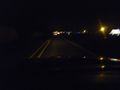
They then debated which route to take to avoid traffic, and finally decided to take some backroads, which proved to be a pretty good choice. They took a slightly early side street, but soon found themselves a few hundred feet from the hashpoint. They parked, avoiding a fire hydrant, and walked to the hashpoint.
The hashpoint proved to be, as expected, in the middle of a side street, which was fairly busy. They got to 20 feet away, and started waiting to cross the street. Traffic never abated enough to wander into the street and stand around to take some photos, so they decided to declare it close enough and head back.
On the way out, we either drove through, or much closer to the hashpoint, but Jim wasn't watching the GPS and APR was watching the road.
Eastsiders
Michael5000, having been earlier disappointed that a Friday hashpoint sat right on top of his Monday/Wednesday commute, returned home from work to find that Mrs.5000 had contrived a shoe-shopping expedition to the western suburbs. They headed out to Bronson Road and drove right over the top of that puppy. Then, after they bought shoes, they drove right back over the top of it again.
Photos
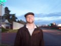
APR at the hashpoint
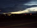
The area around the hashpoint
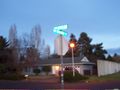
Nearby corner
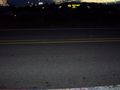
The hashpoint itself
View from the hashpoint
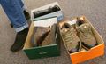
New Shoes!


Achievements
- Land geohash