Difference between revisions of "2011-02-06 48 11"
imported>The T-Man (→Expedition) |
imported>FippeBot m (Location) |
||
| (6 intermediate revisions by one other user not shown) | |||
| Line 1: | Line 1: | ||
| − | |||
<!-- If you did not specify these parameters in the template, please substitute appropriate values for IMAGE, LAT, LON, and DATE (YYYY-MM-DD format) | <!-- If you did not specify these parameters in the template, please substitute appropriate values for IMAGE, LAT, LON, and DATE (YYYY-MM-DD format) | ||
| Line 18: | Line 17: | ||
__NOTOC__ | __NOTOC__ | ||
== Location == | == Location == | ||
| − | + | At the edge of a forest in the very SW of München, close to the villages Gauting and Neuried. | |
== Participants == | == Participants == | ||
| − | + | *[[User:The_T-Man|The_T-Man]] | |
| + | *[[User:DerFlob|DerFlob]] | ||
| + | *Johanna | ||
== Plans == | == Plans == | ||
| Line 34: | Line 35: | ||
[[User:DerFlob|DerFlob]] joined them about 15 minutes later. He had taken a somewhat different route that led him almost exclusively through half-suburban, half-rural residential areas. The three geohashers spent some time near the point and then took a bit of a longer track back home. Throughout the expedition, weather was awesome - well, at least for that time of the year - (The_T-Man even wanted to buy some ice cream, however nobody wanted to sell any to him because it was still February) and the overall expedition was very pleasant, too. | [[User:DerFlob|DerFlob]] joined them about 15 minutes later. He had taken a somewhat different route that led him almost exclusively through half-suburban, half-rural residential areas. The three geohashers spent some time near the point and then took a bit of a longer track back home. Throughout the expedition, weather was awesome - well, at least for that time of the year - (The_T-Man even wanted to buy some ice cream, however nobody wanted to sell any to him because it was still February) and the overall expedition was very pleasant, too. | ||
| − | |||
| − | |||
| − | |||
== Photos == | == Photos == | ||
| − | |||
| − | |||
| − | |||
<gallery perrow="5"> | <gallery perrow="5"> | ||
| + | Image:2011-02-06_48_11_TMan01.jpg | The site of the crash. Luckily for those involved, there seemed to be no severe injuries and the fire department was based only about 800 m away. | ||
| + | Image:2011-02-06_48_11_TMan02.jpg | The forest with the hashpoint in it from outside. About 1 km to go. | ||
| + | Image:2011-02-06_48_11_TMan03.jpg | Johanna heading towards the hashpoint. | ||
| + | Image:2011-02-06_48_11_TMan06.jpg | The hashpoint | ||
| + | Image:2011-02-06_48_11_TMan07.jpg | GPS says we're there. | ||
| + | Image:2011-02-06_48_11_TMan09.jpg | Coordinates seem to fit. | ||
| + | Image:2011-02-06_48_11_TMan10.jpg | Sort of stupid grin. | ||
</gallery> | </gallery> | ||
== Achievements == | == Achievements == | ||
| − | {{ | + | {{Earliest geohasher | latitude = 48 | longitude = 11 | date = 2011-02-06 | name = [[User:The_T-Man|The_T-Man]] | image = 2011-02-06_48_11_TMan10.jpg}} |
| − | |||
| − | |||
| − | |||
| − | |||
| − | |||
| − | |||
| − | |||
| − | |||
| − | |||
| − | |||
| − | |||
| − | |||
[[Category:Expeditions]] | [[Category:Expeditions]] | ||
| − | |||
[[Category:Expeditions with photos]] | [[Category:Expeditions with photos]] | ||
| − | |||
| − | |||
| − | |||
| − | |||
| − | |||
[[Category:Coordinates reached]] | [[Category:Coordinates reached]] | ||
| − | + | {{location|DE|BY|M}} | |
| − | |||
| − | |||
| − | |||
| − | |||
| − | |||
| − | |||
| − | |||
| − | |||
| − | |||
Latest revision as of 05:28, 9 August 2019
| Sun 6 Feb 2011 in 48,11: 48.0878971, 11.4495572 geohashing.info google osm bing/os kml crox |
Location
At the edge of a forest in the very SW of München, close to the villages Gauting and Neuried.
Participants
Plans
- I really like the coordinates for 2011-02-06. Maybe anyone else would like to go there, too, Johanna and me would probably be there around 3 or 4 p.m., most likely by underground (U3). --The T-Man 15:34, 4 February 2011 (EST)
- Yes, both the coords and the time sound good. And supposedly, it'll even be warm and sunny. And I should ride my bike during daylight hours again, considering I have only biked to the train station in the dark recently. It's just that (a) my plans for the weekend probably won't include much sleep on Saturday night (yay!), and (b) I have some broken electronic machinery here that's not mine and needs fixing in an urgent fashion (cause of failure is tracked down, but still some hours of work to go). So I can't really promise I'll make it. --Zb 16:29, 4 February 2011 (EST)
- Since, it been too long, that i've been at a geohash and I sunday happens to be my day off, i'll probably be there, too, by underground. --DerFlob 19:27, 4 February 2011 (EST)
- We're now aiming to visit the point at around 3 p.m., further details to follow. Hope that works for everybody. --The T-Man 04:42, 6 February 2011 (EST)
- Since we probably won't have lunch before 2pm, I guess I can't make it before 3:30pm. Taking the underground, that arrives at 3pm at Fürstenried West plus the walk, of i guess about half an hour. --DerFlob 06:20, 6 February 2011 (EST)
- We're now aiming to visit the point at around 3 p.m., further details to follow. Hope that works for everybody. --The T-Man 04:42, 6 February 2011 (EST)
- Since, it been too long, that i've been at a geohash and I sunday happens to be my day off, i'll probably be there, too, by underground. --DerFlob 19:27, 4 February 2011 (EST)
Expedition
The_T-Man and Johanna took an underground train (U3) to Fürstenried West which is in the very SW of München. They walked about 3km past what had apparently been a rather serious traffic accident (fortunately all those involved seemed to have sustained no major injuries), through a residential area and then through a small commercial district until they arrived at the forest they were looking for. The hashpoint was located some 300-400 m in the forest, very close to the path.
DerFlob joined them about 15 minutes later. He had taken a somewhat different route that led him almost exclusively through half-suburban, half-rural residential areas. The three geohashers spent some time near the point and then took a bit of a longer track back home. Throughout the expedition, weather was awesome - well, at least for that time of the year - (The_T-Man even wanted to buy some ice cream, however nobody wanted to sell any to him because it was still February) and the overall expedition was very pleasant, too.
Photos
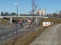
The site of the crash. Luckily for those involved, there seemed to be no severe injuries and the fire department was based only about 800 m away.
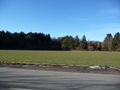
The forest with the hashpoint in it from outside. About 1 km to go.
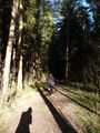
Johanna heading towards the hashpoint.
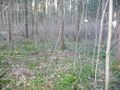
The hashpoint
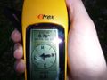
GPS says we're there.
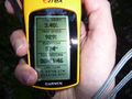
Coordinates seem to fit.
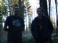
Sort of stupid grin.


Achievements
The_T-Man earned the Earliest geohasher achievement
|