Difference between revisions of "2011-02-26 45 -122"
imported>Jiml (A few details to start with) |
Michael5000 (talk | contribs) (→Tracklog) |
||
| (17 intermediate revisions by 5 users not shown) | |||
| Line 11: | Line 11: | ||
| lat=45 | | lat=45 | ||
| lon=-122 | | lon=-122 | ||
| − | | date= | + | | date=2011-02-26 |
}} | }} | ||
| Line 17: | Line 17: | ||
__NOTOC__ | __NOTOC__ | ||
== Location == | == Location == | ||
| − | + | On the Columbia River Bike Path between Marine Drive and the Columbia. | |
== Participants == | == Participants == | ||
* [[User:Jiml|Jim]] | * [[User:Jiml|Jim]] | ||
| + | * [[User:Michael5000|Michael5000]] | ||
| + | * [[User:Kydlt|Kydlt]] | ||
| + | |||
== Plans == | == Plans == | ||
| − | Jim has a get-together in Salem, so was going to leave shortly to try to go to the | + | '''Jim''' has a get-together in Salem, so was going to leave shortly to try to go to the |
hashpoint before heading South. | hashpoint before heading South. | ||
| + | |||
| + | '''Michael5000''' planned, as a new year's resolution with [[User:UnwiseOwl|UnwiseOwl]], to go geohashing on Feb. 26 '''no matter what'''. It's just good luck that today's hashpoint turned out to be something of a creampuff. | ||
| + | |||
| + | '''Kydlt''' went today too. | ||
== Expedition == | == Expedition == | ||
| − | |||
| − | == | + | === Expedition One=== |
| − | + | '''Michael5000''' dressed pretty warmly for a sub-freezing bicycle ride, but still lost track of his toes four miles into the nineteen-mile jaunt. Google Maps clearly shows the hashpoint on the trail; by my GPS the point was about a foot and a half north of the trail. I left a message for passers-by, and no doubt somebody at the other end of a CCT camera noticed the dude with a black balaclava making chalk marks and photographing airport operations. Then I rode home. | |
| + | |||
| + | === Expedition Two === | ||
| + | '''Kydlt''' ' made it @ about 15:30. Photos soon, after dinner. But I am still working on my upload skills. Hell, I got my name wrong the 1st time' | ||
| + | |||
| + | === Expedition Three === | ||
| + | Jim should have been at the hashpoint around 4PM, but got stuck on side streets that didn't connect, and finally actually | ||
| + | got out there at about 5PM. He passed by it about 3 times trying to figure out where to leave the car where | ||
| + | it would be safe, and finally setted on the original place he had thought of. | ||
| + | |||
| + | He photographed the area, and Michael5000's chalk markings and went on to run errands. | ||
== Photos == | == Photos == | ||
| − | + | ||
| − | |||
| − | |||
<gallery perrow="5"> | <gallery perrow="5"> | ||
| + | File:2010-02-26_45_-122_Me.JPG|I don't mind telling you it was a cold day for a bike ride. | ||
| + | File:2010-02-26_45_-122_Trail_Bear.JPG|The Columbia River Bike Trail is quite awesome. | ||
| + | File:2010-02-26_45_-122_Plane.JPG|The hashpoint is right off the end of the north runway at PDX. I was grazed by Horizon's plane with the livery of my ''alma mater''! | ||
| + | File:2010-02-26 45 -122 Bear Scrawl.JPG|We left a message for other cold-weather adventurers. | ||
| + | |||
| + | Image:chalk msg.JPG|My PN-20 waiting to get ran over. | ||
| + | Image:down by the riverside.JPG|Down by the riverside. | ||
</gallery> | </gallery> | ||
== Achievements == | == Achievements == | ||
{{#vardefine:ribbonwidth|800px}} | {{#vardefine:ribbonwidth|800px}} | ||
| − | |||
| + | * Land Geohash for all | ||
| − | + | {{Frozen Geohash | |
| − | + | | latitude = 45 | |
| − | + | | longitude = -122 | |
| + | | date = 2011-02-26 | ||
| + | | temperature = 28°F | ||
| + | | name = michael5000 | ||
| + | }} | ||
| − | |||
| − | |||
[[Category:Expeditions]] | [[Category:Expeditions]] | ||
| − | |||
[[Category:Expeditions with photos]] | [[Category:Expeditions with photos]] | ||
| − | |||
| − | |||
| − | |||
| − | |||
[[Category:Coordinates reached]] | [[Category:Coordinates reached]] | ||
| − | + | {{location|US|OR|MU}} | |
| − | |||
| − | |||
| − | |||
| − | |||
| − | |||
| − | |||
| − | |||
| − | |||
| − | |||
Latest revision as of 05:24, 13 February 2022
| Sat 26 Feb 2011 in 45,-122: 45.5847362, -122.5654490 geohashing.info google osm bing/os kml crox |
Location
On the Columbia River Bike Path between Marine Drive and the Columbia.
Participants
Plans
Jim has a get-together in Salem, so was going to leave shortly to try to go to the hashpoint before heading South.
Michael5000 planned, as a new year's resolution with UnwiseOwl, to go geohashing on Feb. 26 no matter what. It's just good luck that today's hashpoint turned out to be something of a creampuff.
Kydlt went today too.
Expedition
Expedition One
Michael5000 dressed pretty warmly for a sub-freezing bicycle ride, but still lost track of his toes four miles into the nineteen-mile jaunt. Google Maps clearly shows the hashpoint on the trail; by my GPS the point was about a foot and a half north of the trail. I left a message for passers-by, and no doubt somebody at the other end of a CCT camera noticed the dude with a black balaclava making chalk marks and photographing airport operations. Then I rode home.
Expedition Two
Kydlt ' made it @ about 15:30. Photos soon, after dinner. But I am still working on my upload skills. Hell, I got my name wrong the 1st time'
Expedition Three
Jim should have been at the hashpoint around 4PM, but got stuck on side streets that didn't connect, and finally actually got out there at about 5PM. He passed by it about 3 times trying to figure out where to leave the car where it would be safe, and finally setted on the original place he had thought of.
He photographed the area, and Michael5000's chalk markings and went on to run errands.
Photos

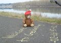
I don't mind telling you it was a cold day for a bike ride.
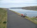
The Columbia River Bike Trail is quite awesome.
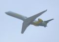
The hashpoint is right off the end of the north runway at PDX. I was grazed by Horizon's plane with the livery of my alma mater!
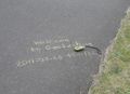
We left a message for other cold-weather adventurers.
My PN-20 waiting to get ran over.

Down by the riverside.


Achievements
- Land Geohash for all
