Difference between revisions of "2011-03-20 52 -0"
imported>Jiml m (Fix typos) |
m (Location correction) |
||
| (7 intermediate revisions by 2 users not shown) | |||
| Line 1: | Line 1: | ||
| − | |||
| − | |||
| − | |||
| − | |||
{{meetup graticule | {{meetup graticule | ||
| lat=52 | | lat=52 | ||
| Line 8: | Line 4: | ||
| date=2011-03-20 | | date=2011-03-20 | ||
| graticule_name=Northampton | | graticule_name=Northampton | ||
| − | | graticule_link=Northampton, United Kingdom}} | + | | graticule_link=Northampton, United Kingdom |
| + | }} | ||
| + | |||
| + | == Location == | ||
| + | |||
| + | Multihash 3 of 5. In a field at Twywell Hills and Dales, about 4.5 miles east of Kettering, UK. | ||
| + | |||
| + | [[2011-03-20 53 -1]] ::[[2011-03-20 52 -1]] ::[[2011-03-20 52 -0]] ::[[2011-03-20 52 0]] ::[[2011-03-20 52 1]] | ||
== Participants == | == Participants == | ||
| Line 19: | Line 22: | ||
The hash was just off the A14 in a popular picnic and walking location with free parking. There were several public footpaths and one led straight to the hashpoint. There were views of wind turbines on nearby high ground. It was a warm breezy spring evening and the walk was 1.1 km from the car park. Very pleasant. | The hash was just off the A14 in a popular picnic and walking location with free parking. There were several public footpaths and one led straight to the hashpoint. There were views of wind turbines on nearby high ground. It was a warm breezy spring evening and the walk was 1.1 km from the car park. Very pleasant. | ||
| + | |||
| + | This is now my favourite stopping place on the journey from my home to my friends in Staffordshire. Geohashing can be useful. | ||
== Photo Gallery == | == Photo Gallery == | ||
| − | <gallery | + | <gallery> |
Image:2011-03-20_Sourcerer.jpg|Google Earth View of the 599 km Journey. | Image:2011-03-20_Sourcerer.jpg|Google Earth View of the 599 km Journey. | ||
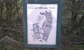
Image:2011-03-20 52 -0 Sourcerer 1.jpg|Sign near the hashpoint. | Image:2011-03-20 52 -0 Sourcerer 1.jpg|Sign near the hashpoint. | ||
| Line 31: | Line 36: | ||
</gallery> | </gallery> | ||
| − | == | + | {{Sourcerer_links |
| − | + | | prev = 2011-03-20 52 -1 | |
| − | + | | curr = 2011-03-20 52 -0 | |
| + | | next = 2011-03-20 52 0 | ||
| + | | date = 2011-03-20 | ||
| + | }} | ||
| + | [[Category:Expeditions]] | ||
[[Category:Expeditions with photos]] | [[Category:Expeditions with photos]] | ||
[[Category:Coordinates reached]] | [[Category:Coordinates reached]] | ||
| + | {{location|GB|ENG|NNH}} | ||
Latest revision as of 14:11, 4 December 2022
| Sun 20 Mar 2011 in Northampton: 52.3877725, -0.6268758 geohashing.info google osm bing/os kml crox |
Contents
Location
Multihash 3 of 5. In a field at Twywell Hills and Dales, about 4.5 miles east of Kettering, UK.
2011-03-20 53 -1 ::2011-03-20 52 -1 ::2011-03-20 52 -0 ::2011-03-20 52 0 ::2011-03-20 52 1
Participants
Expedition
This was multihash three of five on a 599 km journey.
The hash was just off the A14 in a popular picnic and walking location with free parking. There were several public footpaths and one led straight to the hashpoint. There were views of wind turbines on nearby high ground. It was a warm breezy spring evening and the walk was 1.1 km from the car park. Very pleasant.
This is now my favourite stopping place on the journey from my home to my friends in Staffordshire. Geohashing can be useful.
Photo Gallery
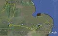
Google Earth View of the 599 km Journey.
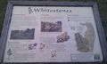
Sign near the hashpoint.
Sign near the hashpoint.
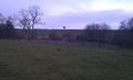
The Hashpoint.
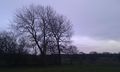
The Hashpoint.
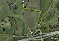
Google Earth View of the Walk.


Expeditions and Plans
| 2011-03-20 | ||
|---|---|---|
| Varna, Bulgaria | Kisolre | In a ex corn field near Voivodino village. |
| Mannheim, Germany | ilpadre, fivetonsofflax, Euterkuh, Mampfred, LadyBB | In a field south of Eppelheim. |
| Schweinfurt, Germany | Reinhard | On a field at the foot of the "Großen Gleichberg" (big equal mountain). |
| Halle (Saale), Germany | Rincewind, Yakamoz | For a change, the hashpoint was on a field near Querfurt. |
| Northampton, United Kingdom | Sourcerer | Multihash 3 of 5. In a field at Twywell Hills and Dales, about 4.5 miles ea... |
| Birmingham, United Kingdom | Sourcerer | Multihash 2 of 5. In a field about five miles west of Coventry, UK. 2011-03-20 53 -1 ::2011-03-20 52 -1 ::... |
| Cambridge, United Kingdom | Sourcerer | Multihash 4 of 5. In a field about a mile west of the Elveden Center Parcs ... |
| Norwich, United Kingdom | Sourcerer | Multihash 5 of 5. In a field north west of Frostenden, two miles west of Wr... |
| Sheffield, United Kingdom | Sourcerer | Multihash 1 of 5. In a field north of the A57 at Hollow Meadows about seven... |
| Vantaa, Finland | small oaks | The coordinates were in a private yard roughly 50 m off the spot I managed ... |
Sourcerer's Expedition Links
2011-03-20 52 -1 - 2011-03-20 52 -0 - 2011-03-20 52 0 - KML file download of Sourcerer's expeditions for use with Google Earth.